Time-series measurements of oceanographic and water quality data collected in the Herring River, Wellfleet, Massachusetts, USA, November 2018 to November 2019
By Steven E. Suttles, Olivia A. De Meo, Neil K. Ganju, Robert D. Bales, and Eric D. Marsjanik
https://doi.org/10.5066/P95AE74D
Dates
Published: April 21, 2023
Summary
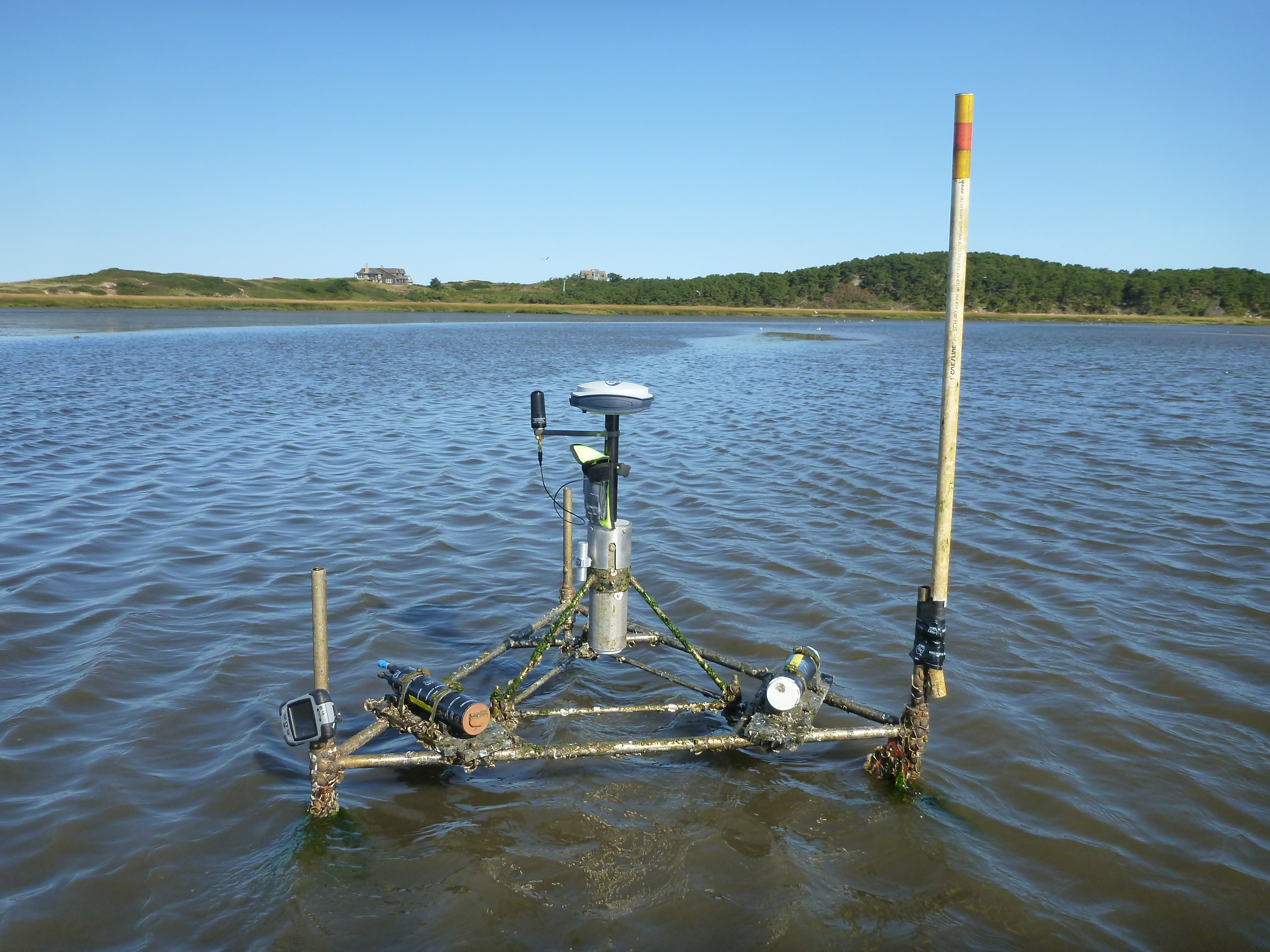
Restoration in the tidally restricted Herring River Estuary in Wellfleet, MA benefits from understanding pre-restoration sediment transport conditions. Submerged sensors were deployed at four sites landward and seaward of the Herring River restriction to measure water velocity, water quality, water level, waves, and seabed elevation. These data will be used to evaluate sediment dynamics and geomorphic change and inform marsh modeling efforts over tidal and seasonal timescales. Submerged sensors were deployed to collect a time series of water level, velocity, pressure, waves, seabed elevation, turbidity, pH, fluorescent dissolved organic matter (fDOM), chlorophyll, dissolved oxygen, blue-green algae, conductivity, and temperature data. These data were collected as part of a larger study, funded by the USGS-NPS Natural Resource Preservation Program (NRPP), of four sites within the Northeast Coastal and Barrier Network: Cape Cod National Seashore, Fire Island National Seashore, Gateway National Recreation Area, and Assateague Island National Seashore. The overarching goals of this study are to identify the dominant sources of sediment, determine how sediment transport varies over time, and analyze sediment availability to the marshes in order to inform management efforts
Time Series Data
-
Time-series measurements of oceanographic and water quality data collected in the Herring River, Wellfleet, Massachusetts, USA, November 2018 to November 2019
Submerged sensors were deployed to collect a time series of water level, velocity, pressure, waves, seabed elevation, turbidity, pH, fluorescent dissolved organic matter (fDOM), chlorophyll, dissolved oxygen, blue-green algae, conductivity,5 and temperature data.
Data Files
11201Aexo-a.nc - 1.3 MB - MD5:16fc54c1730491d0e0e06d84c417a8d7
11201Bexo-a.nc - 1000.4 KB - MD5:fc0fd9c1efca40c6fa828ea9001b449f
11201Cexo-a.nc - 1.0 MB - MD5:169f9c081d37c2be573cfe0da4213365
11201Dexo-a.nc - 1.1 MB - MD5:e0b3a42e7c3fbde8a54ccc7402fc8fe7
11211Aaqd-a.nc - 34.2 MB - MD5:5da88f4250fbd6a143d1b91ca5534d35
11211Baqd-a.nc - 32.4 MB - MD5:21768ee08674c47626891a47a2d23719
11211Caqd-a.nc - 28.6 MB - MD5:8ae0c921d129e7eeeff94d4caf9ea7e1
11211Daqd-a.nc - 25.9 MB - MD5:e8179a4f96e3462b097aa7a37eccfd36
11212Aexo-a.nc - 1.3 MB - MD5:24dc7afd016e6cf3462fd6ec607fa5bd
11212Bexo-a.nc - 1.3 MB - MD5:5122c99ce6839cff9012adf7fde1aa4e
11212Cexo-a.nc - 1.2 MB - MD5:f0bcda170a445c133abcc446eefb74bf
11212Dexo-a.nc - 1.1 MB - MD5:32721c4915345f4598a9c9889555fa00
11213Adwb-cal.nc - 356.7 MB - MD5:44341a7279f465d8cf5ebbff4032128b
11213Adws-a.nc - 76.3 MB - MD5:4d59029f165e477f53415232a35f80b7
11213Bdwb-cal.nc - 338.2 MB - MD5:ccf96109f20e73cb8c48546ff38ef34d
11213Bdws-a.nc - 72.4 MB - MD5:c191b4ff1a1431ba442c32e6bba3fea3
11213Ddwb-cal.nc - 116.2 MB - MD5:aec9335a96bd1851ced2c6da8cce5669
11213Ddws-a.nc - 24.9 MB - MD5:8249222f0b89f4fbbd89abdb2d398e55
11221Aea-a.nc - 7.4 MB - MD5:99b308fc82c2cff6866bffcfdecf6ec2
11221Aeab-cal.nc - 69.1 MB - MD5:8da70eca165c9376a55dafa37186eadb
11221Bea-a.nc - 9.8 MB - MD5:9274577169bab94addf1319b41499f19
11221Beab-cal.nc - 91.8 MB - MD5:9c7938bc735c60c23e0b99ade813ec4b
11221Cea-a.nc - 10.2 MB - MD5:2323d5428b599113b9b3d6fc71d8efe4
11221Ceab-cal.nc - 96.3 MB - MD5:2a1513cb3a927f74a4b3160f83310e3d
11221Dea-a.nc - 7.1 MB - MD5:f0f0f393b2b6762fce61047d79f73b46
11221Deab-cal.nc - 131.9 MB - MD5:2783bb215bdaf495bcbc86a5025fcbf1
11222Adwb-cal.nc - 236.6 MB - MD5:857539fa6680b2e79d4c7f92c04e2e17
11222Adws-a.nc - 50.6 MB - MD5:53a486d5a55320293e4444a0e1b86a22
11222Bdwb-cal.nc - 315.0 MB - MD5:71630631d991e727b1906e353d420592
11222Bdws-a.nc - 67.4 MB - MD5:4002e1f8c7a84dd6707d46266e8e4598
11222Cdwb-cal.nc - 330.5 MB - MD5:c1dfd6fc536416947af89fff41cc0968
11222Cdws-a.nc - 70.7 MB - MD5:4dd9b321b173f7576801fe85524f79d7
11222Ddwb-cal.nc - 229.7 MB - MD5:fb5f5e11c4e5738e3b57ac82a2d2850b
11222Ddws-a.nc - 49.2 MB - MD5:e071062069ce90df1734924f14639e6d
11223Aecn-a_mask.nc - 161.3 KB - MD5:b6371ec712ea8b5c390ba6d4246bce3d
11223Becn-a_mask.nc - 200.4 KB - MD5:bf7f1439764014b8cbbb0dfbdf9deb6a
11223Cecn-a_mask.nc - 210.7 KB - MD5:4c14bbe47666aa2821a18ac007ee6aa0
11223Decn-a_mask.nc - 158.3 KB - MD5:fb93446824d6dec41dc0e42c73e957d8
11231Aea-a.nc - 7.4 MB - MD5:0c4b1babad6a94ccb052733945c3f4d5
11231Aeab-cal.nc - 69.1 MB - MD5:fbab2455101a4036a79f1ce45a93e22b
11231Bea-a.nc - 9.8 MB - MD5:0fad25538b4772b5cac9d40858199af9
11231Beab-cal.nc - 91.8 MB - MD5:480a135effcb2fa54c90b394780b97ca
11231Cea-a.nc - 10.2 MB - MD5:de6e7f276d4d2f1f62f2b5c94a7fd27c
11231Ceab-cal.nc - 96.3 MB - MD5:44c1ed4037d348c31107b34439c82740
11231Dea-a.nc - 7.1 MB - MD5:44782736a347d201aec7e2587463e8c7
11231Deab-cal.nc - 131.8 MB - MD5:6e3f1c9fcffae091979bab58cf4c4ca6
11232Bdwb-cal.nc - 314.9 MB - MD5:0c94f02538721142e49a293eff728eae
11232Bdws-a.nc - 67.4 MB - MD5:b9102ecfb4f3cc7235dfd24bce09fea2
11232Cdwb-cal.nc - 330.4 MB - MD5:2bdbef406ec6290424df7c3d5e5c005b
11232Cdws-a.nc - 70.7 MB - MD5:8a444a084a70f4ae03d9552223f3e8a1
11232Ddwb-cal.nc - 229.4 MB - MD5:f64a05ce4811e8f17c84afbeb16c1050
11232Ddws-a.nc - 49.1 MB - MD5:e86d8cc9ac244aea94aca8d2d4843642
11233Aecn-a_mask.nc - 161.2 KB - MD5:c7cc743723db4e28a87ac34e59b935b1
11233Becn-a_mask.nc - 202.0 KB - MD5:0764d278d11625606a6e20db2307ec21
11233Cecn-a_mask.nc - 210.6 KB - MD5:599e54af94eb234884bb925b2c3ecee8
11233Decn-a_mask.nc - 158.3 KB - MD5:5cba3ee67b74317056a8fe71f6031eb4
wellfleet_timeseries_ncfiles.zip - 1.6 GB - MD5:16cfcf29f877426134f324aa20cf8c60
Other Data Access
Metadata Files
Wellfleet_TimeSeries_Metadata.xml - 33.3 KB
Wellfleet_TimeSeries_Metadata.txt - 32.3 KB


Related Field Activities
- 2018-057-FA - View Details
- 2018-058-FA - View Details
- 2019-005-FA - View Details
- 2019-013-FA - View Details
- 2019-015-FA - View Details
- 2019-020-FA - View Details
- 2019-026-FA - View Details
- 2019-029-FA - View Details
- 2019-030-FA - View Details
- 2019-035-FA - View Details
- 2019-039-FA - View Details
- 2019-040-FA - View Details
Suggested Citation
Suttles, S.E., De Meo, O.A., Ganju, N.K., Bales, R.D., and Marsjanik, E.D., 2023, Time-series measurements of oceanographic and water quality data collected in the Herring River, Wellfleet, Massachusetts, USA, November 2018 to November 2019: U.S. Geological Survey data release, https://doi.org/10.5066/P95AE74D..
Overview Image