Hydrodynamic and sediment transport data from Whale's Tail marsh and adjacent waters in South San Francisco Bay, California 2021-2022
By Joanne C. T. Ferreira, Jessica R. Lacy, Samantha C. McGill, Lukas T. WinklerPrins, Daniel J. Nowacki, Andrew W. Stevens, and Angela C. Tan
https://doi.org/10.5066/P972R6AW
Dates
Published: April 12, 2023
Summary
The U.S. Geological Survey Pacific Coastal and Marine Science Center collected hydrodynamic and sediment-transport data at shallow water sites in South San Francisco Bay and in the Whale's Tail South marsh in Eden Landing Ecological Reserve in Alameda County, CA in 2021 and 2022. This data release includes hydrodynamic and sediment transport time-series data spanning from June 2021 to January 2022, as well as sediment bed properties and water column suspended-sediment concentrations Details on station location, instrumentation, and measured variables are included in sections for each data type. The data were collected to determine sediment supply and sediment delivery to marshes, both in the bay and in tidal creeks as well as across the bay-marsh interface during varying tidal and wave conditions. The goal of the project was to more accurately predict the fate of marshes and to optimize management actions. They were collected as part of a collaborative study with the USGS Western Ecological Research Center. These data are intended for science researchers, students, policy makers, and the general public.
Time Series Data
-
Hydrodynamic time-series data from Whale's Tail South marsh in Eden Landing Ecological Reserve in Alameda County, CA in 2021 and 2022
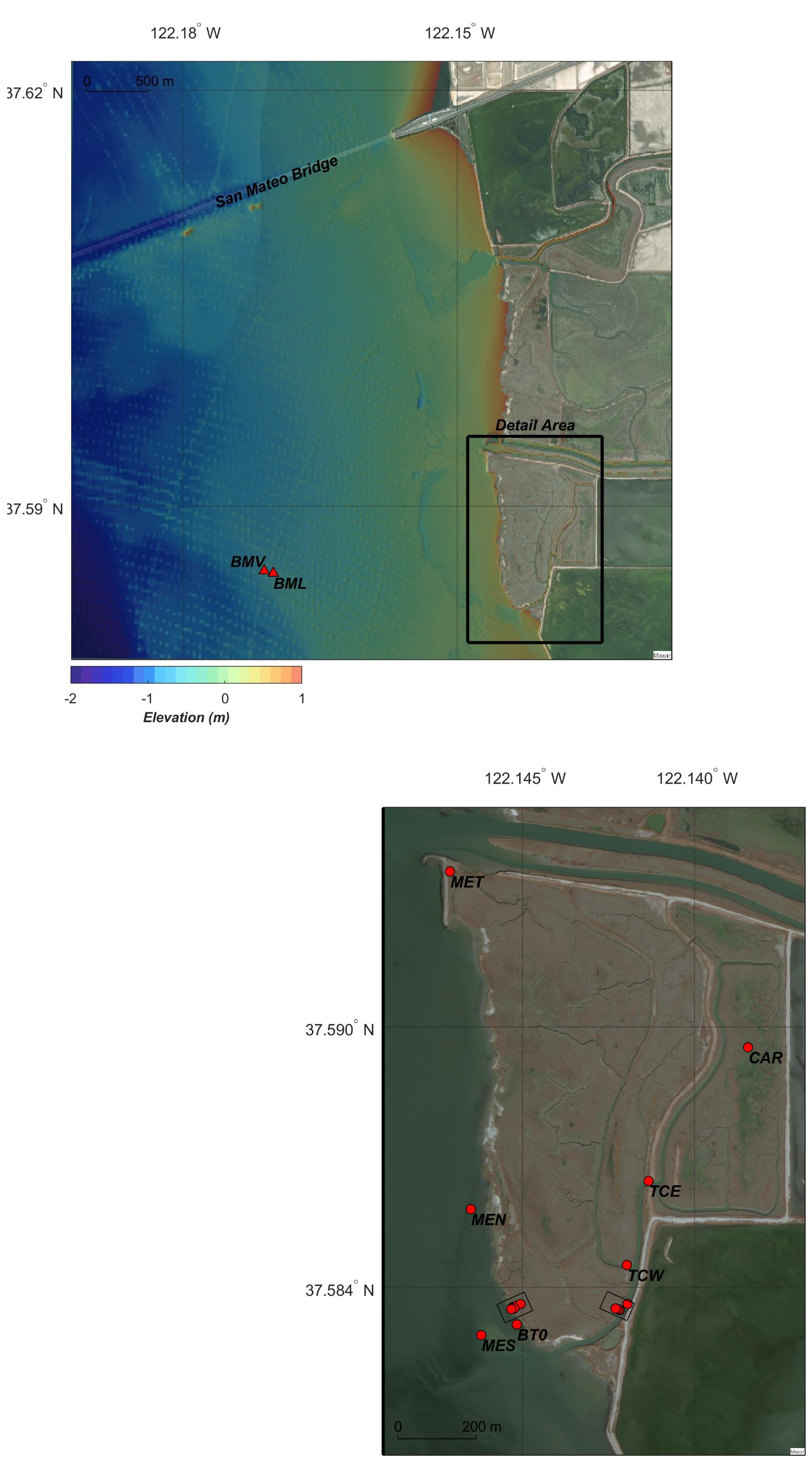
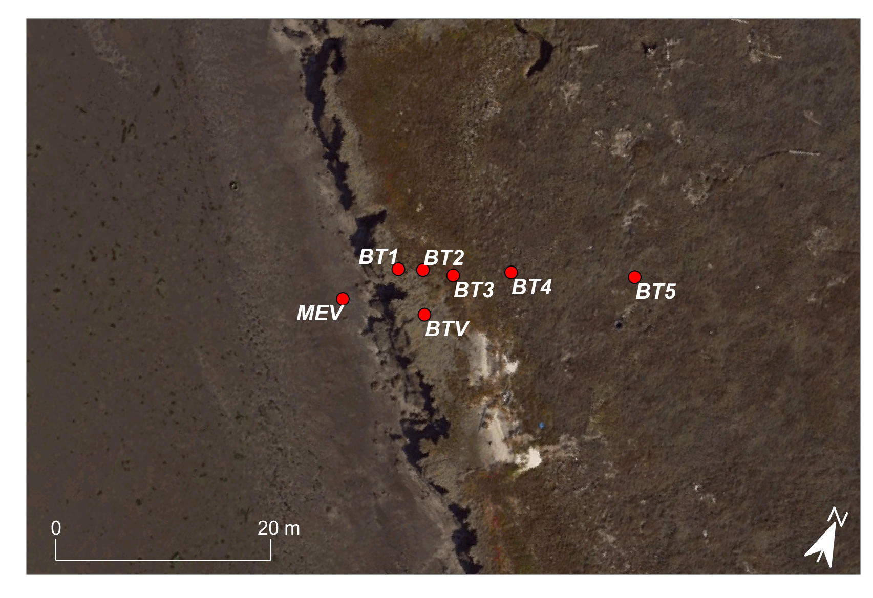
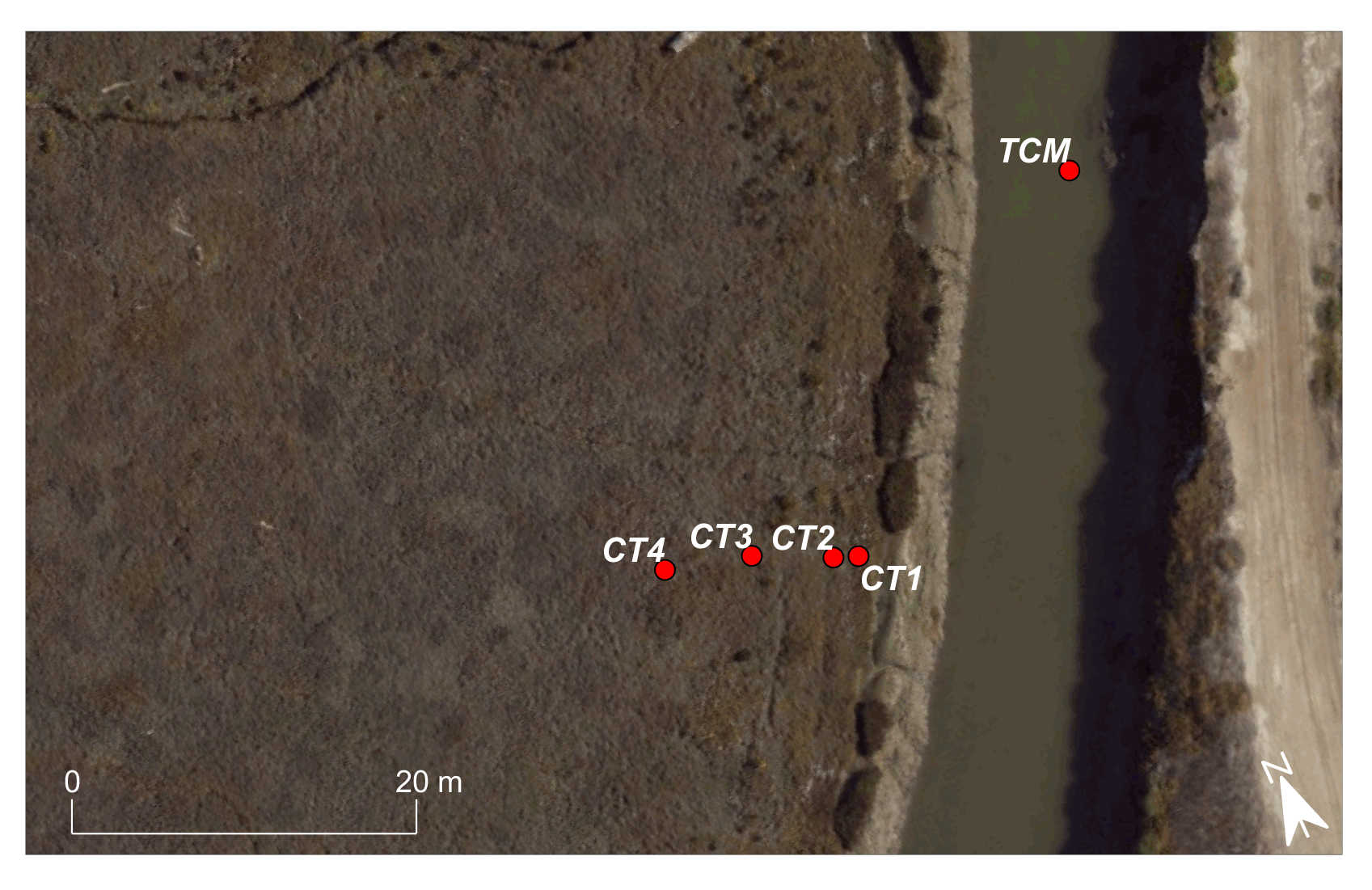
Hydrodynamic and sediment transport time-series data, including water depth, velocity, turbidity, conductivity, and temperature, were collected by the U.S. Geological Survey (USGS) Pacific Coastal and Marine Science Center in South San Francisco Bay and in the Whale's Tail South marsh in Eden Landing Ecological Reserve in Alameda County, CA in 2021 and 2022. Data files are grouped by data type and season (summer and winter). At Bay sites, instruments were deployed on small quadpods. In the tidal creek, instruments were attached to grates mounted directly on the sediment bed. Marsh sites consisted of one transect of six stations perpendicular to the bay-marsh interface, and a second transect perpendicular to a tidal creek. Note that marsh stations were positioned fairly high in the tidal frame (close to the mean higher-high water elevation), so they were inundated less than 10 percent of the time. Instruments at the Bay stations were inundated most of the time but were subaerial at low tide. Data are only valid when the instruments were submerged. Users are advised to assess data quality carefully, and to check metadata for instrument information, as platform deployment times and data-processing methods varied.
Data Files
WTS21_aq.zip - 3.8 MB - MD5:aee47703b88833aafe22a04e07296d2d
WTS21_ctd.zip - 587.9 KB - MD5:ee212115e37975777fbcd889820577bf
WTS21_ls.zip - 46.7 MB - MD5:26050008d60b1db0df2d4bafb035c56d
WTS21_met.zip - 57.6 KB - MD5:cb0da120748846462ae91ff01d826757
WTS21_pr.zip - 948.8 MB - MD5:ae85e090aac8f6b936df78d60e810fd6
WTS21_tp.zip - 1.1 MB - MD5:ca81bc13afb0aaea604e3970185e16cc
WTS21_tu.zip - 779.0 KB - MD5:7031583057ce04a77e1ca7a0232b4a75
WTS21_t.zip - 337.3 MB - MD5:74d73876cc6979f25a81966a1cd7c553
WTS21_vec_wv.zip - 490.1 KB - MD5:63ee79667f06ccaf7b457583cfe0eb48
WTS21_vec.zip - 1.1 GB - MD5:d3d1c57ac30848534bd5b2b6e649bd30
WTW21_aq.zip - 5.1 MB - MD5:1ac27cb035b48cb473c6b9a59a20ba1e
WTW21_ctd.zip - 618.9 KB - MD5:7f1f568944af2d94bbbccabbe9f85071
WTW21_ls.zip - 46.8 MB - MD5:ef486debcc3b2f9a230476d619c556da
WTW21_met.zip - 57.3 KB - MD5:3d1fbfe5f52429fbad343bc389b259ea
WTW21_pr.zip - 977.2 MB - MD5:489af0034607289b577069847b16f9ee
WTW21_tp.zip - 1.1 MB - MD5:98844b9721c0ddf540990280eaa1a5c7
WTW21_tu.zip - 926.3 KB - MD5:9686a9286bef30067c4f625cffd8423e
WTW21_t.zip - 249.4 MB - MD5:1109f988232eb1a7a6029889033ed464
WTW21_vec_wv.zip - 579.7 KB - MD5:4fd2ae71ac18f52f868d0806caedb056
WTW21_vec.zip - 1.1 GB - MD5:38932c7cba24bd318fa4b2dcf7d348e8
Other Data Access
Metadata Files
WT_timeseries_metadata.xml - 28.1 KB
WT_timeseries_metadata.txt - 27.1 KB
Support Files
Regression_constants_for_converting_turbidity_to_SSC(mg_per_L).csv - 1.2 KB
wt_study_site_bay_transect.png - 1.3 MB
wt_study_site_tidal_creek_transect.png - 1.2 MB
WTS_file_table.csv - 5.7 KB
WTW_file_table.csv - 4.6 KB
Location-Elevation Data
-
Topographic data from Whale's Tail marshes, South San Francisco Bay, California, 2021-2022
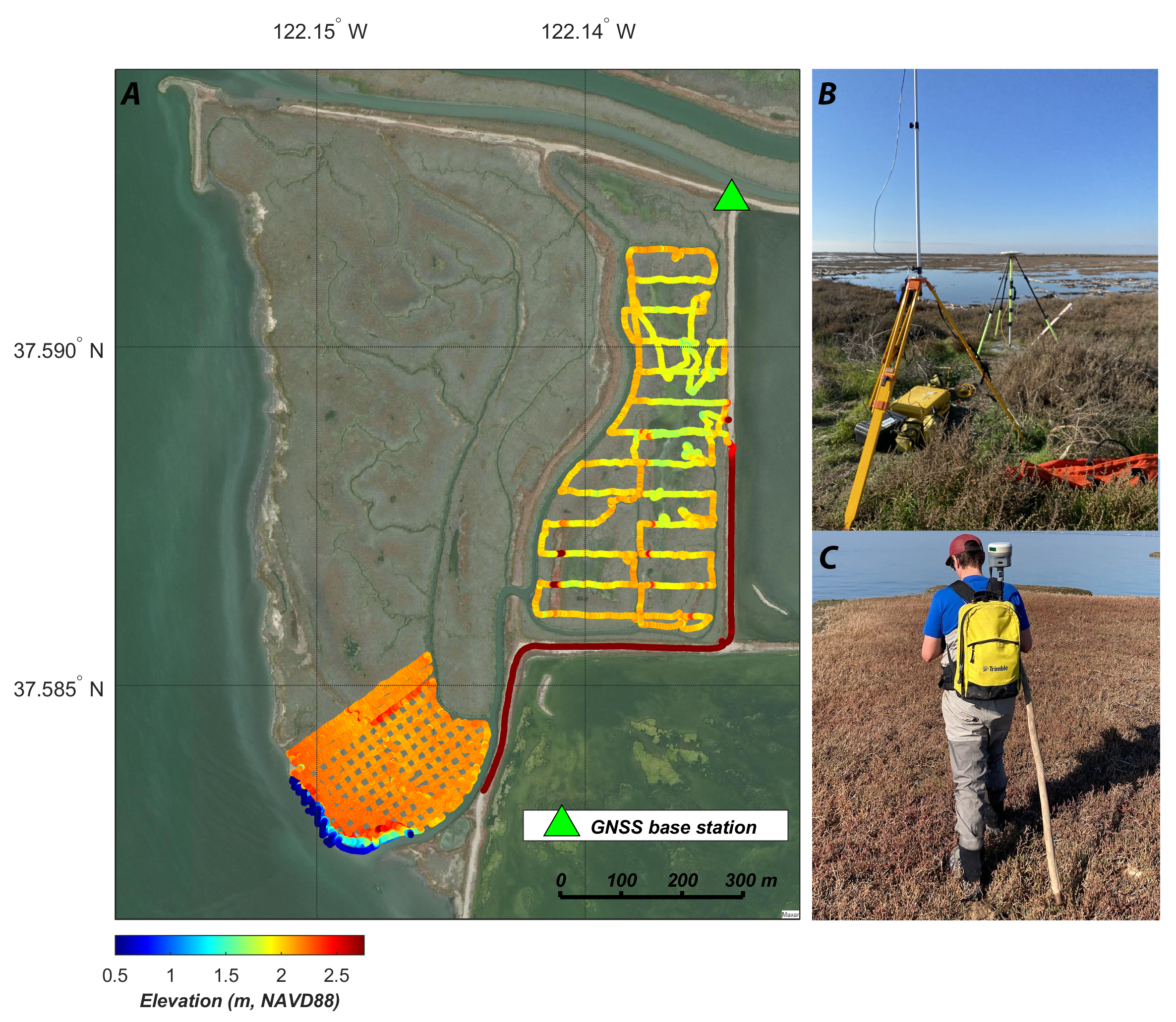
Topographic data were collected in the Whale's Tail marsh in southern San Francisco Bay between December 2021 and January 2022. The topographic data were acquired using global satellite navigation system receivers mounted on backpacks and hiked over the marsh surface.
Data Files
WT_topo.csv - 2.4 MB - MD5:58a6dcf1fc1dcaeb5ffaa42a41173817
Metadata Files
WT_topo_metadata.xml - 18.1 KB
WT_topo_metadata.txt - 17.6 KB
Environmental Data
-
Profiles of salinity, temperature, depth, turbidity, and distributions of particle size in suspension collected during four days in South San Francisco Bay, California, June 2021 to January 2022
Profiles of salinity, temperature, turbidity, and particle size distribution were collected by the U.S. Geological Survey (USGS) Pacific Coastal and Marine Science Center in South San Francisco Bay. Data were collected at depth intervals ranging between 0.5 and 2 m (depending on total water depth); sensors remained at each depth for 1-2 minutes. Each profile was collected from surface to bed, and the near-surface region was sampled again at the end of the profile to check steady-state conditions. Profiles were collected on 4 days: June 22, July 21, and December 3 of 2021, and on January 4, 2022 (UTC). Data files are grouped by season (summer or winter) and by instrument (CTD or LISST). No LISST data were collected in the winter. Users are advised to assess data quality carefully.
Data Files
WTS21_profiles_ctd.zip - 435.8 KB - MD5:4f59519f23d3fdb1cd588c6fa4d857a8
WTS21_profiles_lisst.zip - 1.2 MB - MD5:d216a975b7c0846d008f23a29e9edf0e
WTW21_profiles_ctd.zip - 650.1 KB - MD5:31c3b496e7ac71c3b016dad1f54ee89f
Metadata Files
WT21_profiles_metadata.xml - 13.3 KB
WT21_profiles_metadata.txt - 12.8 KB
-
Suspended sediment concentrations from water samples collected in South San Francisco Bay, California, and adjacent tidal creeks, Summer 2021
Water samples were collected in South San Francisco Bay and Whale's Tail South marsh tidal creeks from June 2021 through September 2021. The water samples were collected near pre-established USGS instrument moorings with a peristaltic pump, via a Niskin bottle, or directly with a sample bottle to analyze for suspended sediment concentration.
Data Files
WTS21_SSC_water_sample_data.csv - 17.2 KB - MD5:cfbfa5a9c7d960c7f5c618d9f6cf0ab7
Metadata Files
WTS21_SSC_metadata.xml - 18.4 KB
WTS21_SSC_metadata.txt - 18.0 KB
-
Suspended sediment concentrations from water samples collected in South San Francisco Bay, California, and adjacent tidal creeks, Winter 2021-2022
Water samples were collected in South San Francisco Bay and Whale's Tail South marsh tidal creeks from November 2021 through February 2022. The water samples were collected near pre-established USGS instrument moorings with a peristaltic pump, via a Niskin bottle, or directly with a sample bottle to analyze for suspended sediment concentration.
Data Files
WTW21_SSC_water_sample_data.csv - 17.6 KB - MD5:9df2bde76f5392b43b470bef9bd2ec09
Metadata Files
WTW21_SSC_metadata.xml - 18.6 KB
WTW21_SSC_metadata.txt - 18.2 KB
-
Percent Carbon content from suspended sediment in water samples collected Whale's Tail South marsh tidal creeks in South San Francisco Bay, California, Winter 2021-2022
Water samples were collected in Whale's Tail South marsh tidal creeks on December 3 and 6, 2021 and January 3, 2022 and processed to determine percent carbon in the samples. The water samples were collected near pre-established USGS instrument moorings with a Niskin bottle.
Data Files
WTW21_SSC_percentCarbon.csv - 2.3 KB - MD5:c4fb697f8ea758ce5a60dc4fc4f0e62d
Metadata Files
WTW21_SSC_percentCarbon_metadata.xml - 18.4 KB
WTW21_SSC_percentCarbon_metadata.txt - 17.9 KB
-
Percent sand and fines in suspended sediment from water samples from South San Francisco Bay, California, 2021
Water samples were collected in South San Francisco Bay adjacent to Whale’s Tail South marsh on three days from June through December 2021 to analyze for suspended-sediment concentration and the percent of sand and fines in suspended sediment.
Data Files
WT21_sand_break.csv - 1.2 KB - MD5:6f3c1f6b1606a671b9d5ded8c0ee0705
Metadata Files
WT21_sand_break_metadata.xml - 19.4 KB
WT21_sand_break_metadata.txt - 18.8 KB
Related Field Activities
- 2021-627-FA - View Details
- 2021-660-FA - View Details
Suggested Citation
Ferreira, J.C.T., Lacy, J.R., McGill, S.C., WinklerPrins, L.T., Nowacki, D.J., Stevens, A., and Tan, A., 2023, Hydrodynamic and sediment transport data from Whale's Tail marsh and adjacent waters in South San Francisco Bay, California 2021-2022: U.S. Geological Survey data release, https://doi.org/10.5066/P972R6AW.
Overview Image