Multibeam echosounder, video observation, and derived benthic habitat data offshore of south-central California in support of the Bureau of Ocean Energy Management Cal DIG I, offshore alternative energy project
By Guy R. Cochrane, Linda A. Kuhnz, Peter Dartnell, Lisa Gilbane, and Maureen A. Walton
https://doi.org/10.5066/P9QQZ27U
Dates
Published: Jan. 8, 2022
Data Collected: Aug. 27, 2018 – Sept. 27, 2019
Summary
Coastal and Marine Ecological Classification Standard (CMECS) geoform, substrate, and biotic component (also known as “biotope”) GIS products were developed for the U.S. Exclusive Economic Zone of south-central California motivated by interest in development of offshore wind energy capacity and infrastructure. The lead agency responsible for planning and leasing in the Exclusive Economic Zone, the U.S. Bureau of Ocean Energy Management (BOEM), funded the acquisition of these data to assess baseline conditions of the seafloor environment. Raw data from which these GIS products were developed include 8,234 km2 of bathymetry and backscatter data acquired using a multibeam echosounder (MBES) system during four surveys from 2016 to 2019, and underwater video acquired in 2019 using a Remotely Operated Vehicle (ROV). Nearly 120,000 annotations of organisms and their habitat were made from 25 video transects comprising 185 hours of underwater video. Derivatives of the MBES data (for example, induration, rugosity, and slope), and observations from the underwater video, were used to supervise the classification of the MBES data into 22 geoforms, 6 substrate types, 28 modifier groups, and 16 biotopes following the Coastal and Marine Ecological Classification Standard (CMECS). In total, 2,714 km2 of seafloor were successfully assigned to biotopes. Some biotopes were assigned to separate areas spatially distant from the transects that define the biotope. Expected relationships between physical habitat and biota such as the number of species and the substrate induration and rugosity were verified. Slope is typically a predictive variable and was used in the classification of habitat, but the ground-truth used for biotic component analysis included very little steeply sloping area. Ground-truth ROV operations were reduced by the sea state; additional ground-truth would improve the biotic results and increase confidence in the spatial distribution of classifications reported here.
Other Data
-
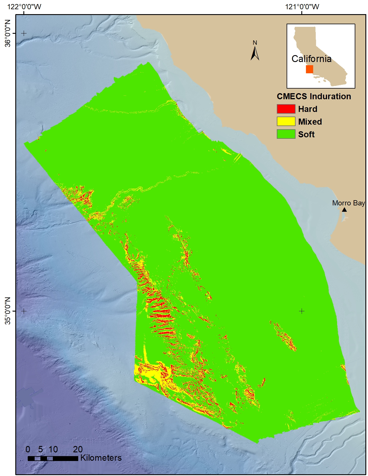
CMECS seafloor induration derived from multibeam echosounder data collected offshore of south-central California in support of the Bureau of Ocean Energy Management Cal DIG I, offshore alternative energy project
Seafloor induration (surface hardness) was derived from multibeam echosounder (MBES) and annotated underwater video data collected offshore of Morro Bay, California, from 2016 to 2020. MBES and underwater video data were collected in support of the U.S. Geological Survey (USGS)/Bureau of Ocean Energy Management (BOEM) California Deepwater Investigations and Groundtruthing I (Cal DIG I) project, under a collaboration with the National Oceanic and Atmospheric Administration (NOAA). Substrate observations from the underwater video were translated into Coastal and Marine Ecological Classification Standard (CMECS; Federal Geographic Data Committee, 2012) induration classes to use as training for a supervised classification of the MBES data. The induration raster is provided as a 10-meter resolution GeoTIFF.
Data Files
Cal_DIG_I_Induration.zip - 1.3 MB
Metadata Files
Cal_DIG_I_Induration_Metadata.xml - 19.5 KB
Cal_DIG_I_Induration_Metadata.txt - 19.0 KB
 Quick view of Cal DIG I seafloor induration (hardness) data showing hard (red), mixed (yellow), and soft (green).
 -
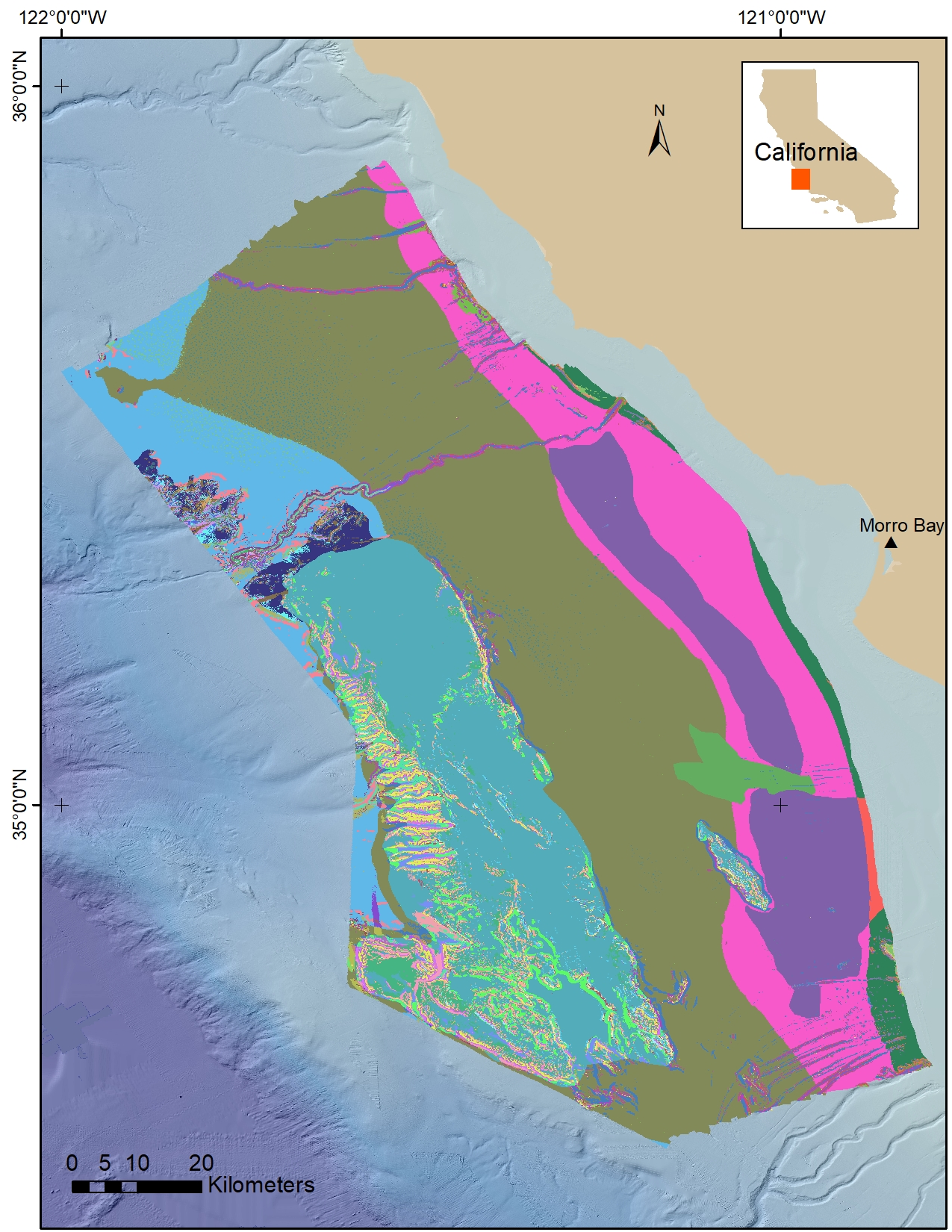
CMECS substrate, geoform, and biotic component polygons derived from multibeam echosounder data and underwater video observations collected offshore of south-central California in support of the Bureau of Ocean Energy Management Cal DIG I, offshore alternative energy project
These metadata describe Coastal and Marine Ecological Classification Standard (CMECS; Federal Geographic Data Committee, 2012) attributed polygons derived from multibeam echosounder acoustic bathymetry and backscatter intensity data, and from underwater video collected offshore of Morro Bay, California from 2016 to 2020. The polygons have CMECS substrate, geoform and biotic component attributes. Most of the data were collected in support of the U.S. Geological Survey (USGS)/Bureau of Ocean Energy Management (BOEM) California Deepwater Investigations and Groundtruthing I (Cal DIG I) project through collaborations with the National Oceanic and Atmospheric Administration (NOAA) and the Monterey Bay Aquarium Research Institute (MBARI).
Data Files
Cal_DIG_I_CMECS.zip - 35.8 MB
Metadata Files
Cal_DIG_I_CMECS_Metadata.xml - 25.2 KB
Cal_DIG_I_CMECS_Metadata.txt - 25.3 KB
 Quick view of Cal DIG I CMECS-classified biotopes.
Sonar Data
-
Multibeam acoustic-backscatter data collected offshore of south-central California in support of the Bureau of Ocean Energy Management Cal DIG I offshore alternative energy project
Multibeam acoustic-backscatter data were collected offshore of Morro Bay, California, from 2016 to 2019. The data were collected during five separate multi-agency surveys for the U.S. Geological Survey (USGS)/Bureau of Ocean Energy Management (BOEM) California Deepwater Investigations and Groundtruthing I (Cal DIG I) project, under a collaboration with the National Oceanic and Atmospheric Administration (NOAA), using Simrad 700 series hull-mounted multibeam echosounders. Data in 2017 and 2018 were acquired by the NOAA Hydrographic Vessel Rainier (surveys H1309, H13151, and H13152). The 2018 data acquired by the Ranier were collected during USGS field activity 2018-641-FA. Additional data were collected in 2019 by the NOAA Hydrographic Survey Vessel Fairweather (survey W00479). Data from the Scripps Institution of Oceanography R/V Sally Ride collected in 2016 (survey SR1604) were used to fill in a small gap in the NOAA data. The acoustic-backscatter data from the five surveys were combined into a single raster and are provided as a 10-meter resolution GeoTIFF.
Data Files
Cal_DIG_I_Backscatter_10m.zip - 239.9 MB
Metadata Files
Cal_DIG_I_Backscatter_10m_Metadata.xml - 15.0 KB
Cal_DIG_I_Backscatter_10m_Metadata.txt - 14.7 KB
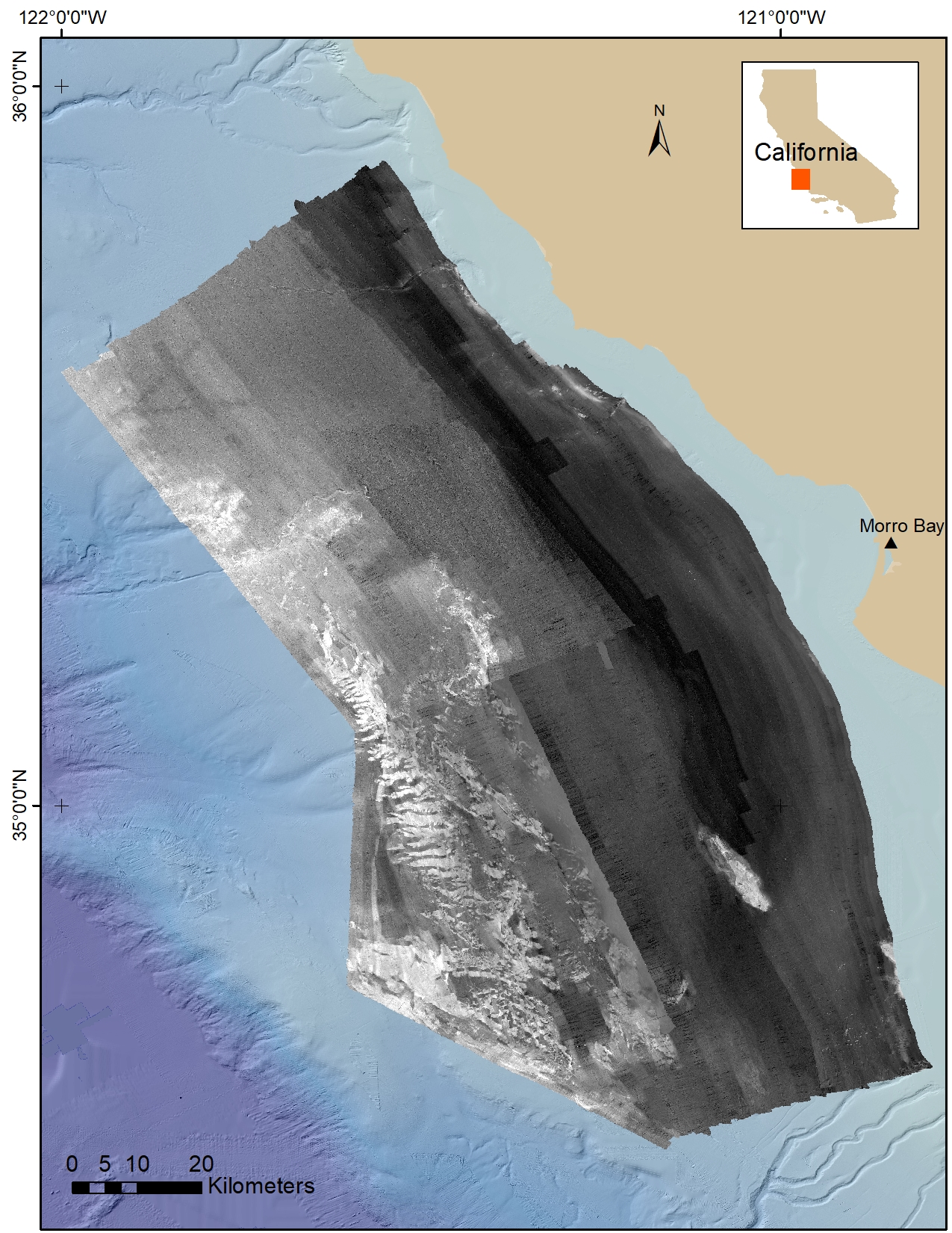
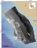 Quick view image of Cal DIG I backscatter intensity data.
 -
Multibeam bathymetry data collected in four surveys offshore of south-central California in support of the Bureau of Ocean Energy Management Cal DIG I offshore alternative energy project
Multibeam acoustic-bathymetry data were collected offshore of Morro Bay, California, from 2016 to 2019. The data were collected during five separate multi-agency surveys for the U.S. Geological Survey (USGS)/Bureau of Ocean Energy Management (BOEM) California Deepwater Investigations and Groundtruthing I (Cal DIG I) project, under a collaboration with the National Oceanic and Atmospheric Administration (NOAA), using Simrad 700 series hull-mounted multibeam echosounders. Data in 2017 and 2018 were acquired by the NOAA Hydrographic Vessel Rainier (surveys H1309, H13151, and H13152). The 2018 data acquired by the Ranier were collected during USGS field activity 2018-641-FA. Additional data were collected in 2019 by the NOAA Hydrographic Survey Vessel Fairweather (survey W00479). Data from the Scripps Institution of Oceanography R/V Sally Ride collected in 2016 (survey SR1604) were used to fill in a small gap in the NOAA data. The acoustic-backscatter data from the five surveys were combined into a single raster and are provided as a 10-meter resolution GeoTIFF.
Data Files
Cal_DIG_I_Bathymetry_10m.zip - 285.8 MB
Metadata Files
Cal_DIG_I_Bathymetry_10m_Metadata.xml - 15.0 KB
Cal_DIG_I_Bathymetry_10m_Metadata.txt - 14.8 KB
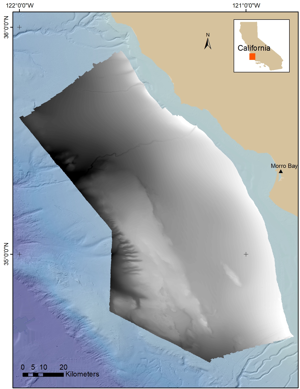
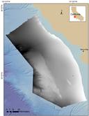 Quick view shaded-relief image of Cal DIG I bathymetry data.
Visual Identification Data
-
Physical, environmental, and biotic observations derived from underwater video collected offshore of south-central California in support of the Bureau of Ocean Energy Management Cal DIG I offshore alternative energy project
Physical, environmental, and biotic observations were derived from underwater video collected by the Monterey Bay Aquarium Research Institute (MBARI) using remotely operated vehicles (ROVs) offshore of Morro Bay, California. The data were acquired during three separate surveys in 2019 in support of the U.S. Geological Survey (USGS)/Bureau of Ocean Energy Management (BOEM) California Deepwater Investigations and Groundtruthing I (Cal DIG I) project. Transect information developed to analyze the data for biotopes (as described in Kuhnz and others, 2021) and the resulting biotope numbers are included in the point data.
A joint USGS-BOEM-MBARI cruise, which took place from 19-26 September 2019 on the R/V Bold Horizon (USGS field activity 2019-642-FA), focused on conducting biological surveys using MBARI's MiniROV (dives M137-148). Additional surveys were conducted from 02-14 February 2019 (dives D1120-1131) and from 01-11 November 2019 (dives D1202-1217) using MBARI's R/V Western Flyer and ROV Doc Ricketts. The ROV-video surveys were designed and conducted to collect video ground-truth information about substrate and biota.Data Files
Cal_DIG_I_Biotic_Component.csv - 6.7 MB
Metadata Files
Cal_DIG_I_Biotic_Component_Metadata.xml - 29.5 KB
Cal_DIG_I_Biotic_Component_Metadata.txt - 30.1 KB
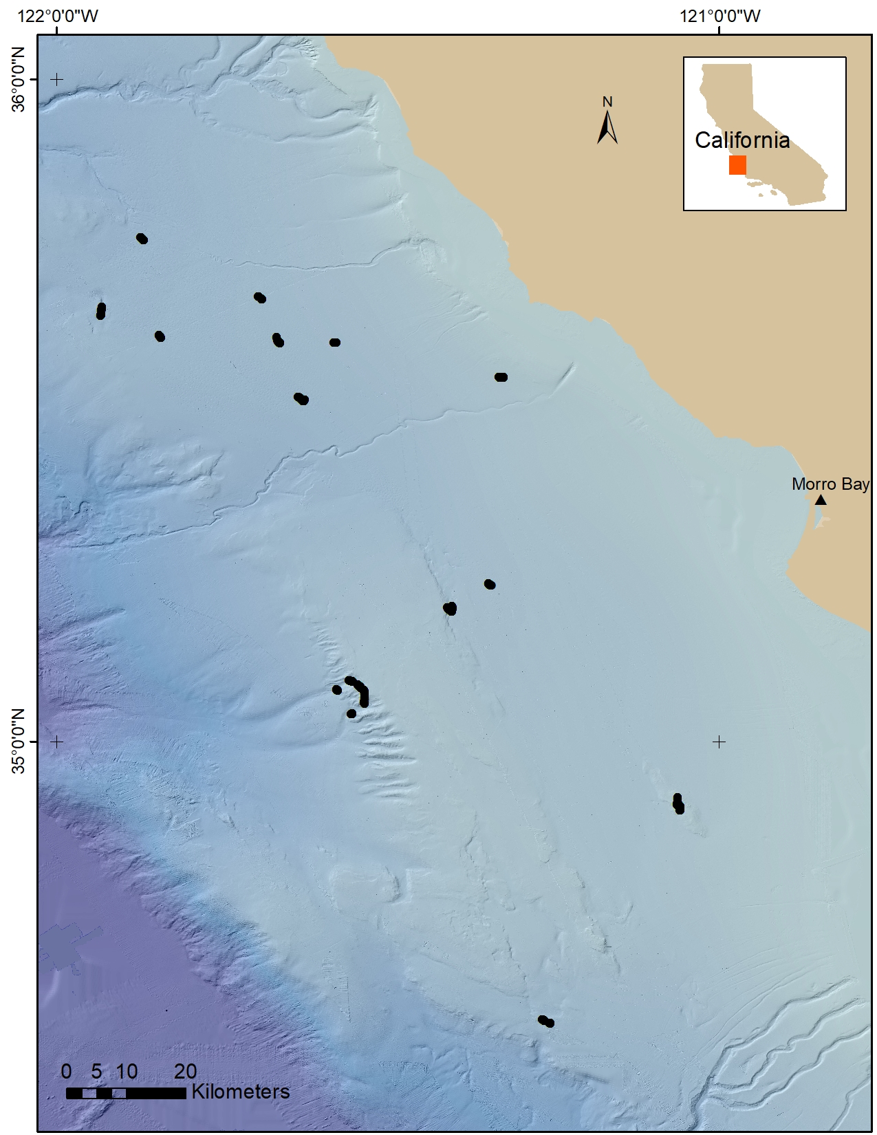
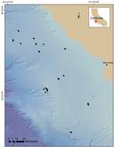 Quick view of Cal DIG I biotic observation locations.
 -
Physical, environmental, and substrate observations derived from underwater video collected offshore of south-central California in support of the Bureau of Ocean Energy Management Cal DIG I offshore alternative energy project
Physical, environmental, and substrate observations were derived from underwater video collected by the Monterey Bay Aquarium Research Institute (MBARI) using remotely operated vehicles (ROVs) offshore of Morro Bay, California. A majority of the data were acquired during three separate surveys in 2019 in support of the U.S. Geological Survey (USGS)/Bureau of Ocean Energy Management (BOEM) California Deepwater Investigations and Groundtruthing I (Cal DIG I) project. Additional observations from underwater video data collected by the Ocean Exploration Trust's E/V Nautilus in 2020 are also included. Slope, rugosity, and depth information derived from multibeam echosounder (MBES) bathymetry data, and induration (an indication of substrate hardness) information, are also included in the point data.
A joint USGS-BOEM-MBARI cruise, which took place from 19-26 September 2019 on the R/V Bold Horizon (USGS field activity 2019-642-FA), focused on conducting biological surveys using MBARI's MiniROV (dives M137-148). Additional surveys were conducted from 02-14 February 2019 (dives D1120-1131) and from 01-11 November 2019 (dives D1202-1217) using MBARI's R/V Western Flyer and ROV Doc Ricketts. The ROV-video surveys were designed and conducted to collect video ground-truth information about substrate and biota. MBARI-acquired video was analyzed by MBARI. Analysis of Nautilus video data was done by the USGS.Data Files
Cal_DIG_I_Substrate_Component.csv - 813.8 KB
Metadata Files
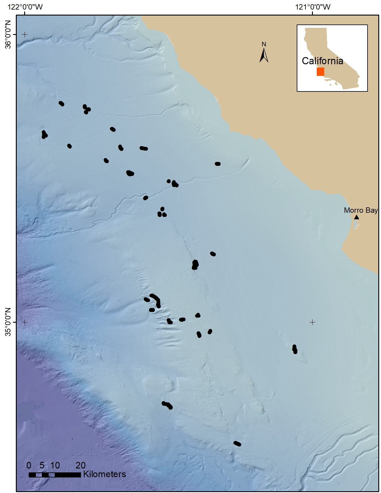
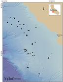 Quick view of Cal DIG I substrate observation locations.
Related Field Activities
- 2018-641-FA - View Details
- 2019-642-FA - View Details
Suggested Citation
Cochrane, G.R., Kuhnz, L.A., Dartnell, P., Gilbane, L., and Walton, M.A., 2022, Multibeam echosounder, video observation, and derived benthic habitat data offshore of south-central California in support of the Bureau of Ocean Energy Management Cal DIG I, offshore alternative energy project: U.S. Geological Survey data release, https://doi.org/10.5066/P9QQZ27U.
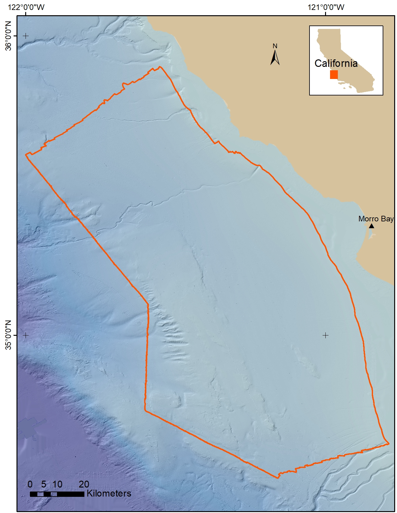
Overview Image