SQUID-5 structure-from-motion point clouds, bathymetric maps, orthomosaics, and underwater photos of coral reefs in Florida, 2019
By Gerry A. Hatcher, Jonathan A. Warrick, Andrew C. Ritchie, Evan T. Dailey, David G. Zawada, Christine J. Kranenburg, and Kimberly K. Yates
https://doi.org/10.5066/P9V7K7EG
Dates
Published: May 1, 2020
Data Collected: July 6, 2019 – July 16, 2019
Summary
The new structure-from-motion (SfM) quantitative underwater imaging device with five cameras (SQUID-5) was tested in July 2019 at Crocker Reef in the Florida Keys. The SQUID-5 was developed to meet the unique challenges of collecting SfM underwater imagery, including multiple cameras with different perspectives, accurate geographic locations of images, accurate and precise scaling of derived surface models, imagery coverage, and overlap geometry. Images were collected in tightly coupled quintets over varying benthic features, such as live and senile coral, sand waves, and rubble. The SQUID-5 platform was towed by the R/V Sallenger (8 m enclosed cabin ship) equipped with real-time acquisition monitoring. The primary purpose of the field experiment was to evaluate SQUID-5’s capabilities and limitations, and to determine its potential for generating data products of value to reef scientists. Survey locations were chosen based on their history of scientific investigations, including recently installed benthic survey monuments, and repeated studies of sediment elevation table (SET) stations. Images were collected over two SET stations to assess SfM product accuracy and precision. Images were also collected over areas of Crocker Reef to assess the SfM products ability to accurately map complex benthic topographies.
Imagery Data
-
Structure-from-Motion bathymetric maps from the Florida Keys, 2019
Structure-from-Motion (SfM) bathymetric maps were created using seafloor images collected using the new 5-camera system SfM Quantitative Underwater Imaging Device with Five Cameras (SQUID-5). Images were collected during July 2019 by towing the SQUID-5 in 3 to 4 meters of water off of Islamorada in the Florida Keys during 3 days. The five cameras were synchronized together and with a survey-grade Global Positioning System (GPS). Images were collected over diverse benthic settings, including living and senile reefs, rubble, and sand. Bathymetric maps were created from the photos using SfM photogrammetric software.
Data Files
SQUID5_Florida_BathymetricMaps.zip - 48.0 MB
Metadata Files
SQUID5_Florida_BathymetricMaps.xml - 17.6 KB
SQUID5_Florida_BathymetricMaps.txt - 17.0 KB
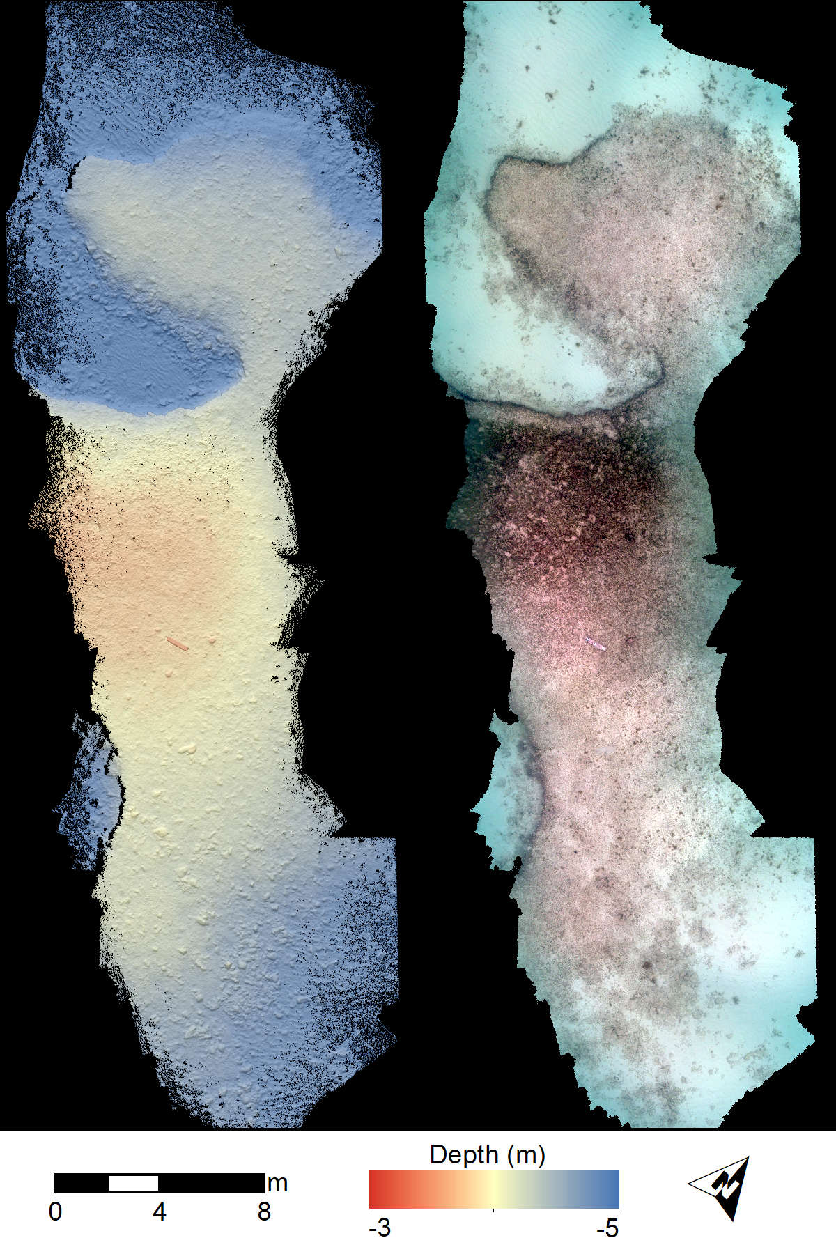
 Image map showing an example SfM bathymetry model (left) and orthomosaic (right)
 -
Structure-from-Motion orthophotos from the Florida Keys, 2019
Georeferenced orthophotos were created from structure-from-motion (SfM) data using seafloor images collected using the new 5-camera system SfM Quantitative Underwater Imaging Device with Five Cameras (SQUID-5). Images were collected in July 2019 by towing the SQUID-5 in 3 to 4 meters of water off of Islamorada in the Florida Keys during 3 days. The five cameras were synchronized together and with a survey-grade Global Positioning System (GPS). Images were collected over diverse benthic settings, including living and senile reefs, rubble, and sand. Orthomosaics were created from the photos using SfM photogrammetric software.
Data Files
SQUID5_Florida_Orthomosaics.zip - 170.3 MB
Metadata Files
SQUID5_Florida_Orthomosaics.xml - 17.8 KB
SQUID5_Florida_Orthomosaics.txt - 17.2 KB
 Example SfM orthomosaic
 -
Structure-from-Motion point clouds from the Florida Keys, 2019
Structure-from-Motion (SfM) point clouds were created from seafloor images collected using the new 5-camera system SfM Quantitative Underwater Imaging Device with Five Cameras (SQUID-5). Images were collected in July 2019 by towing the SQUID-5 in 3 to 4 meters of water off of Islamorada in the Florida Keys during 3 days. The five cameras were synchronized together and with a survey-grade Global Positioning System (GPS). Images were collected over diverse benthic settings, including living and senile reefs, rubble, and sand. Point clouds were created from the photos using SfM photogrammetric software.
Data Files
SQUID5_Florida_PointClouds.zip - 1.1 GB
Metadata Files
SQUID5_Florida_PointClouds.xml - 17.6 KB
SQUID5_Florida_PointClouds.txt - 17.0 KB
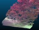 Perspective view of a SfM point cloud
 -
Structure-from-Motion underwater photos from the Florida Keys, 2019
Underwater photos were collected using a new 5-camera system, the Structure-from-Motion (SfM) Quantitative Underwater Imaging Device with Five Cameras (SQUID-5). Images were collected in July 2019 by towing the SQUID-5 in 3 to 4 meters of water off of Islamorada in the Florida Keys. The five cameras were synchronized together and with a survey-grade Global Positioning System (GPS). Images were collected over diverse benthic settings, including living and senile reefs, rubble, and sand. The images are presented here in zipped files grouped by Julian day. The SQUID-5 system records images in bitmap (.bmp) format to maintain the highest resolution and bit depth, and these were the files used in SfM processing. The zip files also contain portable network graphics (.png) files, an open-source format, and which include Exif metadata, including GPS date, time, and latitude and longitude, copyright, keywords, and other fields.
Data Files
SQUID5_Florida_UnderwaterPhotos.zip - 33.3 GB
Metadata Files
SQUID5_Florida_UnderwaterPhotos.xml - 15.9 KB
SQUID5_Florida_UnderwaterPhotos.txt - 15.4 KB
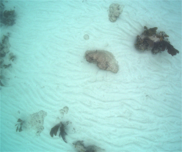
 Example underwater photo from one of the cameras


Related Field Activities
- 2019-323-FA - View Details
- 2019-630-FA - View Details
Suggested Citation
Warrick, J.A., Ritchie, A.C., Dailey, E.T., Hatcher, G.A., Kranenburg, C., Zawada, D.G., and Yates, K.K., 2020, SQUID-5 structure-from-motion point clouds, bathymetric maps, orthomosaics, and underwater photos of coral reefs in Florida, 2019: U.S. Geological Survey data release, https://doi.org/10.5066/P9V7K7EG
Overview Image
