SQUID-5 structure-from-motion point clouds, bathymetric maps, orthomosaics, and underwater photos of coral reefs in Florida, 2019
https://doi.org/10.5066/P9V7K7EG
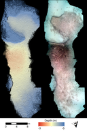
Structure-from-Motion bathymetric maps from the Florida Keys, 2019
Summary
Structure-from-Motion (SfM) bathymetric maps were created using seafloor images collected using the new 5-camera system SfM Quantitative Underwater Imaging Device with Five Cameras (SQUID-5). Images were collected during July 2019 by towing the SQUID-5 in 3 to 4 meters of water off of Islamorada in the Florida Keys during 3 days. The five cameras were synchronized together and with a survey-grade Global Positioning System (GPS). Images were collected over diverse benthic settings, including living and senile reefs, rubble, and sand. Bathymetric maps were created from the photos using SfM photogrammetric software.
Purpose
These bathymetric maps were produced to assess the accuracy, precision, and effectiveness of the new SQUID-5 camera platform.
Data Files
- SQUID5_Florida_BathymetricMaps.zip - 48.0 MB
Metadata Files
Suggested Citation
Warrick, J.A., Ritchie, A.C., Dailey, E.T., Hatcher, G.A., Kranenburg, C., Zawada, D.G., and Yates, K.K., 2020, SQUID-5 structure-from-motion point clouds, bathymetric maps, orthomosaics, and underwater photos of coral reefs in Florida, 2019: U.S. Geological Survey data release, https://doi.org/10.5066/P9V7K7EG

