Home - Images - Products - Data - Publications - Contact
Back to Glacier Perspective Views Overview
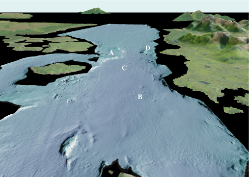
Figure 3. View looking south from over Willoughby Island toward Sitakaday Narrows (A) (arrow 3 on location map). The entrance to Glacier Bay at Icy Strait is in the distance. Iceberg wallow pits can be seen at (B), whereas ice gouges (C) extend south through and beyond Sitakaday Narrows. A bedrock knob (D) on the west side of the Narrows shoals to about 6 m (20 ft). The distance across the bottom of the image is about 5 km (3.1 miles), vertical exaggeration is 2X.
