Home - Images - Products - Data - Publications - Contact
Some products can be ordered from the USGS or downloaded online as PDF files. To order, please contact:
USGS Store
(888) ASK-USGS
https://store.usgs.gov/
|
California State Waters Map Series (USGS Data Series 781) Also see web site, “California Seafloor Mapping Program” (CSMP), Map Sheets and Pamphlets |
Includes: USGS Open-File Report and Scientific Investigations Map sheets (PDF) of northern California offshore map blocks (Offshore of Salt Point to Offshore of Monterey) plus southern California offshore map blocks (Offshore of Refugio Beach to Hueneme Canyon and Vicinity) | ||
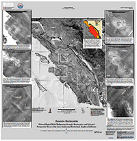
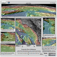
| Colored Shaded-Relief Bathymetry, Acoustic Backscatter, and Selected Perspective Views of the Inner Continental Borderland, Southern California (USGS Scientific Investigations Map 3324, 3 maps) | 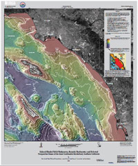 |
 |
 |
| Multibeam Bathymetry and Selected Perspective Views Offshore San Diego, California (USGS Scientific Investigations Map 2959, 2 maps) | |||
| Under the Golden Gate Bridge – Views of the Sea Floor Near the Entrance to San Francisco Bay, California (USGS Scientific Investigations Map 2917, 1 map) | |||
| Multibeam bathymetry and selected perspective views of Glacier Bay, Alaska (Water Resources Investigations Report: 03-4141, 2 maps) | |||
| Bathymetry and Selected Perspective Views Offshore Greater Los Angeles, California (Water Resources Investigations Report: 02-4126, 1 map) | |||
| 2000 Multibeam Sonar Survey of Crater Lake, Oregon: Data, GIS, Images, and Movies. USGS Digital Data Series, DDS-72, CD-ROM purchasing info: https://store.usgs.gov/product/112490 |
|||
| Bathymetry and Selected Perspective Views of Crater Lake, Oregon (Water Resources Investigations Report 01-4046, 2 maps) | |||
| Crater Lake Revealed (Geologic Investigations Series I-2790, 1 map)
Download PDF version at |
|||
| Bathymetry and Selected Perspective Views of Central San Francisco Bay, California (Water Resources Investigations Report 00-4164, 2 maps) | |||
| Bathymetry and Selected Perspective Views of Sea Floor North and West Maui, Hawaii (Water Resources Investigations Report: 00-4046, 2 maps) | |||
| Sea-Floor Images and Data from Multibeam Surveys in San Francisco Bay, Southern California, Hawaii, the Gulf of Mexico, and Lake Tahoe, California-Nevada (USGS Digital Data Series 55, CD-ROM)
Also available for free on the web at |
|||
| Shaded-relief bathymetric and backscatter maps of Santa Monica Margin, California (I-MAP I-2648, 2 maps) | |||
| Bathymetry and Selected Perspective Views of Lake Tahoe, California-Nevada (Water Resources Investigation Report 99-4043, 2 maps) | |||
| Visualizing the Geology of Lake Trout Spawning Sites, Northern Lake Michigan (Geologic Investigations Series I-2800)
Download PDF version at |
|||
| Under San Francisco Bay—A New View of the Floor of West-Central San Francisco Bay (Open-File Report 2001-90, Poster),
Download PDF version at |
|||
Related Products |
|||
| Selected Hydrographic Features of Lake Tahoe Basin and Surrounding Area, California and Nevada (Open-File Report 98-649, 1 sheet) | |||
