Home - Images - Products - Data - Publications - Contact
| |
 |
|
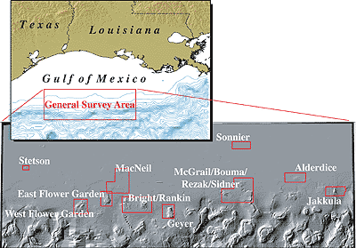
Jakkula Bank - Alderdice Bank - Sonnier Bank - Stetson Bank |
|
In 1997, the USGS, Seafloor Mapping Project conducted a series of test surveys in the Flower Garden Banks National Marine Sanctuary, Gulf of Mexico, approximately 200 miles south of the Texas-Louisiana border. The areas surveyed included, West Flower Garden Bank, East Flower Garden Bank, and Stetson Bank. These surveys collected high quality bathymetry and backscatter using a Kongsberg Simrad EM300 multibeam system. The test surveys collected such spectacular data that it was decided to publish the data. Following the publication of the high-resolution multibeam echosounder (MBES) images of the Flower Garden Banks area (Gardner et al., 1998), the Flower Gardens Banks National Marine Sanctuary (FGBNMS) and the Minerals Management Service (MMS) have been interested in additional MBES data in the area. A coalition of FGBNMS, MMS, and the US Geological Survey (USGS) was formed to map additional areas of interest in the northwestern Gulf of Mexico in 2002. The areas were chosen by personnel of the FGBNMS and the choice of MBES was made by the USGS. MMS and FGBNMS funded the mapping and the USGS organized the ship and multibeam systems through a Cooperative Agreement between the USGS and the University of New Brunswick. The objective of the cruise was to map 12 regions of interest to MMS and the FGBNMS, including, Alderdice, Sonnier, Geyer, Bright, Rankin (1 and 2), Jakkula, McNeil, Bouma, McGrail, Rezak, and Sidner Banks. For more information, see the Northwestern Gulf of Mexico Multibeam Cruise Report, To download the multibeam bathymetry and acoustic backscatter data and view the data in an ESRI ArcExplorer project see, Multibeam Mapping of Selected Areas of the Outer Continental Shelf, Northwestern Gulf of Mexico - Data, Images, and GIS. 2002. James V. Gardner, Jonathan D. Beaudoin, John E. Hughes Clarke, and Peter Dartnell. U.S. Geological Survey Open-File Report OF02-411. ReferencesGardner, J.V., Mayer, L.A., Hughes Clarke, J.E., and Kleinier, A., 1998, High-resolution multibeam bathymetry of East and West Flower Gardens and Stetson Banks, Gulf of Mexico. Gulf of Mexico Science, v. 16, p. 131-143. |
