Pacific Coastal and Marine Science Center
Bedform Sedimentology Site: “Bedforms and Cross-Bedding in Animation”
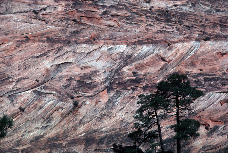
FIG. 51a. Structures formed by dunes with along-crest-migrating superimposed dunes; Navajo Sandstone (Upper Triassic? and Jurassic), Zion National Park, Utah. Both Figure 51a and Figure 51b show different vertical sections through the same beds.
RECOGNITION: In this photo the main bedform migrated from right to left, and the superimposed bedforms migrated away from the viewer. The troughs of the two intersecting sets of bedforms formed topographic depressions or scour pits, and migration of each of these scour pits through the plane of the outcrop produced one of the scallop-shaped sets of cross-beds. The sets are shaped like scallops, rather than complete troughs, because each scour pit partially reworked the set deposited by the adjacent scour pit that previously migrated through the outcrop plane. The sets were all truncated on their left sides, rather than randomly truncated, because all the scour pits were migrating down the trough of the main dune, which was migrating toward the left. The origin of this kind of structure is most evident in block diagrams, because those illustrations relate the scour- pit migration paths (in the horizontal sections) to the scallop- and trough-shaped sets visible in vertical sections. The structure in this outcrop appears most similar to the computer images in Figures 46H, K, and N. In the first of these computer-generated examples (Fig. 46H), the angle between the crestline of the main bedform and the resultant transport direction is 81degrees; the bedform is 9 degrees from being perfectly transverse to flow. In Figure 46K the angle between the crestline and the transport direction is 66 degrees (24 degrees from transverse), and in Figure 46N the angle is 13 degrees (77 degrees from transverse). The similar appearance of these differently formed structures demonstrates the difficulty of precise paleocurrent determinations. Figure 51b shows a second vertical section through the same beds. (The section in this figure is viewed from road level slightly off the right side of the photograph shown in Figure 51b.) The outcrop in this figure cuts across the axes of the scallop-shaped trough sets of cross- beds. In Figure 51b, the scallops are nearly undetectable, because the outcrop is nearly parallel to the trough axes; as shown in Figure 46, the scallops are not visible in vertical sections parallel to their axes.
