
The December 26, 2004 Indian Ocean Tsunami: Initial Findings on Tsunami Sand Deposits, Damage, and Inundation in Sri Lanka
Survey Site Locations and Photos
Kalmunai 2Click photo to see a larger image |
|
 Sand and bricks on top of this Post Office at Kalmunai were left by the tsunami. The height of the tsunami here was more than 4.75 m. Photograph courtesy of Phillip Liu, Cornell University. (larger image, 200 kb) |
 Tsunami sand and brick on top of the Post Office at Kalmunai. The top of this building is 4.75 m above ground level and about 7 m above sea level. (larger image, 190 kb) |
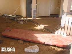 Sand and debris transported by the tsunami into the Post Office at Kalmunai. Outside the Post Office, there was localize erosion nearby and thick (>10 cm) sand deposits. (larger image, 124 kb) |
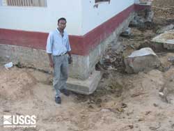 Localized scour at the base of the Post Office at Kalmunai was greater than 0.5 m. Note the large blocks of concrete that were moved by the tsunami. (larger image, 139 kb) |
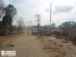 Road eroded by the tsunami at Kalmunai. The road is approximately 100 m from the shoreline. Tsunami-induced erosion was commonly observed at the edges of roads and at the base of structures. (larger image, 114 kb) |
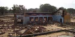 Nearly all the buildings within 500 m of the coast were destroyed in this part of Kalmunai. Photograph courtesy of Phillip Liu, Cornell University. (larger image, 139 kb) |
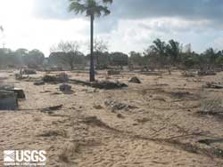 Flow direction indicators, here trees knocked down and bent over by the tsunami, indicated a strong onshore flow (235 degrees) at Kalmunai. Flow direction is important for determining what direction the tsunami travelled as it was modified by the nearshore underwater topography. This information is useful for ground-truthing tsunami inundation models. (larger image, 164 kb) |
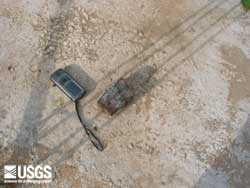
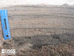 The tsunami deposit at Kalmunai is 12 cm thick and is made up of multiple layers. The brown sandy soil at the bottom of the photograph is pre-tsunami sediment. (larger image, 282 kb) |