Pacific Coastal and Marine Science Center
Natural Oil & Gas Seeps in California
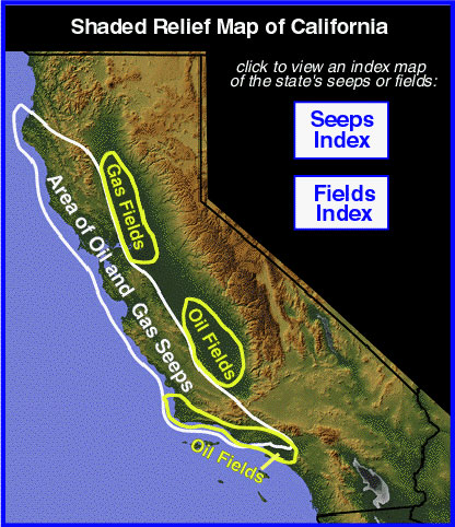
Most of California's natural oil and gas seeps are in the area circled in white on this shaded relief map. The state's major underground oil and gas fields (known from drilled wells) are in the three areas outlined on the map (labeled as "Fields"). Note that the seeps occur near the oil and gas oil fields. This is no coincidence.
The reason seeps are found close to major oil and gas fields is that most seeps are fed by these natural underground reservoirs. Just as springs are fed by underground reservoirs of water, oil and gas seeps are fed by underground reservoirs of oil and gas.
The low area running down the center of California is the Central Valley, California's famous agricultural belt. It is underlain by sedimentary rocks that are rich in petroleum and is home to the state's largest oil and gas fields. Oil and gas migrate upward from these underground fields to form the adjacent oil and gas seeps.
Click on the “Seeps Index” button or the “Fields Index” button to view a more detailed map of seeps or fields.
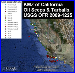 CA oil seeps and tarballs
Location and characteristics of samples analyzed for “Natural offshore seepage and related tarball accumulation on the California coastline; Santa Barbara Channel and the southern Santa Maria Basin; source identification and inventory” by T.D. Lorenson and others, 2009, U.S. Geological Survey Open-File Report 2009-1225; http://pubs.usgs.gov/of/2009/1225/
Samples are symbolized according to sample type (source rock, production oil, seep, unlocated seep, or tar) and chemometric tribe 1, 2, or 3 as identified by cluster analysis (0 not a tribe member). The specific chemometric family (1- to 3-digit code) and other sample attributes can be found by clicking on each individual sample identifier.
Click to download the .kmz file, which may be displayed in a virtual globe application like Google Earth: CAseeps100219.kmz
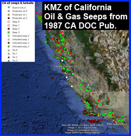 CA seeps
View a .kmz file that plots the seeps from the publication: Hodgson, S.F., 1987, Onshore oil and gas seeps in California: California Department of Conservation, Division of Oil and Gas, Publication No. TR26, 97 p.
Click to download the .kmz file, which may be displayed in a virtual globe application like Google Earth: seeps87.kmz
