Other ID: 67
Status: Completed
Organization(s): USGS, Woods Hole Coastal and Marine Science Center
Funding Program(s):
Principal Investigator(s): Bradford Butman
Affiliate Investigator(s):
Information Specialist(s):
Data Type(s): Environmental Data: CTD, Imagery: Photo, Location-Elevation: Navigation, Sampling: Biology, Sampling: Geology, Seismics: Boomer, Sonar: Sidescan, Sonar: Single Beam, Time Series: Mooring (physical oceanography)
Scientific Purpose/Goals: This cruise was part of a continuing study of currents and sediment transport on the United States East Coast Continental Shelf. Objectives were to: recover 1 tripod and 3 current moorings; deploy 4 tripods and 3 current moorings; repair/replace surface buoys; obtain grab samples at mooring locations, obtain gravity cores at selected sites; conduct temperature/salinity surveys and collect suspended matter samples for talc analyses; and conduct a sidescan survey of large-scale bedforms on Georges Bank.
Vehicle(s):
Start Port/Location: Woods Hole, MA
End Port/Location: Woods Hole, MA
Start Date: 1979-08-06
End Date: 1979-08-13
Equipment Used: Plessey CTD, Smith-MacIntyre grab, Gravity corer, Klein 531 sidescan, Boomer, Camera- deep sea, Northstar 6000 LORAN-C, Single channel hydrophone, 12 kHz, Bottom platform
Information to be Derived: Time series data; Samples and chemical analysis; Grain size analysis; Suspended sediment concentrations; Sea floor map;
Summary of Activity and Data Gathered: Moorings recovered: 4; Georges Bank: #171 (deployed FA 79002 OCEANUS 56 Mar. 6-15, 1979); 174 and 175 (both deployed FA 79004 OCEANUS 58 Mar. 27-29, 1979); Mid-Atlantic: #172 (deployed FA 79002 OCEANUS 056 Mar. 6-15, 1979). Moorings deployed: 7; Georges Bank: #176 (recovered FA 79035 OCEANUS 77 Dec. 13-20, 1979); 178 (recovered FA 80001 WHITEFOOT Jan. 3-23, 1980); 181 and 182 (both recovered FA 79035 OCEANUS 77 Dec. 13-20, 1979); Mid-Atlantic: #177 (recovered FA 80001 WHITEFOOT Jan. 3-23, 1980), 179 (recovered FA 79035 OCEANUS 77 Dec. 13-20, 1979), 180 (recovered FA 80001 WHITEFOOT Jan. 3-23, 1980, surface buoy gone, mooring lost). Klein Sidescan, Uniboom survey: Georges Shoal, Little Georges, Great South Channel; Hydrographic stations: 59; XBT: 28; CTD: 23; Surface salinity: 47; Grab samples: 12; Gravity cores: 3; Suspended matter (talc): 15.
Staff: Bradford Butman, Mary E. Hastings, John Moody, Carol M. Parmenter, Stephanie Pfirman, Richard Rendigs, William J. Strahle, John West, Marlene Noble
Affiliate Staff:
Jim Howley
Nicholas Lefteriou; James Willingham - USGS-Corpus Christi
Notes: Original Center People field contained: Brad Butman - Ch. Sci.; Jim Howley, Nicholas Lefteriou, John Moody, Marlene Noble, Carol Parmenter, Stephanie Pfirman, Richard Rendigs, Polly Shoukimas, William Strahle, John West.
Location:
Mid-Atlantic Shelf, Mud Patch, Georges Bank, Georges Shoal, Little Georges, Great South Channel, United States, North America, North Atlantic;
| Boundaries | |||
|---|---|---|---|
| North: 41.9095455 | South: 38.4229917 | West: -73.81592977 | East: -67.4805517 |
Platform(s):
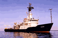
 Oceanus |
Moody, J.A., and Butman, B., 1980, Semidiurnal bottom pressure and tidal currents on Georges Bank and in the Mid-Atlantic Bight: U.S. Geological Survey Open-File Report 80-1137, https://doi.org/10.3133/ofr801137.
Moody, J.A., Butman, B., Beardsley, R.C., Brown, W.S., Daifuku, P., Irish, J.D., Mayer, D.A., Mofjeld, H.O., Petrie, B., Ramp, S., Smith, P., and Wright, W.R., 1984, Atlas of tidal elevation and current observations on the Northeast American continental shelf and slope: U.S. Geological Survey Bulletin 1611, https://doi.org/10.3133/b1611.
Twichell, D.C., McClennen, C.E., Butman, B., 1981, Morphology and processes associated with the accumulation of the fine-grained sediment deposit on the southern New England shelf: Journal of Sedimentary Petrology, v. 51 no. 1, doi: 10.1306/212F7C6B-2B24-11D7-8648000102C1865D.
| Title | Survey Equipment | Description |
|---|---|---|
| Cruise report | (document not focused on specific equipment) | Chief Scientist's daily log of ship movement, equipment and data acquisition notes, station locations and data acquired at each station, personnel activities, bridge log of navigation, and trackmaps. |
| Survey Equipment | Survey Info | Data Type(s) | Data Collected |
|---|---|---|---|
| Plessey CTD | --- | CTD | |
| Smith-MacIntyre grab | --- | Biology Geology | 1979-021-FA-SC-002 (CORE, GRAB samples) |
| Gravity corer | --- | Geology | 1979-021-FA-SC-001 (CORE, GRAB samples) |
| Klein 531 sidescan | --- | Sidescan | 1979-021-FA-SO-001 (microfilm of W/NAV) |
| Boomer | --- | Boomer | |
| Camera- deep sea | --- | Photo | 1979-021-FA-PH-001 (film collection of TRIPOD 179; 19780808-19791219) |
| Northstar 6000 LORAN-C | --- | Navigation | 1979-021-FA-LN-002 (Digital tape(s) of NV, ) 1979-021-FA-LN-002-01 (Navigation data) 1979-021-FA-LN-001 (Navigation trackline plot for field activity 79021) |
| Single channel hydrophone | --- | Air Gun / Water Gun Boomer Bubble Gun Sparker Sub Bottom Profiler | 1979-021-FA-SE-002 (microfilm of W/NAV) |
| 12 kHz | --- | Single Beam | 1979-021-FA-SE-001 ( Collection of paper record displays of seismic data( 12K) for lines ) |
| Bottom platform | --- | Mooring (physical oceanography) | 1979-021-FA-OM-001 (Georges Bank Sediment mooring data) |