Other ID: OC181, Leg 1
Status: Completed
Organization(s): USGS, Woods Hole Coastal and Marine Science Center
Funding Program(s):
Principal Investigator(s): Bradford Butman
Affiliate Investigator(s):
Information Specialist(s):
Data Type(s): Imagery: Photo, Sampling: Geology, Time Series: Mooring (physical oceanography)
Scientific Purpose/Goals: The OCEANUS cruise was part of a continuing study of the hydrography, circulation and sediment transport in the Gulf of Maine. The specific objectives of the cruise were to: 1) Conduct a detailed hydrographic survey of the Gulf of Maine; 2) Recover 2 moorings in the Northeast Channel; 3) Deploy 1 subsurface mooring in Rodgers Pass; and 4) Deploy instrumentation (3 tripods, 1 subsurface mooring and 3 surface buoys) in Massachusetts Bay.
Vehicle(s):
Start Port/Location: Woods Hole, MA
End Port/Location: Portsmouth, NH
Start Date: 1987-02-05
End Date: 1987-02-15
Equipment Used: Camera- deep sea, Grab sampler, Bottom platform
Information to be Derived: Time series data; Suspended sediment concentrations;
Summary of Activity and Data Gathered: Moorings deployed: 7 (#317, 318, and 319 recovered FA 87011 MARY LOUISE Apr. 8-10, 1987; #320, 321, and 322, recovered FA 87020 WHITE HEATH May 12, 1987; and #323 recovered this cruise. Moorings recovered: 4 (#323 deployed this cruise; UNH buoy adrift - recovered lower half; Brookhaven instrument package; surface buoy N1). Non-responsive mooring: 1 (#314 deployed FA 86017 GYRE Aug. 21 - Sep. 2, 1986). CTD stations: 95; Suspended sediment samples: 282; Oxygen samples: 92.
Staff: Bradford Butman, Mary E. Hastings, John Moody, Richard Rendigs, William J. Strahle
Affiliate Staff:
Wendell Brown (UNH); Karen Garrison (UNH); Daniel Howard (UNH); Charlie Flagg (Brookhaven Nat'l Lab); William Behrens (Brookhaven Nat'l Lab); Andrew Eliason (Eliason Data Services); Dana Wiese (WHOI)
Notes: Original Center People field contained: Brad Butman (Ch. Sci.), John Moody, Richard Rendigs, Mary Polly Shoukimas, William Strahle.
Location:
Rodgers Pass, Wilkinson Basin, Jordan Basin, Northeast Channel, Boston Harbor, Massachusetts Bay, Massachusetts, Gulf of Maine, United States, North America, North Atlantic;
| Boundaries | |||
|---|---|---|---|
| North: 43.5 | South: 41.2 | West: -71 | East: -65.5 |
Platform(s):
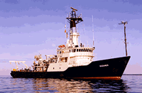
 Oceanus |
Moody, J.A., Butman, B., Shoukimas, P., Donoghue, T.G., 1990, Hydrography of the Gulf of Maine and Massachusetts Bay, Data Report for R/V OCEANUS cruise 181, 5-15 February 1987: U.S. Geological Survey Open-File Report 90-350, https://doi.org/10.3133/ofr90350.
| Title | Survey Equipment | Description |
|---|---|---|
| Cruise report | (document not focused on specific equipment) | Chief Scientist's cruise report including objectives, personnel, summary, daily narrative, tabulated information, trackmap, table of hydrographic station locations, meteorological observations, and navigation log. |
| Survey Equipment | Survey Info | Data Type(s) | Data Collected |
|---|---|---|---|
| Camera- deep sea | --- | Photo | 1987-005-FA-PH-001 (film collection of TRIPOD 319; 19870207-19870400) |
| Grab sampler | --- | Biology Geology | 1987-005-FA-SC-001 (GRAB, TRAP samples) |
| Bottom platform | --- | Mooring (physical oceanography) | 1987-005-FA-OM-001 (Mass Bay - West mooring data) |