Other ID: none
Status: Completed
Organization(s): USGS, Woods Hole Coastal and Marine Science Center
Funding Program(s):
Principal Investigator(s): John Bratton
Affiliate Investigator(s):
Information Specialist(s): John Bratton
Data Type(s): Environmental Data: Radon, Seismics: Sub Bottom Profiler, Location-Elevation: Navigation
Scientific Purpose/Goals: Reconnaissance-level surveying of submarine groundwater discharge indicators in lower Potomac River Estuary and western shore of Chesapeake Bay.
Vehicle(s):
Start Port/Location: Solomons, MD
End Port/Location: Solomons, MD
Start Date: 2006-09-05
End Date: 2006-09-09
Equipment Used: RAD7 radon detection instrument, Knudsen 1600 USB 1.2 kW with 2 Massa transducers (3.5 kHz), DGPS
Information to be Derived:
Summary of Activity and Data Gathered: 4 September, Bratton drives gear down from Woods Hole and Crusius flies down to scout area; 5 September, Worley, Foster, Erban arrive in Solomons, set up gear on boat, troubleshoot; 6 September, seismics/CRP/radon mapping from mouth of Patuxent River into Potomac River and St. Mary's River to Dennis Pt. Marina (lines #1-6), set up RAD7 and YSI for radon time series at marina, PM Cross arrives; September 7, surveys with all systems up Maryland shore of Potomac mainstem and zigzag back downstream (lines # 7-19); September 8, surveys with all systems up part of MD shore and mostly VA shore with final crossing back north (lines # 20-26), transit back to Solomons with 5 mid-channel (Potomac) radium samples and YSI profiles, demobe gear from boat; September 9, Crusius and Bratton back to Dennis Pt. Marina in AM to collect time-series gear and four groundwater samples, others head to airport, later Crusius to airport and Bratton drives pickup and trailer with gear back to Woods Hole.
Staff: John Bratton, VeeAnn Cross, John Crusius, Laura Erban, David Foster, Charles Worley
Affiliate Staff:
Joya Blix
first mate
Notes: Additional cruise on Chesapeake Eastern Shore likely in summer 2007. Original Center People field contained: John Bratton, Co-chief scientist; John Crusius, Co-chief scientist; VeeAnn Cross, navigation; Chuck Worley, electrical resistivity; Dave Foster, seismics; Laura Erban, contract geochem tech.
Project = Coastal Groundwater Systems, Coastal Groundwater Systems
Location:
Maryland, Potomac River estuary, Chesapeake Bay, United States, North America, North Atlantic;
| Boundaries | |||
|---|---|---|---|
| North: 39 | South: 37 | West: -77.5 | East: -75.5 |
Platform(s):
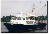
 Kerhin |
Bratton, J.F., 2007, The importance of shallow confining units to submarine groundwater flow, in Sanford, W., Langevin, C., Polemio, M., and Povinec, P., eds., A New Focus on Groundwater-Seawater Interactions: International Association of Hydrological Sciences, v. 312.
Bratton, J.F., 2010, The three scales of submarine groundwater flow and discharge across passive continental margins: The Journal of Geology, v. 118 no. 5, doi: 10.1086/655114.
Cross, V.A., Foster, D.S., and Bratton, J.F., 2010, Continuous resistivity profiling and seismic-reflection data collected in 2006 from the Potomac River estuary, Virginia and Maryland: U.S. Geological Survey Open-File Report 2009-1151, URL: https://doi.org/10.3133/ofr20091151.
FAN 2006-018-FA has data viewable in the GeoMappApp/Virtual Ocean applications. To view this data in these applications go to http://www.geomapapp.org/ and http://www.virtualocean.org/. See the instructions for locating USGS data in these applications. You can also view the imagery created from the SEGY data at https://cmgds.marine.usgs.gov/images.php?cruise=2006-018-FA.
| Survey Equipment | Survey Info | Data Type(s) | Data Collected |
|---|---|---|---|
| RAD7 radon detection instrument | --- | Radon | 2006-018-FA-NL-002 (CD ROM disk of CHES POTOMAC, FIELD RADON, ) |
| Knudsen 1600 USB 1.2 kW with 2 Massa transducers (3.5 kHz) | --- | Sub Bottom Profiler | 2006-018-FA-SE-001 (Raw seismic data) 2006-018-FA Chirp SEG-Y (Published Chirp SEG-Y data) SEGY seismic data |
| DGPS | --- | Navigation | Nav data |