Other ID: R-34-08-MA
Status: Completed
Organization(s): USGS, Woods Hole Coastal and Marine Science Center
Funding Program(s):
Principal Investigator(s): Lawrence Poppe
Affiliate Investigator(s):
Information Specialist(s): Lawrence Poppe, Nancy K. Soderberg
Data Type(s): Location-Elevation: Navigation, Seismics: Boomer, Seismics: Sub Bottom Profiler
Scientific Purpose/Goals: Ground truth NOAA hydrographic survey H11346 of the entrance to Edgartown Harbor with seismic reflection. One day primarily employed the Uniboom system; one day primarily employed the Knudsen Chirp.
Vehicle(s):
Start Port/Location: Woods Hole, MA
End Port/Location: Woods Hole, MA
Start Date: 2008-08-18
End Date: 2008-08-20
Equipment Used: Knudsen CHIRP Sub-bottom Profiler, DGPS, Boomer, Single channel hydrophone
Information to be Derived:
Summary of Activity and Data Gathered: Equipment problems prevented data acquisition on August 18, but 57 km of Knudsen Chirp seismic reflection profiles and 17 km of Uniboom seismic reflection profiles were collected along tracklines on August 19-20.
Staff: David Foster, Thomas O'Brien
Affiliate Staff:
Notes: Original Center People field contained: Dave Foster (boat operator); Tom O'Brien (seismic specialist).
Project = Sea and Lake Floor Mapping: Data off Cape Cod, Sea and Lake Floor Mapping: Data off Cape Cod
Location:
Edgartown Harbor, Nantucket Sound, Martha's Vineyard, Massachusetts, United States, North America, North Atlantic;
| Boundaries | |||
|---|---|---|---|
| North: 41.44692967 | South: 41.38333465 | West: -70.55322035 | East: -70.43029747 |
Platform(s):
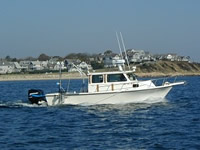
 Rafael |
Poppe, L.J., McMullen, K.Y., Foster, D.S., Blackwood, D.S., Williams, S.J., Ackerman, S.D., Moser, M.S., and Glomb, K.A., 2010, Geological interpretation of the sea floor offshore of Edgartown, Massachusetts: U.S. Geological Survey Open-File Report, https://doi.org/10.3133/ofr20091001.
FAN 2008-034-FA has data viewable in the GeoMappApp/Virtual Ocean applications. To view this data in these applications go to http://www.geomapapp.org/ and http://www.virtualocean.org/. See the instructions for locating USGS data in these applications. You can also view the imagery created from the SEGY data at https://cmgds.marine.usgs.gov/images.php?cruise=2008-034-FA.
| Survey Equipment | Survey Info | Data Type(s) | Data Collected |
|---|---|---|---|
| Knudsen CHIRP Sub-bottom Profiler | Knudsen 3200 | Sub Bottom Profiler | 2008-034-FA-SE-001-01 (Knudsen Chirp seismic reflection, GIS best basic version: processed SEG-Y data.) Chirp seismic data 2008-034-FA-SE-003 (Raw chirp and boomer hypack segy data.) 2008-034-FA-SE-001-02 (Knudsen Chirp seismic reflection profiles: 16 JPEG profiles from processed Knudsen data.) |
| DGPS | --- | Navigation | 2008-034-FA-LN-001-01 (Shotpoint and horizontal position extracted from SEG-Y trace headers for both Boomer and Knudson Chirp sub-bottom data.) |
| Boomer | --- | Boomer | |
| Single channel hydrophone | --- | Air Gun / Water Gun Boomer Bubble Gun Sparker Sub Bottom Profiler | 2008-034-FA-SE-002-01 (Boomer seismic reflection, GIS best basic version: SEG-Y data band passed filtered from 500 to 2000 Hz and AGC with 20 ms window length applied.) 2008-034-FA-SE-002-02 (Boomer seismic reflection profiles: 5 JPEG profiles from processed Boomer data.) Boomer (line 01b001) |