AKA: none
Other ID: A-1-98-SC
Status: Completed
Organization(s): USGS, Pacific Coastal and Marine Science Center
Funding Program(s): Southern California Seismic Hazards Project (MU271)
Principal Investigator(s): Bill Normark
Affiliate Investigator(s):
Information Specialist(s):
Data Type(s): Location-Elevation: Navigation, Seismics: Boomer, Seismics: Multichannel
Scientific Purpose/Goals: To identify active faults on shelf and inner basin slopes between Point Dume and Dana Point.
Vehicle(s):
Start Port/Location: Redwood City, CA
End Port/Location: Fish Harbor, CA
Start Date: 1998-08-09
End Date: 1998-08-23
Equipment Used: 24channel, navigation, Huntec
Information to be Derived: Define active faults and potentially active faults that would affect Los Angeles
Summary of Activity and Data Gathered: Obtain multichannel and high resolution seismic data throughout study area.
Staff: Bob Bohannon, Gita Dunhill, Larry Kooker, Walt Olson, Fred Payne, David Scholl, Ray Sliter, Hal Williams
Affiliate Staff:
Jane Laursen (Aarhus Univ. Denmark) - Geologist
Graham Standan (Geoforce) - Tech Rep
Lisa Schlender (Cascadia Research) - Marine Biologist
Jen Quan (Cascadia Research) - Marine Biologist
Kevin Blakley (Auriga) - Mate
Russ Brisendine (Auriga) - Engineer
Dick Corrigan (Auriga) - Captain
Marcus Ballweber (Auriga) - Mate
Paul Giron (Auriga) - Ab
Ricky Labrador (Auriga) - Chef
Notes:
Staff information imported from InfoBank
Bill Normark (USGS Western Region) - Chief Scientist
Ray Sliter (USGS Western Region) - Geophysicist
Bob Bohannon (USGS Western Region) - Geophysicist
Gita Dunhill (USGS Western Region) - Geologist
Dave Scholl (USGS Western Region) - Geologist
Jane Laursen (Aarhus Univ. Denmark) - Geologist
Fred Payne (USGS Western Region) - Electronic Tech
Larry Kooker (USGS Western Region) - Electronic Tech
Graham Standan (Geoforce) - Tech Rep
Hal Williams (USGS Western Region) - Mechanical Tech
Walt Olson (USGS Western Region) - Mechanical Tech
Lisa Schlender (Cascadia Research) - Marine Biologist
Jen Quan (Cascadia Research) - Marine Biologist
Kevin Blakley (Auriga) - Mate
Russ Brisendine (Auriga) - Engineer
Dick Corrigan (Auriga) - Captain
Marcus Ballweber (Auriga) - Mate
Paul Giron (Auriga) - Ab
Ricky Labrador (Auriga) - Chef
Location:
Southern California
| Boundaries | |||
|---|---|---|---|
| North: 34.00136 | South: 33.27702 | West: -118.927 | East: -117.64443 |
Platform(s):
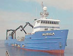
 Auriga |
Fisher, M., Normark, W., Langenheim, V., Calvert, A., and Sliter, R., 2005, Marine Geology and Earthquake Hazards of the San Pedro Shelf Region, Southern California: U.S. Geological Survey Professional Paper 1687, http://pubs.usgs.gov/pp/pp1687/.
Ryan, H.F., Conrad, J.E., Paull, C.K., McGann, M., 2012, Slip Rate on the San Diego Trough Fault Zone, Inner California Borderland, and the 1986 Oceanside Earthquake Swarm Revisited: Bulletin of the Seismological Society of America, v. 102 no. 6, pp. 2300–2312, doi: 10.1785/0120110317.
Ryan, H.F., Legg, M.R., Conrad, J.E., and Sliter, R.W., 2009, Recent faulting in the Gulf of Santa Catalina; San Diego to Dana Point; Earth science in the urban ocean; the Southern California continental borderland, in Lee, H.J., and Normark, W.R., eds., Earth Science in the Urban OceanâThe Southern California Continental Borderland: Geological Society of America Special Paper 454, pp. 291–315, doi: 10.1130/2009.2454(4.2).
Sliter, R.W., Normark, William R., and Gutmacher, Christina E., 2005, Multichannel seismic-reflection data acquired off the coast of southern California-Part A 1997, 1998, 1999, and 2000: U.S. Geological Survey Open-File Report 2005-1084, http://pubs.usgs.gov/of/2005/1084/.
FAN A198SC has data viewable in the GeoMappApp/Virtual Ocean applications. To view this data in these applications go to http://www.geomapapp.org/ and http://www.virtualocean.org/. See the instructions for locating USGS data in these applications. You can also view the imagery created from the SEGY data at https://cmgds.marine.usgs.gov/images.php?cruise=A198SC.
| Survey Equipment | Survey Info | Data Type(s) | Data Collected |
|---|---|---|---|
| 24channel | --- | Multichannel | survey information (multichanned 24 channel) Seismic FFID/Shot/CDP data a-1-98-sc.410_mcs (Provisional best file) Raw seismic shot point data a-1-98-sc.400 Multichannel data (stack data) |
| navigation | --- | Navigation | Global positioning system (GPS) data a-1-98-sc.060 Global positioning system (GPS) data a-1-98-sc.062 |
| Huntec | --- | Boomer | Raw depth (bathymetry) data a-1-98-sc.300 Raw depth (bathymetry) data a-1-98-sc.300_062 Raw depth (bathymetry) data a-1-98-sc.300_065 (Provisional best file) Global positioning system (GPS) data a-1-98-sc.063 Global positioning system (GPS) data a-1-98-sc.064 Eotvos/course/speed/distance data a-1-98-sc.075 survey information (hi res Huntec) NGDC MGD77 data |