USGS - science for a changing world

USGS Coastal and Marine Geology Program

Field Activity Details for field activity F686HW

View new CMGDS report form

AKA: none

Other ID: F-6-86-HW

Status: Completed

Organization(s):

Funding Program(s): Geological Long-Range Inclined Asdic (GLORIA) (MU116)

Principal Investigator(s): Peter Lipman, Bill Normark

Affiliate Investigator(s):

Information Specialist(s):

Data Type(s): Electro-Magnetic: Gravity, Electro-Magnetic: Magnetics, Environmental Data: Conductivity, Environmental Data: Temperature, Location-Elevation: Navigation, Seismics: Multichannel, Seismics: Sub Bottom Profiler, Sonar: Sidescan, Sonar: Single Beam

Scientific Purpose/Goals:

Vehicle(s):

Start Port/Location: Hilo, Hawaii

End Port/Location: Honolulu, Hawaii

Start Date: 1986-11-05

End Date: 1986-11-26

Equipment Used: gravity, 2channelairgun, 3.5khz, Gloriasidescan, gradiometer, expendablebatthermograph, integratednavigation, 10khz, tempsalinometer

Information to be Derived:

Summary of Activity and Data Gathered:

Staff: Jim Clarke

Affiliate Staff:
John Cherriman - IOS

Notes: physical data holdings
Associated cruises: F-5-86-HW F-6-86-HW F-3-88-HW F-4-88-HW F-5-88-HW F-6-88-HW F-10-88-HW F-12-89-HW F-13-89-HW F-1-90-HW F-2-90-HW F-6-91-CP F-10-91-HW Geological LOng-Range Inclined Asdic (GLORIA) GLORIA

Staff information imported from InfoBank
Bill Normark (USGS Western Region) - Chief Scientist
Peter Lipman (USGS Western Region) - Chief Scientist
John Cherriman - IOS
Jim Clarke - IOS

Location:

Hawaii

Boundaries
North: 20.7738 South: 15.9353 West: -158.566 East: -152.4335

Platform(s):

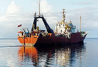
photo of Farnella
Farnella

Publications

Holcomb, R.T., Holmes, M.L., Lipman, P.W., Torresan, M.A., Normark, W.R., Clague, D.A., Moore, J.G., and Searle, R.C., 1988, Cenozoic submarine volcanism surrounding the Hawaiian Islands: , pp. 128–128.

Moore, J.G., Clague, D.A., Holcomb, R.T., Lipman, P.W., Normark, W.R., and Torresan, M.E.,, 1989, Prodigious submarine landslides on the Hawaiian Ridge: Journal of Geophysical Research, B, Solid Earth and Planets, v. 94 no. 12, pp. 17,465–17,484.

Moore, J.G., Normark, W.R., and Gutmacher, C.E., 1992, Major landslides on the submarine flanks of Mauna Loa Volcano, Hawaii: Landslide News, v. 6, pp. 13–16.

Moore, J.G., Normark, William R., and Szabo, B.J., 1990, Reef growth and volcanism on the submarine southwest rift zone of Mauna Loa, Hawaii: Bulletin of Volcanology, v. 52 no. 5, pp. 375–380.

Moore, J.G., Normark, W.R., and Gutmacher, C.E., 1990, Morphology of giant submarine debris-avalanche deposits, Mauna Loa, Hawaii: American Geophysical Union Eos, Transactions, v. 71 no. 43, pp. 1577–1577.

Moore, J.G., and Normark, W.R.,, 1990, Significance of major landslides on the Hawaiian Ridge: American Association of Petroleum Geologists Bulletin, v. 74 no. 6, pp. 991–992.

Moore, J.G., Bryan, Wilfred B., Beeson, Melvin H., and Normark, William R., 1995, Giant blocks in the South Kona Landslide, Hawaii: Geology, v. 23 no. 2, pp. 125–128.

Normark, W.R., Moore, J.G., Holcomb, R.T., Denlinger, R.P., Searle, R.C., Wilson, J.B., and Lipman, P.W., 1988, Humongous submarine slides off the Hawaiian Ridge: , pp. 127–128.

Paskevich, V.F., Wong, F.L., O'Malley, J.J., Stevenson, A.J., and Gutmacher, C.E., 2011, GLORIA sidescan-sonar imagery for parts of the U.S. Exclusive Economic Zone and adjacent areas: U.S. Geological Survey Open-File Report 2010-1332, http://pubs.usgs.gov/of/2010/1332/.

Torresan, M.E., Normark, W.R., Shor, A.N., and Moore, J.G., 1998, Classification of submarine failures surrounding the Hawaiian Islands: American Geophysical Union Eos, Transactions, v. 69 no. 44, pp. 1508–1508.

Portals/Viewers

FAN F686HW has data viewable in the GeoMappApp/Virtual Ocean applications. To view this data in these applications go to http://www.geomapapp.org/ and http://www.virtualocean.org/. See the instructions for locating USGS data in these applications. You can also view the imagery created from the SEGY data at https://cmgds.marine.usgs.gov/images.php?cruise=F686HW.

Data Acquired

Survey EquipmentSurvey InfoData Type(s)Data Collected
gravity --- Gravity
Raw gravity data from analog meter f-6-86-hw.111
Free Air Anomaly data f-6-86-hw.160
Survey information
Free Air Anomaly data f-6-86-hw.160_070 (Provisional best file)
NGDC MGD77 data - gravity
Gravity land tie data f-6-86-hw.140
Free Air Anomaly data f-6-86-hw.162
2channelairgun --- Multichannel
Raw seismic shot point data f-6-86-hw.400_070 (Provisional best file)
Raw seismic shot point data f-6-86-hw.400
Multichannel data (srt data) (Download SEG-Y files from National Archive of Marine Seismic Surveys (NAMSS))
Survey information
3.5khz --- Sub Bottom Profiler
Survey information
Gloriasidescan --- Sidescan
Gloria images (data in holdings)
F-6-86-HW-2_154368_GLORIA (scanned microfilm)
File list
Sidescan mosaic
Survey information
gradiometer --- Magnetics
Raw gradiometer data f-6-86-hw.241
Edited magnetics data f-6-86-hw.220
Survey information
Cooper-format gradiometer data f-6-86-hw.270
Edited gradiometer data f-6-86-hw.260
NGDC MGD77 data - Magnetics
Raw gradiometer data f-6-86-hw.241_070
Edited gradiometer data f-6-86-hw.260_070 (Provisional best file)
expendablebatthermograph --- Temperature
Station Information
integratednavigation --- Navigation
Eotvos/course/speed/distance data f-6-86-hw.070_degree
Best file with nav in ArcInfo E00 format
Eotvos/course/speed/distance data f-6-86-hw.070 (Provisional best file)
Integrated navigation (SINS) data f-6-86-hw.050
Lines
10khz --- Single Beam
Edited bathymetry data f-6-86-hw.332_070 (Provisional best file)
154368 310 02 18 LINE 001 - 330 01 MIN LINE 034
154368 310 04 08 LINE 001 - 311 04 MIN LINE 004
154369 310 04 08 LINE SOL 001 - 311 23 28 LINE EOL 006
154369 310 15 15 LINE BETWEEN 002+003 - 310 18 16 LINE 003
154369 310 19 08 LINE FROM 004A TO 004 - 311 05 01 LINE EOL 004
154368 311 04 13 LINE 004 - 313 08 53 LINE 011
154369 311 05 04 LINE BETWEEN 004+005 - 311 14 26 LINE EOL 5
154369 311 23 41 LINE SOL 007A - 312 19 40 LINE EOL 010
154369 312 19 48 LINE C-C TO 011A - 314 01 26 LINE 011
154369 315 19 MIN LINE C-C TO 014A - 316 05 10 LINE EOL 014
154369 316 05 15 LINE BETWEEN 014+015 - 317 18 25 LINE EOL 015
154369 316 05 22 LINE 015 - 317 18 25 LINE 015
154368 317 18 36 LINE BETWEEN 15+16 - 319 22 16 LINE EOL 18
154369 317 19 18 LINE 016A - 319 04 42 LINE EOL 016
154369 320 01 25 LINE PRE 020A - 320 06 14 LINE EOL 020
154369 320 19 04 LINE 023 - 322 10 44 LINE EOL 023
154368 324 06 16 LINE 025 - 326 15 59 LINE 026
154368 326 16 02 LINE 026 - 329 HR 25 LINE 030
154369 327 08 18 LINE 027A - 328 22 47 LINE EOL 029
154368 329 HR 28 LINE 030 - 330 02 19 LINE AFTER LINE 34
Edited bathymetry data f-6-86-hw.332
Raw depth (bathymetry) data f-6-86-hw.300
154369 320 06 19 LINE SOL 021 - 320 15 MIN LINE EOL 021
154369 320 15 03 LINE BETWEEN 021+022 - 320 18 50 LINE EOL 022
154369 322 10 50 LINE TO 024A - 323 21 51 LINE EOL 024
154369 325 21 23 LINE 026A - 327 08 05 LINE EOL 026
154369 323 22 10 LINE 025A - 325 21 11 LINE 025
154369 327 08 19 LINE 027A - 328 22 47 LINE EOL 029
154369 312 19 58 LINE 011A - 314 01 26 LINE 011
154369 315 11 04 LINE 3.5 KHZ BATHYMETRY 013 - 315 18 58 LINE 3.5 KHZ BATHYMETRY EOL 013
154369 314 01 39 LINE 012A - 315 10 54 LINE 012
154369 317 18 35 LINE C-C TO 016A - 319 04 42 LINE EOL 016
154369 319 04 47 LINE BETWEEN 016+017 - 319 09 01 LINE EOL 017
154369 319 04 46 LINE BETWEEN 016+017 - 319 09 01 LINE EOL 017
154369 319 22 23 LINE SOL 019 - 320 18 50 LINE EOL 022
154369 311 14 31 LINE BETWEEN 005+006 - 311 23 28 LINE EOL 006
154369 310 04 08 LINE 001 - 310 09 37 LINE 001
154369 312 16 35 LINE BETWEEN 009+010 - 312 19 40 LINE EOL 010
154368 313 08 56 LINE 011 - 315 14 50 LINE 013
154368 319 23 13 LINE 019 - 322 01 36 LINE 023
154369 328 22 52 LINE PRE 030 - 330 02 19 LINE POST 034
Survey information
154369 322 10 53 LINE BETWEEN 023+024 - 323 21 51 LINE EOL 024
154369 320 19 11 LINE 023 - 322 10 44 LINE 023
154369 325 21 27 LINE 026A - 327 08 05 LINE EOL 026
154369 328 22 52 LINE PRE 030 - 330 01 49 LINE POST 034
154369 315 19 29 LINE 014A - 316 05 10 LINE 014
154369 319 22 21 LINE 019 - 320 01 20 LINE EOL 019
154369 319 09 16 LINE 018 - 319 22 16 LINE EOL 018
NGDC MGD77 data - bathy
154369 312 07 47 LINE C-C TO 008 - 312 12 14 LINE 008
154368 315 14 54 LINE 013 - 317 18 25 LINE EOLIS
154369 310 09 39 LINE BETWEEN 001+002 - 310 15 14 LINE EOL 002
154369 311 23 41 LINE SOL 007A - 312 07 43 LINE EOL 007
154369 319 09 07 LINE C-C TO 018 - 319 22 16 LINE 018
154369 323 22 01 LINE 025A - 325 21 11 LINE EOL 025
154369 312 12 21 LINE 009 - 312 16 24 LINE EOL 009
154369 314 01 36 LINE PRE 012A - 315 10 54 LINE EOL 012
154369 315 11 04 LINE TWO-CHANNEL AIRGUN 013 - 315 18 58 LINE TWO-CHANNEL AIRGUN EOL 013
tempsalinometer --- Conductivity
Temperature

Accessibility FOIA Privacy Policies and Notices

U.S. Department of the Interior | U.S. Geological Survey
Questions or Comments? Contact CMGDS Team
https://cmgds.marine.usgs.gov