AKA: none
Other ID: M-1-64-EG
Status: Completed
Organization(s):
Funding Program(s): Earthquake Hazards Project (MU090)
Principal Investigator(s): George Plafker, James Case
Affiliate Investigator(s): L.R. Mayo
Information Specialist(s):
Data Type(s): Location-Elevation: Navigation
Scientific Purpose/Goals: Conducted an intensive shoreline survey around the Prince William Sound area to gather data on the nature of shoreline devastation following the 27 March 1964 Earthquake.
Vehicle(s):
Start Port/Location:
End Port/Location:
Start Date: 1964-05-20
End Date: 1964-06-10
Equipment Used: navigation
Information to be Derived: Land failure, slumps, slides, rock falls, heights of wave trim lines, direction of waves and inferred intensity of waves.
Summary of Activity and Data Gathered:
Staff:
Affiliate Staff:
Notes:
Staff information imported from InfoBank
George Plafker (USGS Western Region) - Chief Scientist
James Case - Chief Scientist
L.R. Mayo - Chief Scientist
Location:
Eastern Gulf of Alaska
| Boundaries | |||
|---|---|---|---|
| North: 61.75 | South: 57.25 | West: -144 | East: -132 |
Platform(s):
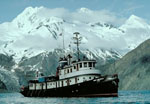 Don J. Miller II |
| Survey Equipment | Survey Info | Data Type(s) | Data Collected |
|---|---|---|---|
| navigation | --- | Navigation |
