The Digital Shoreline Analysis System (DSAS) version 3.0, an ArcGIS© Extension for Calculating Historic Shoreline Change
by E. Robert Thieler1, Emily A. Himmelstoss1, Jessica L. Zichichi2*, and Tara L. Miller3
1Coastal and Marine Geology Program, U.S. Geological Survey, Woods Hole, MA 02543
2Perot Systems - Science and Technology Solutions Group, Pembroke, MA 02349
* present address: GeoNet Systems www.geonetsystems.com
3Coastal and Marine Geology Program, U.S. Geological Survey, St. Petersburg, FL 33701
U.S. Geological Survey Open-file Report 2005-1304
2005
If you use the DSAS extension, please cite the following publication:
Thieler, E.R., Himmelstoss, E.A., Zichichi, J.L., and Miller, T.L., Digital Shoreline Analysis System (DSAS) version 3.0; An ArcGIS© extension for calculating shoreline change: U.S. Geological Survey Open-File Report 2005-1304.
The current version is 3.2
The following files are available for download:
Readme_dsasv3_2.txt (6 kb) - README file with installation instructions, known issues, and version history
DSAS_v3_2.zip (2210 kb) - the DSAS extension, compressed zip file
DSASv3_2.pdf (362 kb) - Adobe PDF user guide and tutorial.
DSAS_sample_data.zip (2544 kb) - Sample ArcGIS geodatabase, compressed zip file.
For more information, contact:
E. Robert Thieler
rthieler@usgs.gov
tel: 508-457-2350 |
|
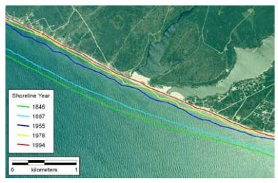
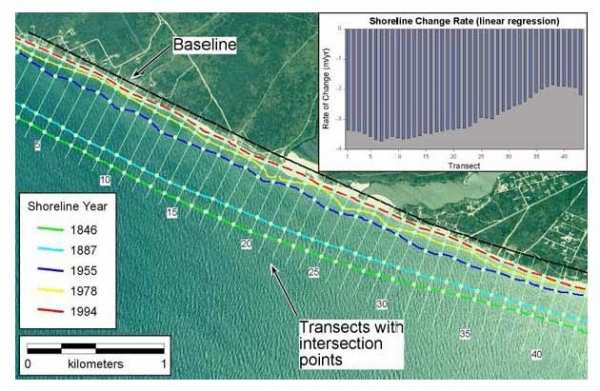
The Digital Shoreline Analysis System (DSAS) version 3.2 is a software extension to ESRI ArcGIS© v.9+ that enables a user to calculate shoreline rate-of-change statistics from multiple historic shoreline positions. A user-friendly interface of simple buttons and menus guides the user through the major steps of shoreline change analysis. Components of the extension and user-guide include: 1) instruction on the proper way to define a reference baseline for measurements; 2) automated and manual generation of measurement transects with user-specified parameters; and 3) output of calculated rates of shoreline change and other statistical information. DSAS computes shoreline rate-of-change using four different methods: 1) simple linear regression; 2) weighted least squares regression; 3) endpoint rate; and 4) jackknife iterative regression techniques. The standard error, correlation coefficient, and confidence interval are also computed for the simple and weighted least squares methods. All output data are written to the attribute table associated with each transect. DSAS is intended to facilitate the shoreline change calculation process, providing both rate-of-change information and the statistical data necessary to establish the reliability of the calculated results. The DSAS is also suitable for any generic "positional change over time" application, such as assessing rates of change of glacier limits in sequential aerial photos, river edge boundaries, land cover changes, etc.
A public bulletin board for DSAS support is available at http://woodshole.er.usgs.gov/cgi-bin/discus/show.cgi?2/2 to report bugs, as well as to exchange tips and techniques with the authors and other DSAS users.
DSAS transects created in the previous DSAS v.2x (for ArcView 3.x) can now be imported for use in the current version of DSAS.� Click here to download the stand-alone utility.�
A version of DSAS for ArcView 3.x is available. Click here for a link to that page.
|
|