1984 MMS SUMMARY REPORT
The report presented below (Thomas, 1985) was previously submitted as an administrative report by the State of Connecticut in fulfillment of their agreement with the Minerals Management Service. It is included here as part of this report solely to broaden the perspective of those individuals interested in the geologic framework and the Late Quaternary depositional history of Long Island Sound.
Final Summary Report for a study of
THE GEOLOGIC FRAMEWORK OF SOUTHERN NEW ENGLAND:
VIBRACORING OF LONG ISLAND
submitted to
Minerals Management Service
Department of Interior
in fulfillment of reporting requirements
Subagreement MMS/AASG
For the Period
January 1, 1984 - September 28, 1985
by
Dr. Hugo F. Thomas
Director and State Geologist
State of Connecticut
Department of Environmental Protection
Natural Resources Center
165 Capitol Avenue, Room 553
Hartford, CT 06106
1984
INTRODUCTION
During the first year (FY '83) of the Minerals Management Service (MMS)/Association of American State Geologists (AASG) cooperative program, the State of Connecticut (and several of the other New England states) received valuable and timely MMS support for ongoing geologic investigations of the inner continental shelf of southern New England. In our case, this support proved to be extremely important because it was used to fill a critical void in our offshore physical data collection capability.
Since 1981 the State of Connecticut has been cooperating with the United States Geological Survey (USGS) in a westward continuation of their marine "geologic framework" studies that developed basic geologic information along the Massachusetts coast
(Massachusetts-Co-op.) and in Rhode Island Sound. Although the Connecticut/USGS cooperative effort has been very successful in carrying out the first systematic high-resolution, seismic-reflection survey of the inner shelf in the vicinity of Long Island and Block Island Sounds, budgetary constraints had limited our work to seismic data collection with no provision for the coring necessary to verify the geophysics. This shortcoming was of particular concern to us because cores had not been obtained in Rhode Island Sound and the best available control was from
Massachusetts-Co-op. core data that were derived seventy miles east of, and across the Orient Point-Charlestown
moraine from our study area.
 The costs of mounting and carrying out a successful offshore coring effort are prohibitive for most individual states and prior to the availability of MMS support our prospects for obtaining cores in Long Island Sound were not good. We sincerely believe that by providing a timely opportunity for Connecticut, Rhode Island, Massachusetts, and New Hampshire to pool their resources and obtain important core data in their respective marine jurisdictions, the Minerals Management Service has made a major contribution to our understanding of the basic geologic framework of the inner shelf of southern New England. The costs of mounting and carrying out a successful offshore coring effort are prohibitive for most individual states and prior to the availability of MMS support our prospects for obtaining cores in Long Island Sound were not good. We sincerely believe that by providing a timely opportunity for Connecticut, Rhode Island, Massachusetts, and New Hampshire to pool their resources and obtain important core data in their respective marine jurisdictions, the Minerals Management Service has made a major contribution to our understanding of the basic geologic framework of the inner shelf of southern New England.
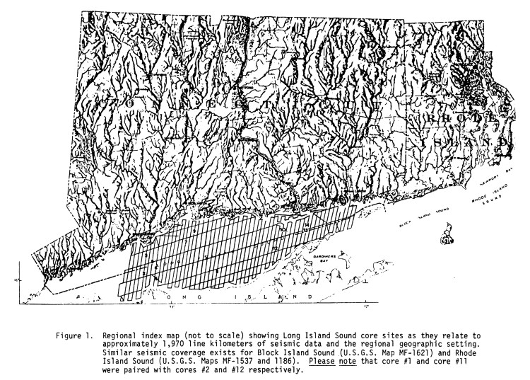
This report outlines Connecticut's part of the four state coring effort and is submitted to MMS as the final deliverable of our first year (FY '83) project. Connecticut applied its entire FY '83 distribution ($24,535) to the coring effort and thirteen cores were successfully obtained at selected sites in Long Island Sound
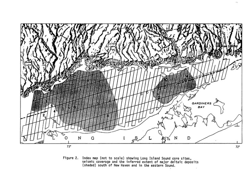
(Figure 1). Cores obtained using FY '83 funds have been instrumental in confirming the presence of extensive lacustrine deposits under Long Island Sound, and we are confident that detailed analysis of the Long Island Sound cores will provide us with basic information concerning large deltalc deposits
(Figure 2) that have been recognized south of the Connecticut and Quinnipiac Rivers. The results discussed herein are preliminary but Connecticut will use resources that are not part of the MMS/AASG cooperative (State funds, etc.) to carry out follow-up, detailed investigations of the cores. We intend to publish the results of these investigations and we will provide MMS with copies of all core-related materials that we produce.
OVERALL CRUISE REPORT AND FOUR-STATE PROJECT SUMMARY
Vessel: R/V Atlantic Twin (Alpine Ocean Seismic Survey, Inc.)
Cruise Number: AT-84-1
Parent Project: MMS/Coastal States Co-op. (14-12-0001-30115)
Funding Agency: Minerals Management Service (WS)
Funding Amount: $24,535 (Connecticut portion)
Contract Period: January 1, 1984 - September 28, 1985
Area of Operations: Long Island Sound, Block Island Sound, Narragansett Bay, Rhode Island Sound, Massachusetts Bay, New Hampshire Coast.
Cruise Dates: 26 Sept. 84 - 19 Oct. 84
Details:
26 Sept. - 29 Sept.
29 Sept. Engine failure - resume cruise Oct. 5, 1984
5 Oct. - Oct. 6 Long Island Sound
7 Oct. Block Island Sound
8 Oct. Narragansett Bay/Block Island Sound
9 Oct. Rhode Island Sound/Transit to Woods Hole, MA. (offload cores)
10 Oct. Transit to Portsmouth, New Hampshire
11 Oct. - 12 Oct. New Hampshire Coast
13 Oct. - 18 Oct. Massachusetts Bay
19 Oct. Transit to Woods Hole, MA (offload cores)
End Cruise
Chief Scientist: Ralph S. Lewis - Connecticut Geological and Natural History Survey
Cruise Data Contact: Ralph S. Lewis (203) 446-1020 Ext. 213 or 214
Scientific Party:
Ralph Lewis (Conn.) 26 Sept. - 12 Oct.
Nancy Friedrich (R.I.) 26 Sept. - 8 Oct.
Francis Birch (N.H.) 11 Oct. - 12 Oct.
Gerald Edwards (Mass/USGS) 10 Oct. - 19 Oct.
Ship's Captain: Wally Van Horn (Alpine)
Purpose of Cruise: To obtain vibracores at selected targets (46) in the coastal waters of Connecticut, Rhode Island, Massachusetts, and New Hampshire.
Navigation: Core sites were located using LORAN-C positioning (a complete record of pertinent navigation data is on file with the cores at Woods Hole).
Seismic System: (Supplied by Alpine with funding from
USGS)
Sparker: Innerspace Technology (Model 201) 20 joules
Recorder: Grifft (Model 4000T)
Hydrophone: Innerspace Technology (25 element)
Vibracorer: Alpine 30 foot system
Summary:
The states of Connecticut, Rhode Island, Massachusetts and New Hampshire pooled their resources to hire Alpine
Ocean/Seismic Survey, Inc., to obtain vibracores at forty six sites of scientific interest. Each state contributed all or a portion of their F.Y. 1983 MMS monies to the pool and each received a number of cores commensurate with their contribution (CT.- 14,
Rl 6, MA- 14, NH - 12). The four states were fortunate enough to be able to work with the New England Governor's Conference, Inc., which acted as the contracting agent for this project. Although equipment/weather problems caused some delays the scientific objectives of each participant were met (44 cores were obtained) and the project was a success.
The pooling of individual state resources proved to be a very effective way to obtain a platform and product that the states singly could not have afforded. Each state determined its level of involvement, and the joint effort was a turn-key type contract that provided a mechanism for obtaining cores. Each of the participating states still has an individual responsibility to live up to its subagreement with MMS (in terms of deliverables, etc.). The cores are being curated through the good offices of the United States Geological Survey, Woods Hole, MA
(USGS, Office of Marine Geology also provided funding to operate seismic reflection equipment during the cruise). For further information see attachments and/or contact Ralph Lewis, University of Connecticut, Avery Point, Groton, Ct. 06340
METHODS AND OBJECTIVES (Long Island Sound)
Fourteen primary and fourteen backup core sites were selected prior to the vibracoring cruise. This selection was based on an analysis of 2,670 line kilometers of high-resolution, seismic-reflection data that was collected in Long Island Sound and Block Island Sound between 1981 and 1984. The suite of selected targets
(Figure 1) afforded an opportunity to penetrate most of the significant regional features that could be recognized on the seismic records. Our objective was to sample the major stratigraphic units of the basin so that we could confirm or modify our inferred seismic
stratigraphy.
Once the potential targets had been identified they were reviewed with the contractor (Alpine Ocean Seismic Survey, Inc.) prior to the cruise. The contractor supplied a small seismic-reflection system (sparker) that was used to verify the targets In the field. This was accomplished by running along each original seismic line until the target was recognized. The target coordinates were marked using the Atlantic Twin's LORAN system and we anchored up on those coordinates. Average survey time was about twelve minutes per site. This method worked well and we were able to identify all of our targets prior to coring.
RESULTS
Cores were obtained at thirteen of the fourteen sites. Strong
currents precluded successful coring at one location (Site 14, Figure
2) and caused anchoring problems at another (Site 9, Figure
2). Except for these problems, our objectives were met as follows: Two locations were chosen so as to penetrate the inferred Pleistocene-Holocene contact. Cores LISAT 2 and LISAT 3
(Figure 2) achieved this goal (see data sheets and seismic lines in appendix). Please note that Core LISAT
1 was a test core. Core LISAT 2 penetrated about 200 cm of fine sand and silt that we believe to be the Holocene section on the records. This material grades downward to a deposit of better sorted sand. The sand shows up as a "confused" layer on the seismic records and may be reworked. At 343 cm the bottom
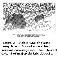 of the sand rests unconformably on silt and clay. The seismic records show that these fine sediments are up to 130 meters thick in the vicinity of Core 2, and we have inferred that they represent Pleistocene lake deposits. Core LISAT 3 penetrated about 206 cm of fine sand, silt and clay that we infer to be the Holocene section. This sediment rests unconformably on an extensive
(Figure 2), thick, sandy deposit that is probably outwash. of the sand rests unconformably on silt and clay. The seismic records show that these fine sediments are up to 130 meters thick in the vicinity of Core 2, and we have inferred that they represent Pleistocene lake deposits. Core LISAT 3 penetrated about 206 cm of fine sand, silt and clay that we infer to be the Holocene section. This sediment rests unconformably on an extensive
(Figure 2), thick, sandy deposit that is probably outwash.
Locations 4 and 5 (Figure
2) were chosen to sample outliers that sit north of the main body of coastal-plain sediments. These features are likely to be remnants of coastal-plain strata that are capped by morainal material. Core LISAT 4 penetrated 130 cm of poorly sorted material that is probably moraine. It is certainly hard to core. Core LISAT 5 penetrated 195 cm of alternating sand, silt and clay. This material rests on dry, compact silty sand that we infer to be coastal-plain strata. We hope to determine the age of the silty sand.
Location 6 (Figure
2) was chosen to provide a good example of glacial lake-clay from Long Island Sound. Core LISAT 6 penetrated 145 cm of reworked Holocene material and 638 cm of varved, reddish-brown clay. This core established the existence of an extensive lake-clay deposit under Long Island Sound. The reddish color of the clay indicates that its source was probably the Connecticut Valley. The distinctive seismic signature of the clay will be an important tool in further work. Owing to its significance, we intend to carry out a detailed analysis of this core.
Locations 7 and 8 (Figure
2) were picked for two reasons. The first was to sample a thin deposit that appears to be related to the last marine encroachment into Long Island Sound. At Locations 7 and 8 this thin deposit overlies material that we believe to be part of the New Haven outwash deposit
(Figure 2) and we wanted samples of this deltaic material also. The upper 200 cm of Core LISAT 7 probably represents the Holocene section. The more complex sandy section between 200 and 265 cm may be estuarine sediment that was deposited during the last marine transgression. The lower 100 cm of this core probably penetrated the top of the outwash deposit. Core LISAT 8 penetrated about 300 cm of Holocene - silty clay. The zones of sand between 300 and 376 cm way be the thin estuarine deposit. The bottom 234 cm of layered, fine to coarse sand 1s probably the top of the outwash.
Location 9 (Figure
2) was chosen because it afforded an opportunity to penetrate a small beach-like feature that rests on the outwash. Unfortunately, we had problems with anchoring at this site and we may have missed the feature. Core LISAT 9 penetrated 570 cm of Holocene - silt and clay. The lower 170 cm of this material (400-570 cm) has sandy zones and may be equivalent to the estuarine deposit that was penetrated at sites 7 and 8. The bottom 115 cm of Core LISAT 9 penetrated dark-brown, fine sand that looks homogeneous. We are not sure if this is part of the target feature or just outwash. We hope to look into this question further.
Locations 10, 11 and 12 (Figure
2) were chosen to give us a shot at penetrating a very important contact that appears on records from throughout the eastern Sound. This flat surface cuts the lake-clays and is overlain by complex sediments. We have inferred that the surface was cut during the last marine transgression. If this is true, it should be a contact of marine and freshwater deposits. We cored it in hopes of being able to test this idea. Core LISAT 10 penetrated 171 cm of medium to coarse sand and gravel. We think this is marine sediment. We will try to date the wood from the bottom of this material. The sharp contact at 171 cm should be the wave-cut marine unconformity and the silty clay below it is probably a freshwater lake deposit. Cores LISAT 11 and 12 were obtained at the same anchor point. Core LISAT 11 penetrated only marine sediment and did not reach the contact. Core LISAT 12 penetrated about 530 cm of marine sediment The contact with the clays is at about 560 cm. We hope to use these cores to determine the nature and age of the marine transgression, and if possible to look at the eastern Long Island Sound lake-clays.
Location 13 (Figure
2) was chosen to penetrate a complex portion of the eastern deltaic deposit that overlies the lake-clays. This deposit appears to be associated with the Connecticut River and it is post-transgressive. Core LISAT 3 penetrated 370 cm of medium to coarse sand, gravel, pebbles, and rocks. Red sandstone may be present in this material. If so, the coarse deposit may be related to the post-glacial history of the Connecticut River Valley. The coarse material lies unconformably on varved lake-Clay. The clay extends to the bottom of the core. This core could be important in helping us unravel the history of the eastern Sound. We hope to do a lot more with it.
Location 14 (Figure
2) was also chosen to penetrate the eastern deltaic material. Unfortunately, strong currents precluded coring at this location (two attempts were made).
PRELIMINARY OUTLINE OF GEOLOGIC FRAMEWORK
From Florida to New York City the "wedge" of coastal-plain sediments that makes up the continental shelf also extends many miles inland, and coastal-plain strata pinch out against the eastern flank of the Appalachian Mountains. From New York City eastward to the Scotian shelf this is not the case. Waterbodies such as Long Island, Block Island and Rhode Island Sounds and the Gulf of Maine lie over a string of lowland basins that form the inner margin of a dissected coastal-plain "wedge". The seaward flank of this inner lowland is marked by 4 north-facing cuesta scarp that is cut in coastal-plain strata. The position of this cuesta scarp often coincides
with or is close to the maximum extent of the late Wisconsinan ice sheet.
Long Island Sound occupies the western-most basin of the inner lowland. The Long Island Sound basin 1s bounded seaward by a highly dissected, north-facing escarpment of Cretaceaous coastal-plain strata, and is floored by crystalline rocks of
pre-Mesozoic age. The south-dipping bedrock surface under Long Island Sound is a seaward extension of the bedrock that underlies coastal Connecticut* Submerged extensions of the Connecticut and Thames River bedrock valleys dip under the coastal-plain cuesta, and the general morphology and slope of the submerged bedrock surface is very similar to that of the glacially modified bedrock on land.
From about the middle of Long Island Sound southward, the bedrock is overlain by coastal-plain strata. The north-facing cuesta scarp rises an average of 90-100 m above the bedrock/coastal-plain contact, but the cuesta is very irregular. Several large valleys, up to 140 m deep, incise the coastal-plain strata. The morphology and distribution of these valleys suggest that they are glacially modified fluvial features. Opportunities for extensive fluvial erosion of the coastal-plain strata occurred during major sea level lowerings in the Oligocene, Late Pliocene and Early Pleistocene. If a reasonably well developed, fluvially-cut inner lowland existed prior to the later glaciations, its position may have influenced the pattern of the Wisconsinan ice advances.
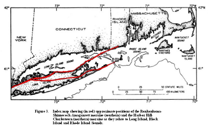
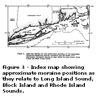 Glacial deposits overlie the bedrock and the coastal-plain remnant throughout the lowland. Two major moraine lines cap the cuesta
(Figure 3). The terminal position of the late Wisconsinan ice lobes is marked by the Ronkonkoma, Shinnecock and Amagansett moraine line. After reaching this maximum, retreating ice formed several series of sub-parallel moraines. The roost prominent of these (Harbor Hill-Charlestown) lies on or near the cuesta scarp and runs along the north shore of Long Island, across Plum Island, the entrance to Long Island Sound, Fishers Island, and the coast of Rhode Island. Submerged, westward extensions of the Clumps and Old Saybrook moraines have been recognized in eastern Long Island Sound, and deposits of till .that are often over 10-m thick are scattered throughout the lowland. Glacial deposits overlie the bedrock and the coastal-plain remnant throughout the lowland. Two major moraine lines cap the cuesta
(Figure 3). The terminal position of the late Wisconsinan ice lobes is marked by the Ronkonkoma, Shinnecock and Amagansett moraine line. After reaching this maximum, retreating ice formed several series of sub-parallel moraines. The roost prominent of these (Harbor Hill-Charlestown) lies on or near the cuesta scarp and runs along the north shore of Long Island, across Plum Island, the entrance to Long Island Sound, Fishers Island, and the coast of Rhode Island. Submerged, westward extensions of the Clumps and Old Saybrook moraines have been recognized in eastern Long Island Sound, and deposits of till .that are often over 10-m thick are scattered throughout the lowland.
The terminal moraine and probably the Harbor Hill-Charlestown moraine to its north dammed meltwater as the ice retreated from the lowland. These dams persisted long enough for the entire area to be choaked by
varved, lake-clay deposits. These lake clays are thickest (up to 150 m) in the valleys that incise the coastal-plain strata but they are found throughout the lowland (LISAT cores 2, 6, 10, 12 and 13 penetrated the lacustrine deposits). To the south, the lacustrine deposits pinch out against coastal-plain strata and/or moraine. To the north they pinch out against bedrock or older glacial material. Locally the c1ays extend into estuaries along the Connecticut coast (e.g. New Haven Harbor). Topset/foreset contacts in lake deltas that are preserved along the Connecticut coast indicate that the maximum extent of the lake was similar to the present area of Long Island Sound.
Several features that are relevant to the later history of the lake lie in and around the Long Island Sound basin. A ridge composed of bedrock and coastal-plain strata extends across the basin south of Branford, CT. East of this high, the lake clays are incised by stream valleys which are in turn truncated by a widespread, flat unconformity (LISAT cores 10, 12 and 13 penetrated this surface). This evidence suggests that the lake clays were subaerial ly exposed before wave action associated with the last marine transgression beveled the lake-clay surface. West of the Branford high and as far west as Bridgeport, CT, evidence of subaerial exposure of the lake clays has not been found. In this area, the lake clays are overlain by an extensive outwash-deposit that appears to have spread over a fairly well preserved lakebed. East of New Haven, the outwash- is commonly 20-45 m thick, and it extends southward to the north shore of Long Island (LISAT cores 3, 7, 8 and 9 penetrated the outwash).
A potential outlet for lake waters exists at the head of Block Channel (between Montauk Point and Block Island) where the terminal moraine is notched to approximately 75 m below sea level. This outlet could have provided a path for eastward drainage of the Long Island Sound lake. As the lake lowered, the Branford high may have emerged and prevented or delayed complete draining of the central part of the lake.
South of the Connecticut River, the remains of a fairly extensive, complex deposit overlies the marine unconformity that bevels the lake clays. This deposit post-dates the last transgression and is therefore marine. It is probably made up of material that was washed down the Connecticut River after the last ice had retreated (LISAT cores 10, 12 and 13 penetrated
this deposit).
A cover of Holocene mud blankets most of the basin. East of Clinton, CT, strong currents have cut deeply into the glacial deposits, and locally the coastal-plain strata. Much of the bottom topography of the eastern Sound is a result of this continuing modern erosion.
CONCLUSION
We have just begun the long process of relating the core data to the seismic records but the importance of the cores is already apparent. We are confident that the cores will provide valuable information concerning several of the major features that are mentioned in this report. This in itself will be a major contribution to our understanding of the southern New England inner shelf.
The fact that we were quite successful in our attempts to core rather specific targets leads us to believe that our future efforts in the non-energy resources area (year two and three joint proposals with the University of Rhode Island) will also be successful. He would like to thank the Minerals Management Service for the support that allowed us to initiate this
program of investigations and we hope that the information that we are developing will be of value to all concerned.
|