|
    
Block Island Sound
Eastern Long Island Sound
East-Central Long Island Sound
West-Central Long Island Sound
Western Long Island Sound
Fishers Island Sound and Northeastern Long Island
Sound        
|
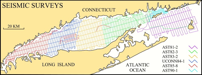
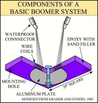
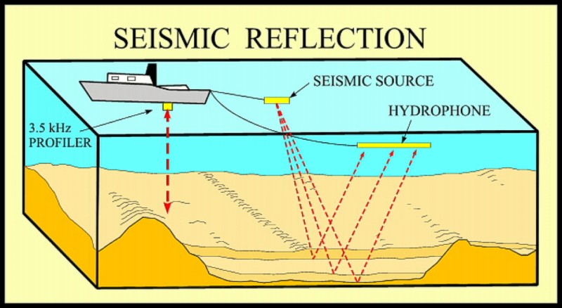
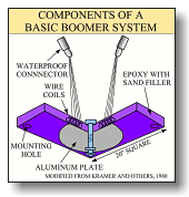 High-resolution seismic-reflection profiles from six cruises, which together provide a regional coverage for most of Long Island and Block Island Sounds, are presented in this report. Most of these profiles were obtained using EG&G Uniboom and Geoacoustics Geopulse boomer systems. These systems, which have a broad-band sound source that operates in the 300Hz - 3kHz range, were powered by a 300-J power supply. As electricity from the power supply passes through wire coils, spring loaded plates in the boomer transducer are electrically charged causing the aluminum plates to repel, thus generating an acoustic pulse (see boomer insert; Kramer and others, 1980; U.S. Geological Survey, 2001). This system is commonly mounted on a
floatation sled and towed behind the boat. High-resolution seismic-reflection profiles from six cruises, which together provide a regional coverage for most of Long Island and Block Island Sounds, are presented in this report. Most of these profiles were obtained using EG&G Uniboom and Geoacoustics Geopulse boomer systems. These systems, which have a broad-band sound source that operates in the 300Hz - 3kHz range, were powered by a 300-J power supply. As electricity from the power supply passes through wire coils, spring loaded plates in the boomer transducer are electrically charged causing the aluminum plates to repel, thus generating an acoustic pulse (see boomer insert; Kramer and others, 1980; U.S. Geological Survey, 2001). This system is commonly mounted on a
floatation sled and towed behind the boat.
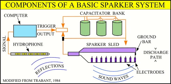
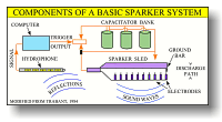 A 300-J pressurized minisparker was used instead of the boomer systems for one line collected across Block Island Sound during the 1982
ASTERIAS cruise. The sparker is a relatively higher powered sound source, dependant on an electrical arc which momentarily vaporizes water between positive and negative leads (see insert; Trabant 1984; U.S. Geological Survey, 2001). The collapsing bubbles produce a broad band (50Hz - 4 kHz)
omni directional pulse. Hydrophone arrays towed nearby receive the return signals. Reflected seismic data from both systems were variously acquired with
Innerspace, EG&G, and Benthos hydrophone streamers.
A 300-J pressurized minisparker was used instead of the boomer systems for one line collected across Block Island Sound during the 1982
ASTERIAS cruise. The sparker is a relatively higher powered sound source, dependant on an electrical arc which momentarily vaporizes water between positive and negative leads (see insert; Trabant 1984; U.S. Geological Survey, 2001). The collapsing bubbles produce a broad band (50Hz - 4 kHz)
omni directional pulse. Hydrophone arrays towed nearby receive the return signals. Reflected seismic data from both systems were variously acquired with
Innerspace, EG&G, and Benthos hydrophone streamers.
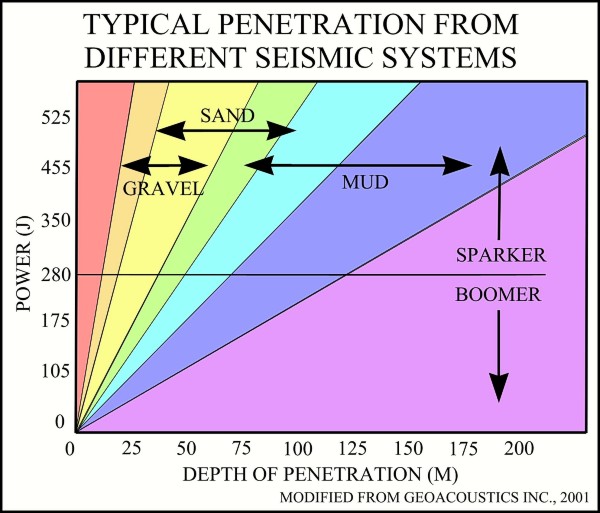
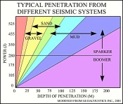 Minisparkers typically yield better penetration, but poorer resolution than boomer systems. Resolution of boomer systems typically ranges from 0.5 to 2 m; penetration 100 m. Acoustic pulses from minisparkers can penetrate a few hundred meters into the subsurface (see insert; Geoacoustics Inc., 2001; U.S. Geological Survey, 2001). Minisparkers typically yield better penetration, but poorer resolution than boomer systems. Resolution of boomer systems typically ranges from 0.5 to 2 m; penetration 100 m. Acoustic pulses from minisparkers can penetrate a few hundred meters into the subsurface (see insert; Geoacoustics Inc., 2001; U.S. Geological Survey, 2001).
 Most of the data collection was performed aboard the Woods Hole Oceanographic Institution
Research Vessel ASTERIAS; the 1984 cruise was conducted aboard the
University of Connecticut Research Vessel
UCONN. The seismic signals were bandpass-filtered between 400 and 4,000 Hz and were recorded on 19.75 inch-wide paper using EPC 4100 and 4603
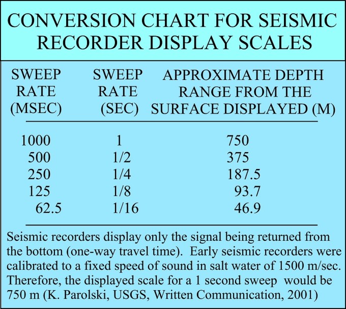
programmable graphic recorders and, typically, a 0.25-second sweep
rate. Tracklines were run at an average ship speed of five knots. Ship position was determined using a Northstar 6000 Loran C for navigation; fixes were recorded every five minutes and at course changes. Generally, absolute accuracy for the navigation varies spatially, but averages approximately 185 m (D. Olmsted, Woods Hole Oceanographic Institution, oral communication). Individuals interested in the equipment used on a specific cruise and its configuration should check the cruise reports for more detail. Most of the data collection was performed aboard the Woods Hole Oceanographic Institution
Research Vessel ASTERIAS; the 1984 cruise was conducted aboard the
University of Connecticut Research Vessel
UCONN. The seismic signals were bandpass-filtered between 400 and 4,000 Hz and were recorded on 19.75 inch-wide paper using EPC 4100 and 4603
programmable graphic recorders and, typically, a 0.25-second sweep
rate. Tracklines were run at an average ship speed of five knots. Ship position was determined using a Northstar 6000 Loran C for navigation; fixes were recorded every five minutes and at course changes. Generally, absolute accuracy for the navigation varies spatially, but averages approximately 185 m (D. Olmsted, Woods Hole Oceanographic Institution, oral communication). Individuals interested in the equipment used on a specific cruise and its configuration should check the cruise reports for more detail.
 |
|
|
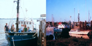
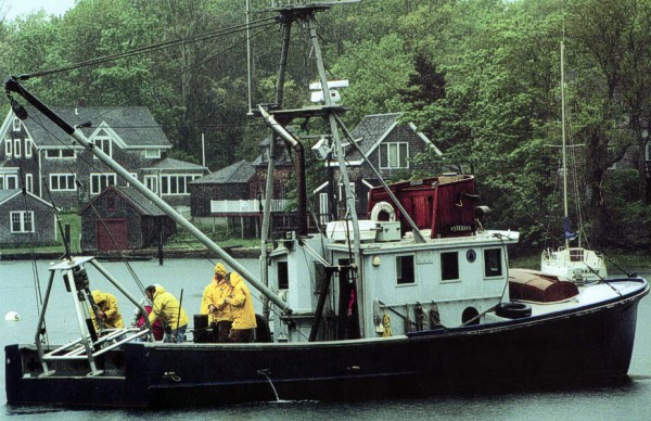
Crew aboard R/V ASTERIAS deploying a mooring.
|
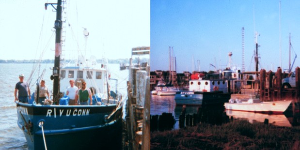
Two views of R/V UCONN at dock.
|
The seismic profiles on this DVD are supplied as images in both TIF and GIF formats. The TIF images (Group IV compression method) are higher resolution (300 dpi) and
are provided as archives of the original paper seismic records and for plotting at full scale (19.75 inches wide). The TIF images were generated
by the New England Archive Center with a large-format Vidar Flash scanner using Imagation software. The GIF images, which were generated from the TIF images, are lower resolution, compressed, faster loading and provided as previews for rapid viewing.
The TIF images can be accessed by cruise through data tables or downloaded directly from cruise subdirectories of the
data/seismics folder located at the top level of this
DVD. The GIF images can be accessed by cruise through data tables and interactive
maps.
Trackline navigation files are provided by cruise in ASCII, Microsoft Excel, and HTML formats through the links below. The ASCII files are comma
delimited. All formats include fields for cruise id, date, time, line number, and latitude and longitude in decimal degrees. Alternately, the navigation files may be downloaded directly from cruise subdirectories of the
data/nav folder at the top level of this report.
The file naming structure for the seismic-reflection and navigation files is based on a cruise identifier, the line number, and a character indicating the section of that line (in case a line had to be broken into several sections). For example, a82_319b.tif signifies the
RV
ASTERIAS as the vessel, 1982 as the year, 3 as the leg, 19 as the line number, and b as the section. The suffix indicates file format.
|

