USGS Coastal and Marine Hazards and Resources Program
![]() Title | Introduction
| Methods | Reconnaissance Bathy |
Interpolated Bathy | Catalog
| Acknowlegments | References
| Figures
| Contacts
Title | Introduction
| Methods | Reconnaissance Bathy |
Interpolated Bathy | Catalog
| Acknowlegments | References
| Figures
| Contacts
 |
||
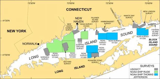
Figure 1. Map showing locations of NOAA surveys H11043, H11044, and H11045 (green polygons). Sidescan sonar imagery from these surveys was interpreted by Poppe and others (2004a), McMullen and others (2005), and Beaulieu and others (2005) respectively. Also shown are the sites of other interpreted multibeam bathymetric surveys (blue polygons) and sidescan sonar surveys (gray polygons) in Long Island Sound. Multibeam surveys: H11250 -- (Poppe and others, 2004b); H11255 -- (Poppe and others, 2005). Sidescan surveys: Norwalk -- Twichell and others (1997); Milford -- Twichell and others (1998); New Haven Harbor and New Haven Dumping Grounds -- Poppe and others (2001); Roanoke Point -- Poppe and others (1999a); Falkner Island -- Poppe and others (1999b); Hammonasset -- Poppe and others (1997); Niantic Bay -- Poppe and others (1998a); New London -- Zajac and others (2000, 2003); Fishers Island Sound -- Poppe and others (1998b). | ||
