|
Bathymetric data from multibeam reconnaissance surveys have been interpolated and regridded into complete-coverage data sets and imagery of the sea floor. Within the context of sea-floor mapping, the word “reconnaissance” typically refers to surveys with ship-track spacing too great to acquire 100% coverage of the sea floor at the specified resolution. This approach, which resulted in original bathymetric data sets that had stripes of no data between the multibeam lines, was acceptable for nautical charting purposes because 100% coverage was achieved with concurrently collected sidescan sonar (Poppe and others, 2004; McMullen and others, 2005; Beaulieu and others, 2005).
Sidescan sonar lines are typically spaced 150 m apart; height of the towed sidescan fish above the sea floor is controlled by adjusting cable length to allow data collection 100 m to each side. Because this results in a 50-m data overlap, the ship can maneuver around lobster pots and other obstructions and still efficiently survey 100% of the seabed. Conversely, the Reson multibeam system is hull mounted. Swath width can not be increased without producing an unacceptably low data density and, therefore, line spacing would have to be decreased to acquire 100% multibeam bathymetric coverage, greatly increasing the time necessary to complete surveys.
For purposes of comparison with the interpolated data, views of the original multibeam reconnaissance bathymetry are provided for surveys H11043, H11044, and H11045 in figure 4, figure 5, and figure 6, respectively. Areas of no data within the original surveys constituted approximately 30% of H11043, 10% of H11044, and 45% of H11045.
|
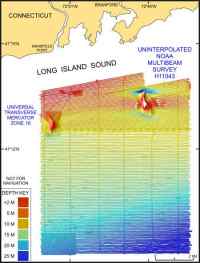 |
Figure 4. Image shows the original uninterpolated reconnaissance multibeam bathymetry from NOAA survey H11043 in north-central Long Island Sound off Branford, Connecticut. Click on figure for larger image.
|
|
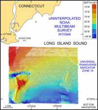 |
Figure 5. Image shows the original uninterpolated reconnaissance multibeam bathymetry from NOAA survey H11044 in north-central Long Island Sound off Milford, Connecticut.
|
|
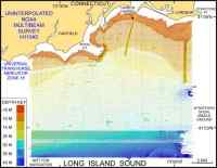 |
| Figure 6. Image shows the original uninterpolated reconnaissance multibeam bathymetry from NOAA survey H11045 in north-central Long Island Sound off Bridgeport, Connecticut. |
|
|
