Woods Hole Science Center
Surficial Geology in Central Narragansett Bay, Rhode Island: Interpretations of Sidescan Sonar and Multibeam Bathymetry
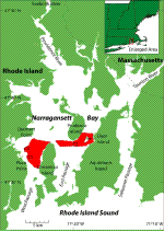
Narragansett Bay, located in eastern Rhode Island and southern Massachusetts, is a north-south trending estuary that is about 30 km long and 15 km wide (fig. 1). Three large islands, Conanicut, Prudence, and Aquidneck, separate the Bay into West Passage, East Passage, and Sakonnet Passage. In the northeast, the Taunton River enters the Bay; in the northwest, the Providence and Seekonk Rivers enter the Bay. The stratigraphy of Narragansett Bay is composed of glacial drift and post glacial sediments overlying bedrock. Pre-Pennsylvanian igneous and metamorphic rocks and a few late- or post-Pennsylvanian intrusive granites in the southwest surround the Bay (Quinn, 1953; Quinn and others, 1957; McMaster, 1960). Pleistocene glacial drift overlies bedrock in Narragansett Bay (Shaler and others, 1899; McMaster, 1960). Overlying the glacial drift are up to 15 m of Holocene estuarine deposits (Upson and Spencer, 1964; McMaster, 1984). A southward flowing drainage system in the area was established in Narragansett Bay during the Tertiary (McMaster, 1984). Pleistocene glaciation and Holocene deposition altered these valleys into deep channels filled with Quaternary sediments, reaching up to 134-m thick near the mouth and 40-m thick in the upper Bay (Collins, 1978; McMaster, 1984). Around 15,500 yr BP, proglacial Lake Narragansett formed in the Bay and drained within 500 years, leaving a post-glacial river running along its axis (U.S. Army Corps of Engineers, 1957; Upson and Spencer, 1964; Pickart, 1987; Peck and McMaster 1991; Uchupi and others, 2001). Around 9000 yr BP, sea level rose, flooded the area, and introduced estuarine conditions and sediment deposition that continue today (McMaster, 1984). In general, two layers of currents exist in Narragansett Bay, a tidal current flows northward along the bottom of the estuary and a non-tidal current flows southward at the surface (Hicks, 1959; McMaster, 1960). A study near the Taunton River found a stratified pattern of flow strongly influenced by topography, with little influence from wind (Spaulding and White, 1990). However, circulation over the entire water column in West Passage is strongly influenced by the wind, which can cause current direction to change 180 degrees in a day (Weisberg and Sturges, 1976). |