Woods Hole Science Center
Surficial Geology in Central Narragansett Bay, Rhode Island: Interpretations of Sidescan Sonar and Multibeam Bathymetry
|
|
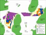
Interpretations of the surficial sediment distribution are based on sediment samples, sidescan sonar imagery, and multibeam bathymetry. McMaster (1960) obtained and analyzed 46 samples of surficial sediment from within our study area (fig. 9). The northern parts of the West Passage study area are mostly clayey or sandy silts. Two patches of sand silt clay exist south of Quonset Point. There are two areas of silty sand in the West Passage study area, one in the center and another along the trough. Most of the nearshore borders of the study area are sandy. Two patches of gravelly sediments are located between Plum Point and Conanicut Island. The East Passage study area has silts throughout much of the west and in southern parts of the trough. A patch of sand silt clay exists south of Prudence Island. Silty sand covers much of the area between Dyer and Aquidneck Islands as well as an area southwest of Dyer Island. Sand is present along the eastern coast of Prudence Island. Gravel and gravelly sediments surround Dyer Island and continue along the western coast of Aquidneck Island. Sediment entering Narragansett Bay from rivers and streams is composed of fine and very fine sands, silts and clays; however, this quantity is small due to impoundment of sediment with the construction of dams on the rivers (McMaster, 1960). Wind-driven waves, storm erosion, and tidal currents rework the sea floor in Rhode Island sound and the glacial sediments along the shoreline, contributing to a larger source of transported sediment in the Bay (Stetson, 1938; McMaster, 1960). Coarser grained sediment is abundant in shallow depths and constricted areas where the sediment is winnowed by waves and currents. Fine grains are transported from these high-energy environments and deposited in low-energy environments where bathymetry is smooth and broad and water depths are moderate to deep. Fine sands and sand silt clay are present in transitional areas between high- and low-energy environments and where bathymetry is variable. |