Woods Hole Science Center
Enhanced Sidescan-Sonar Imagery, North-Central Long Island Sound
|
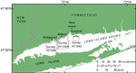
The U.S. Geological Survey (USGS) is working cooperatively with the Connecticut Department of Environmental Protection (CT-DEP) and the National Oceanic and Atmospheric Administration (NOAA) to map the sea-floor geology within Long Island Sound (LIS). As part of this cooperative effort, sidescan-sonar imagery and multibeam bathymetric data collected by NOAA during hydrographic surveys are used to interpret surficial-sediment distribution, sedimentary environments, and other sea-floor features such as bedforms and anthropogenic structures. NOAA acquires sidescan-sonar data primarily to identify hazards to navigation and does not need internal consistency within the backscatter tones. In order to best utilize these data for geologic interpretation, artifacts within the imagery should to be minimized so that the imagery has smooth and continuous backscatter tones. Artifacts due to environmental conditions (such as sea state), variable system settings (such as gain changes), attitude variations in the flight path of the tow fish, or processing (such as a lack of across-track normalization resulting from not overriding the 16-bit shift factor in Computer Aided Resource Information System (CARIS)) create a patchwork appearance within the sidescan-sonar imagery that can obscure backscatter trends and limit our ability to interpret sea-floor geology. This report releases enhanced sidescan-sonar images from three NOAA surveys in north-central LIS (fig. 1). The enhancements minimize artifacts within the sidescan-sonar imagery and provide improved imagery that will benefit future studies within LIS. |