Map near-surface stratigraphy of continental shelf sediment.
Description
Chief Scientists: Brian Edwards, Roberto Anima. High-Resolution Seismic data (Huntec, 3dot5khz, GPS, YoNav, mudseis, bathymetry, integratednavigation, boomer) of field activity M-4-97-MB in Monterey Bay Sanctuary from 09/09/1997 to 09/17/1997
Location
Monterey Bay Sanctuary
Comments
Physical data holdings
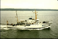
In early September, the Monterey Bay National Marine Sanctuary (MBNMS) project conducted a very successful 10-day cruise on the continental shelf between Carmel and the Golden Gate. The cruise was a very high resolution seismic-reflection cruise aboard the NOAA ship McArthur. The geophysical leg was designed to delineate the three- dimensional spatial distribution of areas of sediment erosion, deposition, bypass, and outcrops within this shelf region. We used the newly remodeled HUNTEC system to collect approximately 1400 trackline-km of very high resolution boomer data (centered in the 2-kHz to 2.5-kHz range). The system performed beautifully and provided high-quality data, at times to subbottom depths exceeding 100 m. Roberto Anima was co-chief, and Kaye Kinoshita, Rebecca Preston, and Glenn Spinelli provided support during the geophysical work. We conducted the cruise at a time when MARFAC was hard pressed with the BASIX III operation. Fred Payne, Mike Boyle, and Graham Standen (GEOFORCE tech) got to play with the HUNTEC system during the geophysical leg. I thank MARFAC and particularly Fred and Mike for their help in making the cruise successful. (Paraphrased from Brian Edwardss "CRUISE SUMMARY: MBNMS PROJECT", Western Region Coastal and Marine Geology Bulletin, November 7, 1997.)
Staff information imported from InfoBank
Bill Siles - Ship Captain
Duanne Timmons - Executive Officer
Dana Wilkes - Field Ops Officer
Brian Edwards (USGS Western Region) - Chief Scientist
Roberto Anima (USGS Western Region) - Chief Scientist
Fred Payne (USGS Western Region) - Electronics Technician
Mike Boyle (USGS Western Region) - Electronics Technician
Rebeca Preston - Geologist
Glen Spinelli - Geologist
Don Reed (San Jose State University) - Geologist
Kaye Kinoshita (USGS Western Region) - Navigator
Michelle Jacobi (NOAA) - Unspecified Investigator
Melli Lewis (NOAA) - Unspecified Investigator
Graham Standen (Geoforce) - Unspecified Investigator