High-resolution chirp seismic-reflection data collected offshore Oceanside, southern California during field activity 2017-686-FA from 2017-10-23 to 2017-10-31

Metadata also available as - [Outline] - [Parseable text] - [XML]

Frequently anticipated questions:


What does this data set describe?

Title:
High-resolution chirp seismic-reflection data collected offshore Oceanside, southern California during field activity 2017-686-FA from 2017-10-23 to 2017-10-31
Abstract:
This section of the data release contains approximately 369 line-kilometers of processed, high-resolution chirp seismic-reflection profiles that were collected aboard the R/V Snavely in 2017 on U.S. Geological Survey cruise 2017-686-FA offshore Oceanside, southern California. The along-shore and across-shore chirp profiles are oriented to assess sand and gravel resources in Federal and State waters for potential use in future beach nourishment projects along stretches of the coast where critical erosion hotspots have been identified. The chirp profiles were acquired using an Edgetech 512 Chirp sub-bottom profiling system.
Supplemental_Information:
Additional information about the field activity from which these data were derived is available online at:
https://cmgds.marine.usgs.gov/fan_info.php?fan=2017-686-FA
Any use of trade, product, or firm names is for descriptive purposes only and does not imply endorsement by the U.S. Government.
  1. How might this data set be cited?
    Sliter, Ray W., Conrad, James E., Lorenson, Thomas D., Papesh, Antoinette G., Watt, Janet T., and Warrick, Jonathan A., 2021, High-resolution chirp seismic-reflection data collected offshore Oceanside, southern California during field activity 2017-686-FA from 2017-10-23 to 2017-10-31: data release DOI:10.5066/P9UELSBU, U.S. Geological Survey, Pacific Coastal and Marine Science Center, Santa Cruz, California.

    Online Links:

    This is part of the following larger work.

    Sliter, Ray W., Conrad, James E., Lorenson, Thomas D., Papesh, Antoinette G., Watt, Janet T., and Warrick, Jonathan A., 2021, Geophysical and sampling data collected offshore Oceanside, southern California during field activity 2017-686-FA from 2017-10-23 to 2017-10-31: data release DOI:10.5066/P9UELSBU, U.S. Geological Survey, Pacific Coastal and Marine Science Center, Santa Cruz, CA.

    Online Links:

  2. What geographic area does the data set cover?
    West_Bounding_Coordinate: -117.53036
    East_Bounding_Coordinate: -117.40898
    North_Bounding_Coordinate: 33.29839
    South_Bounding_Coordinate: 33.21621
  3. What does it look like?
    https://cmgds.marine.usgs.gov/data-releases/media/2020/10.5066-P9UELSBU/1abef1575c0d4002ac7de926b66222ae/2017-686-FA_chirp_sample_map.png (PNG)
    Map showing tracklines along which chirp seismic data were collected
  4. Does the data set describe conditions during a particular time period?
    Beginning_Date: 17-Oct-2017
    Ending_Date: 31-Oct-2017
    Currentness_Reference:
    ground condition at time data were collected
  5. What is the general form of this data set?
    Geospatial_Data_Presentation_Form: seismic-reflection data in SEG-Y format
  6. How does the data set represent geographic features?
    1. How are geographic features stored in the data set?
      Indirect_Spatial_Reference:
      Horizontal X and Y locations for the seismic profile locations are provided and stored in the SEG-Y data trace headers in header bytes 81 and 85 locations with a scalar of 1.
    2. What coordinate system is used to represent geographic features?
      The map projection used is WGS 1984 UTM Zone 11N.
      Projection parameters:
      Scale_Factor_at_Central_Meridian: 0.9996
      Longitude_of_Central_Meridian: -117.0
      Latitude_of_Projection_Origin: 0.0
      False_Easting: 500000.0
      False_Northing: 0.0
      Planar coordinates are encoded using coordinate pair
      Abscissae (x-coordinates) are specified to the nearest 0.0001
      Ordinates (y-coordinates) are specified to the nearest 0.0001
      Planar coordinates are specified in Meter
      The horizontal datum used is D WGS 1984.
      The ellipsoid used is WGS 1984.
      The semi-major axis of the ellipsoid used is 6378137.0.
      The flattening of the ellipsoid used is 1/298.257223563.
      Vertical_Coordinate_System_Definition:
      Depth_System_Definition:
      Depth_Datum_Name: Local surface
      Depth_Resolution: 0.1
      Depth_Distance_Units: meters
      Depth_Encoding_Method: Attribute values
  7. How does the data set describe geographic features?
    Entity_and_Attribute_Overview:
    Navigation and seismic shots with Time Stamp in standard SEG-Y file format
    Entity_and_Attribute_Detail_Citation:
    Society of Exploration Geophysicists (SEG) Technical Standards, available for download at http://seg.org/Publications/SEG-Technical-Standards

Who produced the data set?

  1. Who are the originators of the data set? (may include formal authors, digital compilers, and editors)
    • Ray W. Sliter
    • James E. Conrad
    • Thomas D. Lorenson
    • Antoinette G. Papesh
    • Janet T. Watt
    • Jonathan A. Warrick
  2. Who also contributed to the data set?
  3. To whom should users address questions about the data?
    U.S. Geological Survey, Pacific Coastal and Marine Science Center
    Attn: PCMSC Science Data Coordinator
    2885 Mission Street
    Santa Cruz, CA

    831-460-4747 (voice)
    pcmsc_data@usgs.gov

Why was the data set created?

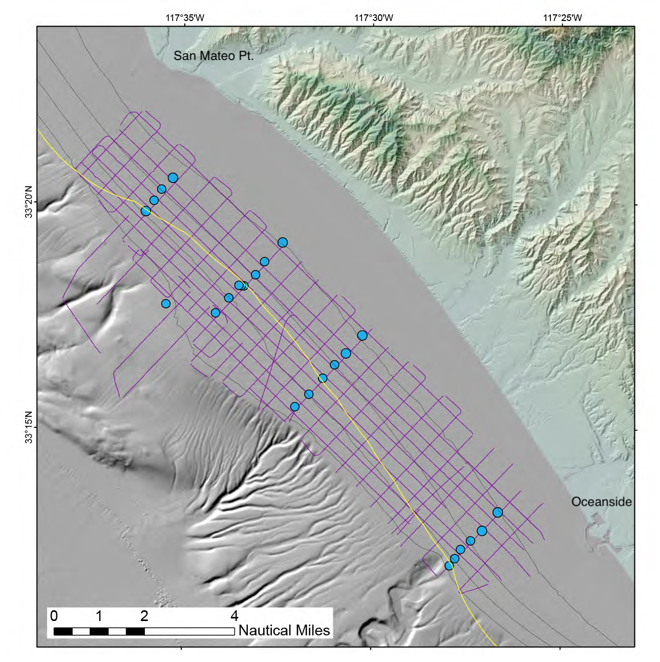
The U.S. Geological Survey (USGS) collected high-resolution chirp seismic-reflection profiles in 2017 offshore Oceanside, southern California. The goal of the chirp survey was to provide high-resolution imaging to characterize the surface and subsurface properties of the study area, including unconsolidated sediment thickness and subsurface sediment horizons. This cruise was funded through partnerships with the Bureau of Ocean Energy Management (BOEM) and the State of California Ocean Protection Council (OPC).

How was the data set created?

  1. From what previous works were the data drawn?
  2. How were the data generated, processed, and modified?
    Date: 31-Oct-2017 (process 1 of 2)
    The chirp seismic-reflection profiles were acquired with a swept frequency source towed at 4 to 11 meters depth below the sea surface and fired at roughly every 1 to 2 meters, depending on water depth. Data were recorded to Edgetech JSF format using Edgetech recording software. Survey speeds were approximately 4.5 knots.
    Date: 15-Nov-2017 (process 2 of 2)
    Chirp seismic-reflection data were first converted from JSF to SEG-Y format. The SEG-Y files were then processed using Echos by Paradigm Geophysical. The following processing steps were applied to each line: 1)The fish depth header word was read and converted from millimeters to two-way travel time to create a fish-depth static value; 2) The fish depth static was applied to the data to correct for changing tow depth of Chirp fish; 3) an additional a Paradigm Echos smoothing module was applied to the data to correct for the motion of the sea; and 4) final processed SEG-Y was output with correct navigation written to header bytes 81 and 85 in UTM zone 11N coordinates with a scalar value of 1. The scalar value located in header byte 71 only applies to arcsecond values in headers bytes 73 and 77. These data are divided up and presented by navigation line, as reflected in the individual file names.
  3. What similar or related data should the user be aware of?

How reliable are the data; what problems remain in the data set?

  1. How well have the observations been checked?
    Identified as best available version. Due to horizontal amplitude variation at the seafloor, the swell correction module output anomalous static shifts that could not be improved upon. These lines are: 2, 2L, 3, 5, 06, 7, 8, 9, 10, 13, 19, 20 and 22A.
  2. How accurate are the geographic locations?
    Position data were provided by a Hemisphere V100 Global Positioning System using L1, C/A code and carrier phase smoothing with a stated accuracy of 60 centimeters.
  3. How accurate are the heights or depths?
    Depths shown in the seismic data files are in milliseconds (round trip travel time) and are referenced to sea level.
  4. Where are the gaps in the data? What is missing?
    Dataset is considered complete for the information presented, as described in the abstract. Users are advised to read the rest of the metadata record carefully for additional details. Equipment malfunction or shutdowns due to mammals in the area resulted in some lines having multiple parts.
  5. How consistent are the relationships among the observations, including topology?
    Subbottom data were collected during USGS cruise 2017-686-FA using an Edgetech 512 Chirp sub-bottom profiling system. This system consists of a source transducer and an array of receiving hydrophones housed in a 500-lb “fish” towed at a depth of several meters below the sea surface. The swept-frequency “chirp” source signal is between 500 and 4,500 Hz, and data are recorded by hydrophones located on the bottom of the fish. Quality control was conducted during the collection process.

How can someone get a copy of the data set?

Are there legal restrictions on access or use of the data?
Access_Constraints: None
Use_Constraints:
USGS-authored or produced data and information are in the public domain from the U.S. Government and are freely redistributable with proper metadata and source attribution. Please recognize and acknowledge the U.S. Geological Survey as the originator of the dataset and in products derived from these data. This information is not intended for navigation purposes.
  1. Who distributes the data set? (Distributor 1 of 1)
    U.S. Geological Survey – Pacific Coastal and Marine Science Center
    2885 Mission Street
    Santa Cruz, CA

    1-831-427-4747 (voice)
    pcmsc_data@usgs.gov
  2. What's the catalog number I need to order this data set? 2017-686-FA_chirp.zip contains high-resolution seismic-reflection (SEG-Y) data collected during PCMSC field activity 2017-686-FA. These data are divided up and presented by navigation line, as reflected in the individual file names.
  3. What legal disclaimers am I supposed to read?
    Unless otherwise stated, all data, metadata and related materials are considered to satisfy the quality standards relative to the purpose for which the data were collected. Although these data and associated metadata have been reviewed for accuracy and completeness and approved for release by the U.S. Geological Survey (USGS), no warranty expressed or implied is made regarding the display or utility of the data on any other system or for general or scientific purposes, nor shall the act of distribution constitute any such warranty.
  4. How can I download or order the data?
  5. What hardware or software do I need in order to use the data set?
    Use of SEG-Y data requires specialized software, such as ProMax and Seisworks by Landmark Geophysical; FOCUS and SeisX by Paradigm Geophysical; SPW by Parallel Geoscience; VISTA by Seismic Image Software; SeiSee by Dalmorneftegeophysica (DMNG); amongst others.

Who wrote the metadata?

Dates:
Last modified: 17-Mar-2021
Metadata author:
U.S. Geological Survey, Pacific Coastal and Marine Science Center
Attn: PCMSC Science Data Coordinator
2885 Mission Street
Santa Cruz, CA

831-460-4747 (voice)
pcmsc_data@usgs.gov
Metadata standard:
Content Standard for Digital Geospatial Metadata (FGDC-STD-001-1998)

This page is <https://cmgds.marine.usgs.gov/catalog/pcmsc/DataReleases/CMGDS_DR_tool/DR_P9UELSBU/2017-686-FA_chirp_metadata.faq.html>
Generated by mp version 2.9.50 on Tue Sep 21 18:17:09 2021