Citation:
Citation_Information:
Originator: Ray W. Sliter
Originator: James E. Conrad
Originator: Thomas D. Lorenson
Originator: Antoinette G. Papesh
Originator: Janet T. Watt
Originator: Jonathan A. Warrick
Publication_Date: 2021
Title:
High-resolution chirp seismic-reflection data collected offshore Oceanside, southern California during field activity 2017-686-FA from 2017-10-23 to 2017-10-31
Geospatial_Data_Presentation_Form: seismic-reflection data in SEG-Y format
Series_Information:
Series_Name: data release
Issue_Identification: DOI:10.5066/P9UELSBU
Publication_Information:
Publication_Place:
Pacific Coastal and Marine Science Center, Santa Cruz, California
Publisher: U.S. Geological Survey
Online_Linkage: https://doi.org/10.5066/P9UELSBU
Online_Linkage:
Larger_Work_Citation:
Citation_Information:
Originator: Ray W. Sliter
Originator: James E. Conrad
Originator: Thomas D. Lorenson
Originator: Antoinette G. Papesh
Originator: Janet T. Watt
Originator: Jonathan A. Warrick
Publication_Date: 2021
Title:
Geophysical and sampling data collected offshore Oceanside, southern California during field activity 2017-686-FA from 2017-10-23 to 2017-10-31
Series_Information:
Series_Name: data release
Issue_Identification: DOI:10.5066/P9UELSBU
Publication_Information:
Publication_Place: Pacific Coastal and Marine Science Center, Santa Cruz, CA
Publisher: U.S. Geological Survey
Online_Linkage: https://doi.org/10.5066/P9UELSBU
Description:
Abstract:
This section of the data release contains approximately 369 line-kilometers of processed, high-resolution chirp seismic-reflection profiles that were collected aboard the R/V Snavely in 2017 on U.S. Geological Survey cruise 2017-686-FA offshore Oceanside, southern California. The along-shore and across-shore chirp profiles are oriented to assess sand and gravel resources in Federal and State waters for potential use in future beach nourishment projects along stretches of the coast where critical erosion hotspots have been identified. The chirp profiles were acquired using an Edgetech 512 Chirp sub-bottom profiling system.
Purpose:
The U.S. Geological Survey (USGS) collected high-resolution chirp seismic-reflection profiles in 2017 offshore Oceanside, southern California. The goal of the chirp survey was to provide high-resolution imaging to characterize the surface and subsurface properties of the study area, including unconsolidated sediment thickness and subsurface sediment horizons. This cruise was funded through partnerships with the Bureau of Ocean Energy Management (BOEM) and the State of California Ocean Protection Council (OPC).
Supplemental_Information:
Additional information about the field activity from which these data were derived is available online at:
https://cmgds.marine.usgs.gov/fan_info.php?fan=2017-686-FA
Any use of trade, product, or firm names is for descriptive purposes only and does not imply endorsement by the U.S. Government.
Time_Period_of_Content:
Time_Period_Information:
Range_of_Dates/Times:
Beginning_Date: 20171017
Ending_Date: 20171031
Currentness_Reference: ground condition at time data were collected
Status:
Progress: Planned
Maintenance_and_Update_Frequency: As needed
Spatial_Domain:
Bounding_Coordinates:
West_Bounding_Coordinate: -117.53036
East_Bounding_Coordinate: -117.40898
North_Bounding_Coordinate: 33.29839
South_Bounding_Coordinate: 33.21621
Keywords:
Theme:
Theme_Keyword_Thesaurus: USGS Metadata Identifier
Theme_Keyword: USGS:487fe2c1-c197-45b2-82f3-58f30d8d8c2c
Theme:
Theme_Keyword_Thesaurus: ISO 19115 Topic Category
Theme_Keyword: oceans
Theme_Keyword: geoscientificInformation
Theme:
Theme_Keyword_Thesaurus: Data Categories for Marine Planning
Theme_Keyword: Bathymetry and Elevation
Theme:
Theme_Keyword_Thesaurus: USGS Thesaurus
Theme_Keyword: sub-bottom profiling
Theme_Keyword: marine geophysics
Theme_Keyword: geospatial datasets
Theme:
Theme_Keyword_Thesaurus: Marine Realms Information Bank (MRIB) keywords
Theme_Keyword: seismic reflection profiling
Theme:
Theme_Keyword_Thesaurus: None
Theme_Keyword: U.S. Geological Survey
Theme_Keyword: USGS
Theme_Keyword: Coastal and Marine Hazards and Resources Program
Theme_Keyword: CMHRP
Theme_Keyword: Pacific Coastal and Marine Science Center
Theme_Keyword: PCMSC
Place:
Place_Keyword_Thesaurus: Geographic Names Information System (GNIS)
Place_Keyword: Pacific Ocean
Place_Keyword: State of California
Place_Keyword: Oceanside
Place_Keyword: San Mateo Point
Place:
Place_Keyword_Thesaurus: NGA GEOnet Names Server (GNS)
Place_Keyword: North Pacific Ocean
Access_Constraints: None
Use_Constraints:
USGS-authored or produced data and information are in the public domain from the U.S. Government and are freely redistributable with proper metadata and source attribution. Please recognize and acknowledge the U.S. Geological Survey as the originator of the dataset and in products derived from these data. This information is not intended for navigation purposes.
Point_of_Contact:
Contact_Information:
Contact_Organization_Primary:
Contact_Organization:
U.S. Geological Survey, Pacific Coastal and Marine Science Center
Contact_Person: PCMSC Science Data Coordinator
Contact_Address:
Address_Type: mailing and physical
Address: 2885 Mission Street
City: Santa Cruz
State_or_Province: CA
Postal_Code: 95060
Contact_Voice_Telephone: 831-460-4747
Contact_Electronic_Mail_Address: [email protected]
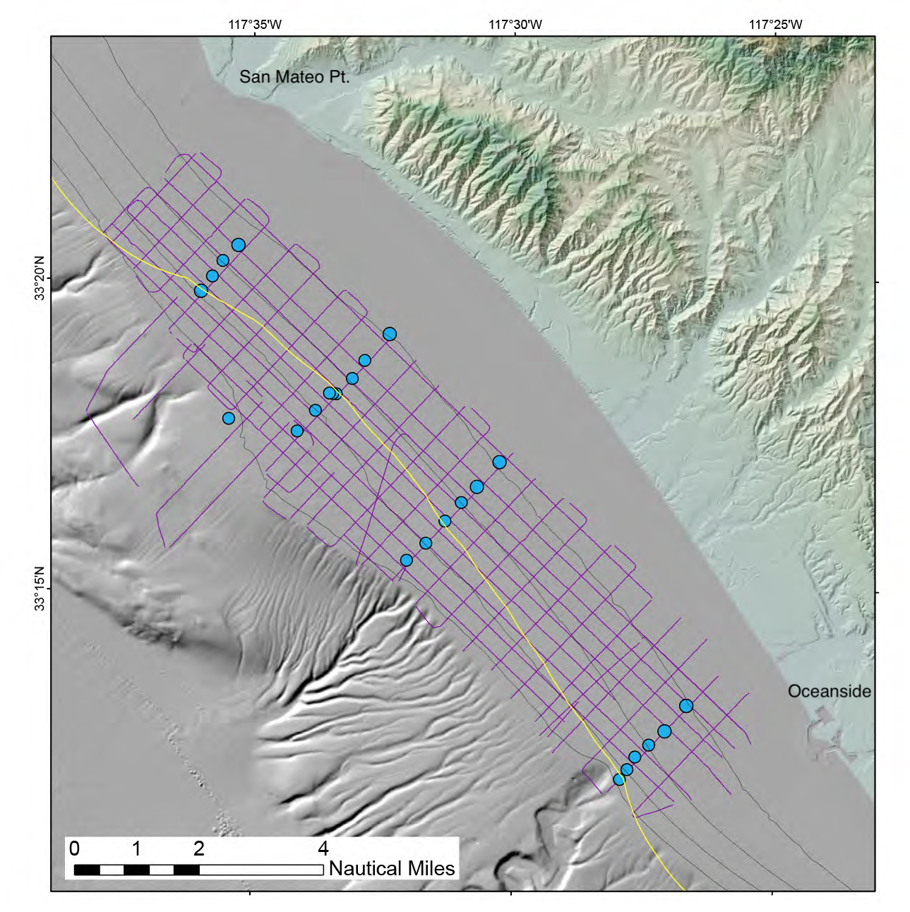
Browse_Graphic:
Browse_Graphic_File_Name:
Browse_Graphic_File_Description:
Map showing tracklines along which chirp seismic data were collected
Browse_Graphic_File_Type: PNG
Native_Data_Set_Environment: SEG-Y Rev 1