Citation:
Citation_Information:
Originator: Olivia A. De Meo
Originator: Steven E. Suttles
Originator: Eric D. Marsjanik
Originator: Robert D. Bales
Originator: Christopher R. Sherwood
Publication_Date: 20260108
Title:
Time-series measurements of oceanographic data collected in the nearshore zone offshore of Marconi Beach, Wellfleet, MA, December 9, 2024 to March 10, 2025
Edition: 1.0
Geospatial_Data_Presentation_Form: netCDF
Series_Information:
Series_Name: data release
Issue_Identification: DOI:10.5066/P13KF7UW
Publication_Information:
Publication_Place:
Woods Hole Coastal and Marine Science Center, Woods Hole, Massachusetts
Publisher: U.S. Geological Survey
Other_Citation_Details:
Suggested citation: De Meo, O.A., Suttles, S.E., Marsjanik, E.D., Bales, R.D., and Sherwood, C.R., 2026, Time-series measurements of oceanographic data collected in the nearshore zone offshore of Marconi Beach, Wellfleet, MA, December 9, 2024 to March 10, 2025: U.S. Geological Survey data release,
https://doi.org/10.5066/P13KF7UW.
Description:
Abstract:
The U.S. Geological Survey (USGS) Woods Hole Coastal and Marine Science Center deployed a four-legged bottom landing frame (nanopod) containing oceanographic instruments to collect measurements of winter wave conditions directly offshore of Marconi Beach in Wellfleet, MA. Supplementary sediment samples were collected to characterize grain size. Marconi Beach is the site of ongoing measurements of wave runup, and this field work provides information on the incident waves and water levels that are ultimately responsible for wave runup on the beach. Maps of subaerial topography and nearshore bathymetry were made to augment the wave and runup measurements. These observations will allow us to test and validate models of wave shoaling and transformation and generation of wave runup. The larger objective of this work is to provide validation and indicate needed improvements for the Total Water Level and Coastal Change forecasts made publicly available in real time by the USGS. These forecasts provide information that emergency managers and the American public can use to help safeguard coastal property, businesses, energy production and distribution facilities, and national security installations.
Purpose:
A submerged nanopod was deployed to collect time series data of temperature, conductivity, salinity, seabed height, pressure, water velocity and acoustic surface tracking.
Supplemental_Information:
Time_Period_of_Content:
Time_Period_Information:
Range_of_Dates/Times:
Beginning_Date: 20241209
Ending_Date: 20250310
Currentness_Reference: ground condition at time data were collected
Status:
Progress: Complete
Maintenance_and_Update_Frequency: None planned
Spatial_Domain:
Bounding_Coordinates:
West_Bounding_Coordinate: -69.94247
East_Bounding_Coordinate: -69.94247
North_Bounding_Coordinate: 41.89786
South_Bounding_Coordinate: 41.89786
Keywords:
Theme:
Theme_Keyword_Thesaurus: USGS Metadata Identifier
Theme_Keyword: USGS:bd70bee2-7ee8-43ee-a4d8-2f04487a5bb3
Theme:
Theme_Keyword_Thesaurus: ISO 19115 Topic Category
Theme_Keyword: geoscientificInformation
Theme_Keyword: oceans
Theme:
Theme_Keyword_Thesaurus: USGS Thesaurus
Theme_Keyword: time series datasets
Theme_Keyword: ocean salinity
Theme_Keyword: water temperature
Theme_Keyword: ocean currents
Theme_Keyword: ocean waves
Theme_Keyword: surface-water level
Theme_Keyword: water quality
Theme_Keyword: ocean sciences
Theme:
Theme_Keyword_Thesaurus: None
Theme_Keyword: U.S. Geological Survey
Theme_Keyword: CMHRP
Theme_Keyword: Woods Hole Coastal and Marine Science Center
Place:
Place_Keyword_Thesaurus: Common geographic areas
Place_Keyword: Massachusetts
Place_Keyword: Atlantic
Place:
Place_Keyword_Thesaurus: Geographic Names Information System (GNIS)
Place_Keyword: Atlantic Ocean
Place_Keyword: Marconi Beach
Access_Constraints:
No access constraints. Please see 'Distribution Information' for details.
Use_Constraints:
These data are marked with a Creative Commons Zero v1.0 Universal (CC0-1.0) public domain dedication and do not have any use constraints. Users are advised to read the dataset's metadata thoroughly to understand appropriate use and data limitations. USGS-authored or produced data and information are in the public domain from the U.S. Government and are freely redistributable with proper metadata and source attribution. Please recognize and acknowledge the U.S. Geological Survey as the originator(s) of the dataset and in products derived from these data.
Point_of_Contact:
Contact_Information:
Contact_Person_Primary:
Contact_Person: Olivia A. De Meo
Contact_Organization: U.S. Geological Survey, Northeast Region
Contact_Position: Physical Scientist
Contact_Address:
Address_Type: mailing address
Address: 384 Woods Hole Road
City: Woods Hole
State_or_Province: MA
Postal_Code: 02543
Country: US
Contact_Voice_Telephone: 508-548-8700 x2356
Contact_Electronic_Mail_Address: [email protected]
Contact_Instructions:
The contact email address is a generic address in the event the person is no longer with USGS.
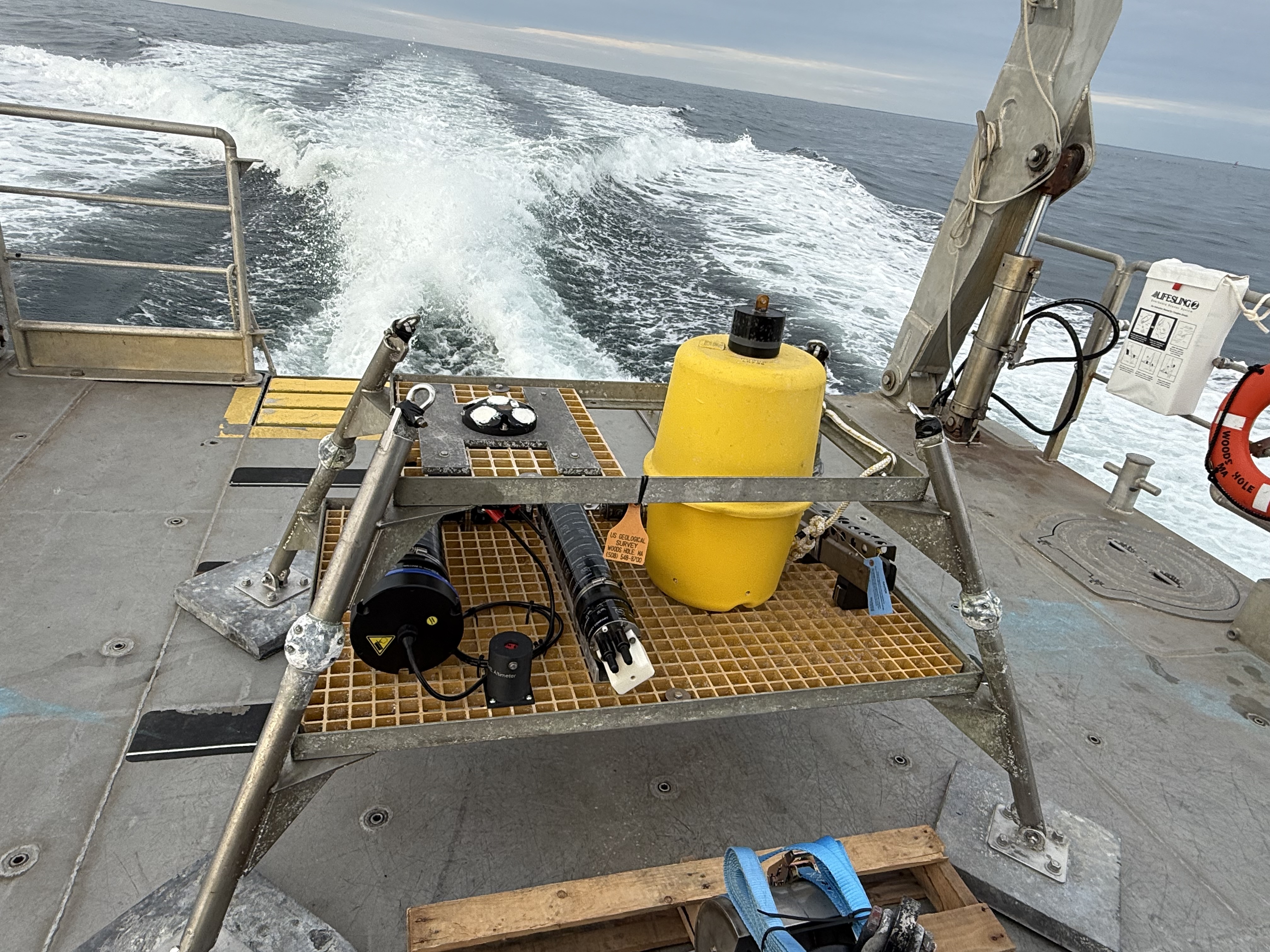
Browse_Graphic:
Browse_Graphic_File_Name:
Browse_Graphic_File_Description: Photo of nanopod with attached sensors.
Browse_Graphic_File_Type: JPEG
Cross_Reference:
Citation_Information:
Originator: Olivia A. De Meo
Originator: Steven E. Suttles
Originator: Eric D. Marsjanik
Originator: Robert D. Bales
Originator: Chris R. Sherwood
Publication_Date: 2025
Title:
Grain-size analysis of sediment samples collected in the nearshore zone offshore of Marconi Beach, Wellfleet, MA, December 9, 2024
Geospatial_Data_Presentation_Form: tabular digital data
Series_Information:
Series_Name: data release
Issue_Identification: DOI:10.5066/P14KORS8
Publication_Information:
Publication_Place:
Woods Hole Coastal and Marine Science Center, Woods Hole, Massachusetts
Publisher: U.S. Geological Survey
Online_Linkage: https://doi.org/10.5066/P14KORS8
Cross_Reference:
Citation_Information:
Originator: Daniel J. Nowacki
Originator: Steven E. Suttles
Originator: Robert D. Bales
Originator: Olivia A. De Meo
Publication_Date: 2024
Title: stglib: Oceanographic Time Series Data Processing Library
Geospatial_Data_Presentation_Form: application/service
Series_Information:
Series_Name: U.S. Geological Survey software release
Issue_Identification: DOI:10.5066/P13IQYFW
Publication_Information:
Publication_Place: Reston, VA
Publisher: U.S. Geological Survey
Online_Linkage: https://doi.org/10.5066/P13IQYFW