Online Links:
Online Links:
| Range of values | |
|---|---|
| Minimum: | 41.752861 |
| Maximum: | 42.012512 |
| Units: | decimal degrees |
| Resolution: | 0.000001 |
| Range of values | |
|---|---|
| Minimum: | -70.493237 |
| Maximum: | -70.135025 |
| Units: | decimal degrees |
| Resolution: | 0.000001 |
| Range of values | |
|---|---|
| Minimum: | -37.7 |
| Maximum: | -12.1 |
| Units: | meters |
| Resolution: | 0.1 |
| Range of values | |
|---|---|
| Minimum: | 0 |
| Maximum: | 0 |
| Units: | centimeters |
| Range of values | |
|---|---|
| Minimum: | 2 |
| Maximum: | 2 |
| Units: | centimeters |
| Range of values | |
|---|---|
| Minimum: | 24.3080 |
| Maximum: | 247.5464 |
| Units: | grams |
| Resolution: | 0.0001 |
| Range of values | |
|---|---|
| Minimum: | 0 |
| Maximum: | 1.3650 |
| Units: | grams |
| Resolution: | 0.0001 |
| Range of values | |
|---|---|
| Minimum: | 0 |
| Maximum: | 65.4773 |
| Units: | weight percent |
| Resolution: | 0.0001 |
| Range of values | |
|---|---|
| Minimum: | 2.5424 |
| Maximum: | 99.4846 |
| Units: | weight percent |
| Resolution: | 0.0001 |
| Range of values | |
|---|---|
| Minimum: | 0.3406 |
| Maximum: | 66.3161 |
| Units: | weight percent |
| Resolution: | 0.0001 |
| Range of values | |
|---|---|
| Minimum: | 0.0027 |
| Maximum: | 53.5872 |
| Units: | weight percent |
| Resolution: | 0.0001 |
| Value | Definition |
|---|---|
| clayey sand | Sediment whose main phase is sand, but with significant clay. |
| clayey silt | Sediment whose main phase is silt, but with significant clay. |
| gravel | Sediment whose main phase is gravel. |
| gravelly sediment | Sediment whose main phase is gravel, but with significant other sediment. Gravel greater than 10 percent. |
| sand | Sediment whose main phase is sand. |
| sand silt clay | Sediment with significant (over 20 percent) sand, silt, and clay. |
| sandy silt | Sediment whose main phase is silt, but with significant sand. |
| silty clay | Sediment whose main phase is clay, but with significant silt. |
| silty sand | Sediment whose main phase is sand, but with significant silt. |
| Range of values | |
|---|---|
| Minimum: | -3.19 |
| Maximum: | 8.15 |
| Units: | phi |
| Resolution: | 0.01 |
| Range of values | |
|---|---|
| Minimum: | -1.86 |
| Maximum: | 7.56 |
| Units: | phi |
| Resolution: | 0.01 |
| Range of values | |
|---|---|
| Minimum: | 0.69 |
| Maximum: | 3.63 |
| Units: | phi |
| Resolution: | 0.01 |
| Range of values | |
|---|---|
| Minimum: | -0.96 |
| Maximum: | 4.99 |
| Units: | phi |
| Resolution: | 0.01 |
| Range of values | |
|---|---|
| Minimum: | 0.75 |
| Maximum: | 48.77 |
| Units: | phi |
| Resolution: | 0.01 |
| Range of values | |
|---|---|
| Minimum: | 0 |
| Maximum: | 0 |
| Units: | weight percent |
| Resolution: | 0.001 |
| Range of values | |
|---|---|
| Minimum: | 0 |
| Maximum: | 0 |
| Units: | weight percent |
| Resolution: | 0.001 |
| Range of values | |
|---|---|
| Minimum: | 0 |
| Maximum: | 8.284 |
| Units: | weight percent |
| Resolution: | 0.001 |
| Range of values | |
|---|---|
| Minimum: | 0 |
| Maximum: | 21.929 |
| Units: | weight percent |
| Resolution: | 0.001 |
| Range of values | |
|---|---|
| Minimum: | 0 |
| Maximum: | 26.939 |
| Units: | weight percent |
| Resolution: | 0.001 |
| Range of values | |
|---|---|
| Minimum: | 0.062 |
| Maximum: | 31.069 |
| Units: | weight percent |
| Resolution: | 0.001 |
| Range of values | |
|---|---|
| Minimum: | 0.110 |
| Maximum: | 21.728 |
| Units: | weight percent |
| Resolution: | 0.001 |
| Range of values | |
|---|---|
| Minimum: | 0.093 |
| Maximum: | 20.025 |
| Units: | weight percent |
| Resolution: | 0.001 |
| Range of values | |
|---|---|
| Minimum: | 0.067 |
| Maximum: | 26.248 |
| Units: | weight percent |
| Resolution: | 0.001 |
| Range of values | |
|---|---|
| Minimum: | 0.257 |
| Maximum: | 68.259 |
| Units: | weight percent |
| Resolution: | 0.001 |
| Range of values | |
|---|---|
| Minimum: | 0.222 |
| Maximum: | 70.600 |
| Units: | weight percent |
| Resolution: | 0.001 |
| Range of values | |
|---|---|
| Minimum: | 0.063 |
| Maximum: | 72.611 |
| Units: | weight percent |
| Resolution: | 0.001 |
| Range of values | |
|---|---|
| Minimum: | 0.003 |
| Maximum: | 80.865 |
| Units: | weight percent |
| Resolution: | 0.001 |
| Range of values | |
|---|---|
| Minimum: | 0 |
| Maximum: | 28.455 |
| Units: | weight percent |
| Resolution: | 0.001 |
| Range of values | |
|---|---|
| Minimum: | 0 |
| Maximum: | 4.689 |
| Units: | weight percent |
| Resolution: | 0.001 |
| Range of values | |
|---|---|
| Minimum: | 0 |
| Maximum: | 6.217 |
| Units: | weight percent |
| Resolution: | 0.001 |
| Range of values | |
|---|---|
| Minimum: | 0 |
| Maximum: | 24.644 |
| Units: | weight percent |
| Resolution: | 0.001 |
| Range of values | |
|---|---|
| Minimum: | 0 |
| Maximum: | 2.732 |
| Units: | weight percent |
| Resolution: | 0.001 |
| Range of values | |
|---|---|
| Minimum: | 0 |
| Maximum: | 27.195 |
| Units: | weight percent |
| Resolution: | 0.001 |
Online Links:
Online Links:
Online Links:
Online Links:
Online Links:
| Access_Constraints | None |
|---|---|
| Use_Constraints | Public domain data from the U.S. Government are freely redistributable with proper metadata and source attribution. Please recognize the U.S. Geological Survey as the originator of the dataset. |
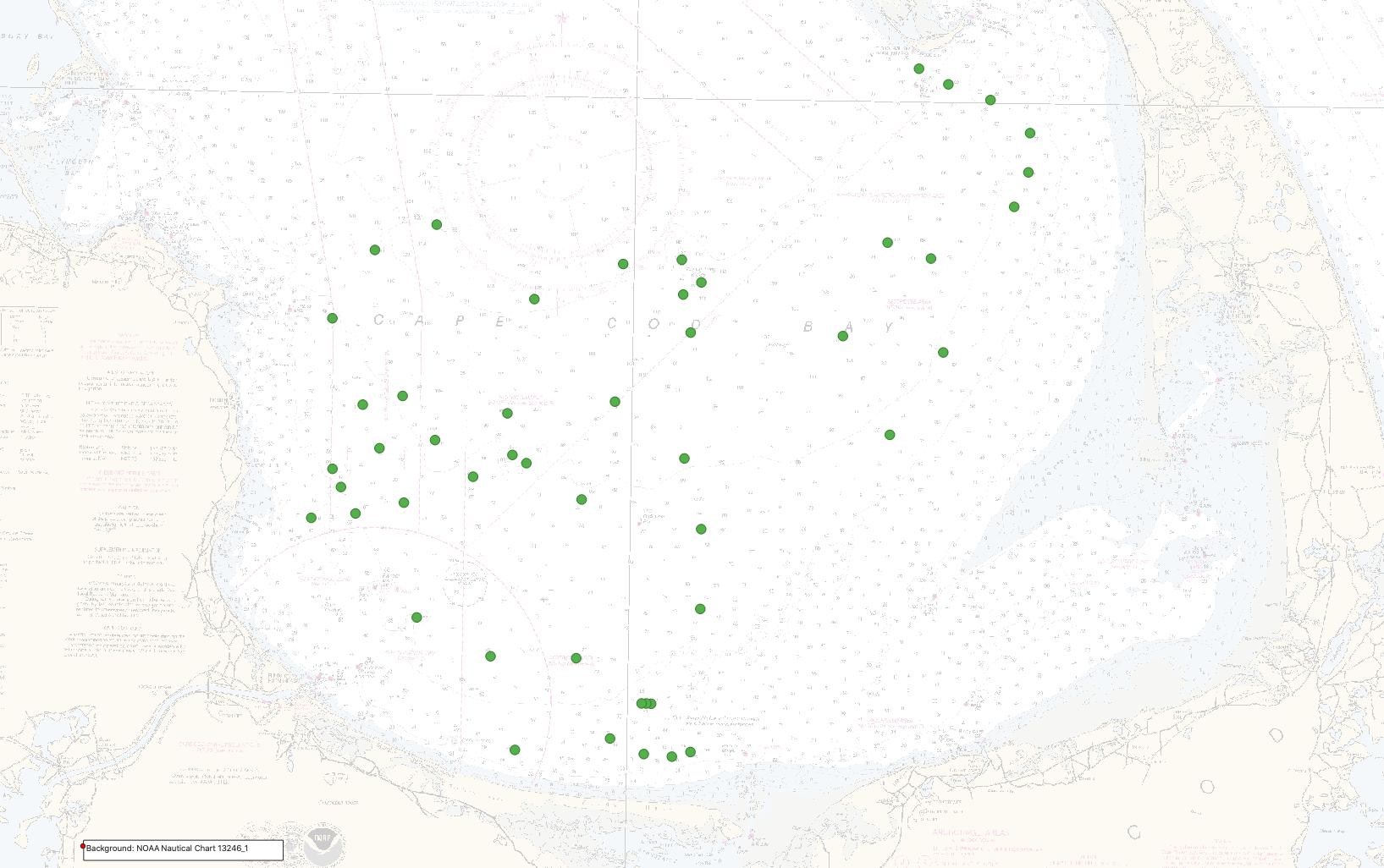
| Data format: | This dataset contains a CSV file and shapefile of locations and grain-size analysis results for sediment samples collected by the U.S. Geological Survey in Cape Cod Bay, Massachusetts, in September 2019. The transfer size of the data in a zip file is 0.01 MB. in format Comma-delimited text (version Microsoft Excel 2016 for Mac) Comma Separated Values (CSV) text file Size: 0.01 |
|---|---|
| Network links: |
https://cmgds.marine.usgs.gov/data-releases/media/2021/10.5066-P99DR4PN/a545d0570b2846a789dfa2aba46d2163/2019-034-FA_samples.zip https://cmgds.marine.usgs.gov/data-releases/datarelease/10.5066-P99DR4PN/ https://doi.org/10.5066/P99DR4PN |
| Data format: | This dataset contains a CSV file and shapefile of locations and grain-size analysis results for sediment samples collected by the U.S. Geological Survey in Cape Cod Bay, Massachusetts, in September 2019. The transfer size of the data in a zip file is 0.01 MB. in format Shapefile (version Esri ArcGIS Pro 2.4.1) Shapefile Size: 0.01 |
|---|---|
| Network links: |
https://cmgds.marine.usgs.gov/data-releases/media/2021/10.5066-P99DR4PN/a545d0570b2846a789dfa2aba46d2163/2019-034-FA_samples.zip https://cmgds.marine.usgs.gov/data-releases/datarelease/10.5066-P99DR4PN/ https://doi.org/10.5066/P99DR4PN |