Multibeam sonar tracklines collected during USGS field activity 2021-004-FA, using a dual-head Teledyne SeaBat T20-P multibeam echo sounder (Esri polyline shapefile, GCS WGS 84)

Metadata also available as - [Questions & Answers] - [Parseable text] - [XML]

Metadata:

Identification_Information:
Citation:
Citation_Information:
Originator: Seth D. Ackerman
Publication_Date: 20231114
Title:
Multibeam sonar tracklines collected during USGS field activity 2021-004-FA, using a dual-head Teledyne SeaBat T20-P multibeam echo sounder (Esri polyline shapefile, GCS WGS 84)
Edition: 1.0
Geospatial_Data_Presentation_Form: vector digital data
Series_Information:
Series_Name: data release
Issue_Identification: DOI:10.5066/P9GO90TI
Publication_Information:
Publication_Place:
Woods Hole Coastal and Marine Science Center, Woods Hole, Massachusetts
Publisher:
U.S. Geological Survey, Coastal and Marine Hazards and Resources Program
Online_Linkage: https://doi.org/10.5066/P9GO90TI
Online_Linkage: Larger_Work_Citation:
Citation_Information:
Originator: Seth D. Ackerman
Originator: David S. Foster
Originator: Charles R. Worley
Originator: Alexander R. Nichols
Publication_Date: 2023
Title:
High-resolution geophysical and geological data collected from outer Cape Cod, Massachusetts during USGS Field Activity 2021-004-FA
Edition: 1.0
Series_Information:
Series_Name: data release
Issue_Identification: DOI:10.5066/P9GO90TI
Publication_Information:
Publication_Place: Reston, VA
Publisher: U.S. Geological Survey
Other_Citation_Details:
Suggested citation: Ackerman, S.D., Foster, D.S., Worley, C.R., and Nichols, A.R., 2023, High-resolution geophysical and geological data collected from outer Cape Cod, Massachusetts during USGS Field Activity 2021-004-FA: U.S. Geological Survey data release, https://doi.org/10.5066/P9GO90TI.
Online_Linkage: https://doi.org/10.5066/P9GO90TI
Online_Linkage:
Description:
Abstract:
The U.S. Geological Survey (USGS) Woods Hole Coastal and Marine Science Center (WHCMSC) completed a bathymetric and shallow seismic-reflection survey during the period of June 9, 2021 to June 24, 2021 in water depths from 2 m to 30 m for a portion of the outer Cape Cod nearshore environment between Marconi and Nauset Beaches. The products from this survey will help to support white shark research on their shallow-water behavior in the dynamic nearshore environment at Cape Cod National Seashore (CACO). CACO visitors’ safety is threatened by interactions between the public and white sharks. This project provides CACO with baseline data and information on nearshore white shark habitat, specifically in the nearshore shoreface, bathymetric trough, and longshore bar. This data release provides the geophysical data collected from outer Cape Cod during USGS Field Activities 2021-002-FA in 2021.
Purpose:
This dataset contains a polyline shapefile representing the trackline navigation for approximately 358 kilometers of multibeam echo sounder bathymetry and backscatter data collected by the U.S. Geological Survey during survey 2021-004-FA from outer Cape Cod, Massachusetts. This information can help spatially correlate the bathymetry and backscatter data with other geophysical data.
Supplemental_Information:
Support for 2021-004-FA was provided to the USGS from the National Park Service, Cape Cod National Seashore. Additional information on the field activities associated with this project are available at https://cmgds.marine.usgs.gov/fan_info.php?fan=2021-004-FA
Time_Period_of_Content:
Time_Period_Information:
Range_of_Dates/Times:
Beginning_Date: 20210609
Ending_Date: 20210624
Currentness_Reference: ground condition
Status:
Progress: Complete
Maintenance_and_Update_Frequency: None planned
Spatial_Domain:
Bounding_Coordinates:
West_Bounding_Coordinate: -69.97780
East_Bounding_Coordinate: -69.91390
North_Bounding_Coordinate: 41.94270
South_Bounding_Coordinate: 41.78360
Keywords:
Theme:
Theme_Keyword_Thesaurus: USGS Metadata Identifier
Theme_Keyword: USGS:4ce1ef63-6235-42b8-ab6b-07040696b943
Theme:
Theme_Keyword_Thesaurus: None
Theme_Keyword: U.S. Geological Survey
Theme_Keyword: USGS
Theme_Keyword: Woods Hole Coastal and Marine Science Center
Theme_Keyword: WHCMSC
Theme_Keyword: Coastal and Marine Hazards and Resources Program
Theme_Keyword: CMHRP
Theme_Keyword: Department of the Interior
Theme_Keyword: DOI
Theme_Keyword: Cape Cod National Seashore
Theme_Keyword: CACO
Theme_Keyword: National Park Service
Theme_Keyword: NPS
Theme_Keyword: Massachusetts Office of Coastal Zone Management
Theme_Keyword: CZM
Theme_Keyword: MassCZM
Theme_Keyword: field activity number 2021-004-FA
Theme_Keyword: RV Rafael
Theme_Keyword: shapefile
Theme_Keyword: multibeam echo sounder
Theme_Keyword: multibeam bathymetry
Theme_Keyword: multibeam backscatter
Theme_Keyword: Reson
Theme_Keyword: Teledyne SeaBat
Theme_Keyword: T20P
Theme_Keyword: bathymetry
Theme_Keyword: backscatter
Theme_Keyword: Marine Geology
Theme:
Theme_Keyword_Thesaurus: ISO 19115 Topic Category
Theme_Keyword: oceans
Theme_Keyword: geoscientificInformation
Theme:
Theme_Keyword_Thesaurus: USGS Thesaurus
Theme_Keyword: multibeam sonar
Theme_Keyword: marine geophysics
Theme_Keyword: marine geology
Theme_Keyword: navigational data
Theme_Keyword: geospatial datasets
Place:
Place_Keyword_Thesaurus: None
Place_Keyword: United States of America
Place_Keyword: Atlantic Ocean
Place_Keyword: Atlantic Margin
Place_Keyword: Cape Cod
Place_Keyword: Massachusetts
Place_Keyword: Orleans
Place_Keyword: Eastham
Place_Keyword: Wellfleet
Place_Keyword: Marconi Beach
Place_Keyword: Nauset Beach
Stratum:
Stratum_Keyword_Thesaurus: None
Stratum_Keyword: sea floor
Stratum_Keyword: seafloor
Temporal:
Temporal_Keyword_Thesaurus: none
Temporal_Keyword: 2021
Access_Constraints: none
Use_Constraints:
Public domain data from the U.S. Government are freely distributable with proper metadata and source attribution. Please recognize the U.S. Geological Survey as the originator of the dataset.
Point_of_Contact:
Contact_Information:
Contact_Person_Primary:
Contact_Person: Seth Ackerman
Contact_Organization: U.S. Geological Survey
Contact_Position: Geologist
Contact_Address:
Address_Type: mailing and physical address
Address: 384 Woods Hole Rd.
City: Woods Hole
State_or_Province: MA
Postal_Code: 02543-1598
Country: USA
Contact_Voice_Telephone: 508-548-8700 x2315
Contact_Facsimile_Telephone: 508-457-2310
Contact_Electronic_Mail_Address: sackerman@usgs.gov
Browse_Graphic:
Browse_Graphic_File_Name: Browse_Graphic_File_Description:
Thumbnail image of multibeam echo sounder tracklines collected from outer Cape Cod, Massachusetts.
Browse_Graphic_File_Type: JPEG
Data_Quality_Information:
Logical_Consistency_Report:
Multibeam echo sounder (MBES) data were collected during survey operations in June 2021. Acquisition may have been suspended briefly during file changes or for longer periods during turns and system calibration, malfunction, or troubleshooting system issues. Any gaps between the polyline features in this shapefile reflect those time periods where data were not recorded.
This trackline shapefile was created from the bathymetry data processed in Computer Aided Resource Information System Hydrographic Information Processing System CARIS HIPS version 11.3 using Hysweep HSX raw sonar files. Note that backscatter imagery (processed in QPS FMGT version 7.8.9) was created using the Teledyne SeaBat UI s7k raw files (M_ and S_ survey lines) that were collected simultaneously with the Hysweep HSX files. This polyline shapefile only represents the HSX tracklines which are generally the same extent as the s7k tracks. The s7k (M_ and S_) sonar files are mostly coincident with each other, although they can become unsynchronized. Any small timing offset only affects the timing of survey file changes and the resulting line names, not the quality of the data.
Completeness_Report:
Data were collected on the following dates: 20210609 and 20210615-20210624 (Julian day 160 and 166-175); several lines of bathymetry data was collected on 20210609 (Julian day 160) while the survey team was out testing the seismic system before the formal start of the survey. Data collected during some turns were excluded from the final bathymetry dataset and backscatter mosaic. However, the patch test tracklines and tracklines that extend beyond the survey area are all included in this shapefile.
Positional_Accuracy:
Horizontal_Positional_Accuracy:
Horizontal_Positional_Accuracy_Report:
Navigation data were acquired using the WGS 84 coordinate system with an Applanix POS MV Wavemaster (model 220, V5), which blends Global Navigation Satellite Systems (GNSS) data, acceleration data from a Motion Reference Unit (MRU) and GPS azimuthal heading. The POS MV was configured with two AeroAntenna Technologies GPS antennas located at either end of a 2-m baseline, which was oriented athwartship and mounted atop the aft end of cabin. DGPS positions were obtained from the primary antenna located on the forward end of the baseline, and the positional offsets between the antenna and the navigational reference point (the POS MV IMU) were accounted for in the Applanix POSView (version 11.00) acquisition software. DGPS positions are horizontally accurate to 0.5 - 2 meters, but accuracy can increase to less than 10 cm after post-processing with Applanix POSPac (version 8.7).
Lineage:
Source_Information:
Source_Citation:
Citation_Information:
Originator: U.S. Geological Survey
Publication_Date: Unpublished Material
Title: raw MBES data in HSX format
Geospatial_Data_Presentation_Form: digital data
Type_of_Source_Media: disc
Source_Time_Period_of_Content:
Time_Period_Information:
Range_of_Dates/Times:
Beginning_Date: 20210609
Ending_Date: 20210624
Source_Currentness_Reference: ground condition
Source_Citation_Abbreviation:
Teledyne SeaBat T20P multibeam echo sounder raw bathymetry and backscatter
Source_Contribution:
Multibeam echosounder (MBES) bathymetry and backscatter data were collected using dual-head Teledyne SeaBat T20-P sonars. The pair of mills cross transmit and receive arrays were mounted side-by-side within a bracket that oriented them at opposing 30-degree angles (relative to horizontal). The bracket was pole-mounted on the starboard side of the R/V Rafael so that the sonar arrays were oriented athwart ships (primary and secondary arrays facing outward and down to port and starboard, respectively) and located approximately 1.235 m below the waterline when deployed. Vessel navigation and attitude data were acquired using an Applanix POS MV Wavemaster (model 220, V5) configured with two AeroAntenna Technologies GPS antennas located at either end of a 2-m baseline, which was oriented athwartship and mounted atop the aft end of cabin, and the wetpod MRU mounted atop the sonar bracket just aft of the pole. An AML Micro X SV mounted on the sonar bracket monitored sound speed near the sonars during acquisition, and an AML Minos X SVPT was used to collect water column sound speed profiles 1 to 3 times each survey day. The Teledyne SeaBat User Interface (version 5.0.0.18) was used to control the sonars, which were operated in intermediate mode at full power (220 dB), with frequency-modulated pulses centered at 400 kHz. The range of across track beams (2048 for JD 160, 1024 for the rest of the survey) formed by the sonars were adjusted manually depending on water depth, and resulted in combined swath widths of 50 to 250 meters or typically 3 to 6 times the water depth. Data were monitored and recorded using the Teledyne SeaBat User Interface (UI) (version 5.0.0.18) and Hypack Hysweep (version 2021, 21.1.3.0). The SeaBat User Interface logged the navigation, attitude, bathymetry, time-series backscatter, and water column data to s7k format files for each sonar. The s7k line files were created by the Teledyne SeaBat UI using the following naming convention: M/S_YYYYMMDD_HHMMSS. The line files were appended with an "M" and "S" prefix to denote the port (or main/primary) "M" and "S" starboard (or secondary) sonar heads, respectively. Hypack Hysweep 2021 also was used to log the navigation, attitude, and bathymetry data for both sonars to a single HSX format file. Hypack Hysweep filenames have the format 'LLL_HHMM', where LLL indicates the three digit planned line number and HHMM is the UTC time. The Hypack Hysweep HSX data were used to produce the final processed bathymetry grid and the trackline shapefile.
Process_Step:
Process_Description:
PROCESSING STEP 1: CARIS HIPS DATA PROCESSING. Multibeam bathymetry processing within CARIS HIPS (version 11.3) post-survey consisted of the following flow:
1) A vessel configuration file was created in CARIS for the HSX sonar files (RVRafael_DualT20P_2048.hvf for JD160 data, RVRafael_DualT20P.hvf for the rest of the survey) which includes, linear and angular installation offsets for each T20-P unit as well as vendor specified uncertainty values for each of the survey sensors.
2) A CARIS HIPS project (version 11.3) was created with projection information set to Universal Transverse Mercator (UTM) Zone 19N, WGS84 using the vessel configuration file from step 1.1.
3) Each HSX file was imported to the new CARIS project using the Import/Conversion Wizard.
4) Delayed heave data from raw POS MV files (.000) were used to update HIPS survey lines using the import auxiliary data function.
5) Post-processed navigation, vessel attitude, and GPS height data from POSPac SBET files, and post-processed RMS attitude error data from POSPac smrmsg files were used to update HIPS survey lines using the import auxiliary data function.
6) Navigation source was set to Applanix SBET, and navigation was reviewed and edited as needed using the Navigation Editor tool.
7) Georeference Bathymetry was done to apply the sound velocity corrections from the final SVP files containing all the sound velocity profiles collected for each survey day, specifying the nearest in time method, 'delayed' heave source, and use surface sound speed. SVP files for each survey day were created as part of the sound velocity profile processing workflow, see SVP dataset in the larger work citation.
The steps described above were performed by Seth Ackerman between June and December 2021. The contact person for this and all subsequent processing steps below is Seth Ackerman.
Process_Date: 202111
Process_Contact:
Contact_Information:
Contact_Person_Primary:
Contact_Person: Seth Ackerman
Contact_Organization: U.S. Geological Survey
Contact_Position: Geologist
Contact_Address:
Address_Type: mailing and physical address
Address: 384 Woods Hole Rd.
City: Woods Hole
State_or_Province: MA
Postal_Code: 02543-1598
Country: USA
Contact_Voice_Telephone: 508-548-8700 x2315
Contact_Facsimile_Telephone: 508-457-2310
Contact_Electronic_Mail_Address: sackerman@usgs.gov
Process_Step:
Process_Description:
PROCESSING STEP 2: EXPORT TRACKLINE NAVIGATION. All of the tracklines were selected in CARIS HIPS (version 11.4), then exported as a shapefile (File, Export, Selection, Shapefile...) using the coordinate reference system WGS 84 (EPSG:4326).
Process_Date: 20221215
Process_Step:
Process_Description:
PROCESING STEP 3: SHAPEFILE ATTRIBUTE TABLE FIELD ORGANIZATION:
The trackline shapefile was loaded into an QGIS (version 3.28) project. Several fields representing CARIS HIPS processing parameters were removed. The remaining fields were renamed and reorganized using the QGIS attribute table editor into the final structure described in the Entity and Attribute information below. The QGIS tool 'Add Geometry Attributes' was used to calculate trackline length and 'Refactor' was used to set the precision for the trackline length field.
Process_Date: 20230106
Spatial_Data_Organization_Information:
Direct_Spatial_Reference_Method: Vector
Point_and_Vector_Object_Information:
SDTS_Terms_Description:
SDTS_Point_and_Vector_Object_Type: String
Point_and_Vector_Object_Count: 135
Spatial_Reference_Information:
Horizontal_Coordinate_System_Definition:
Geographic:
Latitude_Resolution: 0.000005
Longitude_Resolution: 0.000005
Geographic_Coordinate_Units: Decimal degrees
Geodetic_Model:
Horizontal_Datum_Name: D_WGS_1984
Ellipsoid_Name: WGS_1984
Semi-major_Axis: 6378137.000000
Denominator_of_Flattening_Ratio: 298.257224
Entity_and_Attribute_Information:
Detailed_Description:
Entity_Type:
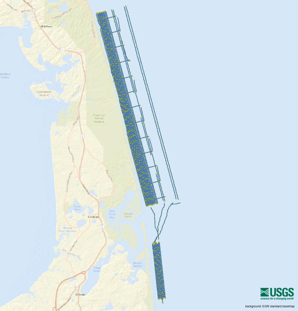
Entity_Type_Label: 2021-004-FA_T20P_Tracklines.shp
Entity_Type_Definition:
Shapefile of T20P multibeam echo sounder tracklines collected from outer Cape Cod, Massachusetts during USGS Field Activity 2021-004-FA.
Entity_Type_Definition_Source: U.S. Geological Survey
Attribute:
Attribute_Label: LineName
Attribute_Definition:
Hysweep HSX filename for the T20-P MBES trackline in the format: UTC Julian date and time (DDD_NNNN_HHMM format, i.e. '167_0030_1410', where DDD is the Julian date of the start of the line, NNNN is an optional planning number (typically 0000) and HHMM is hour minute in UTC time). In a few cases, a line restart resulted in a LineName where an additional _0001 was appended to the filename (for example '166_0000_1734_0001').
Attribute_Definition_Source: U.S. Geological Survey
Attribute_Domain_Values:
Unrepresentable_Domain: Character set
Attribute:
Attribute_Label: Year_JD
Attribute_Definition:
Year and Julian day at the start of the survey line in the format: YYYY-JD; where Julian day is the integer number (although recorded here in text string format) representing the interval of time in days since January 1 of the year of collection.
Attribute_Definition_Source: U.S. Geological Survey
Attribute_Domain_Values:
Unrepresentable_Domain: Character set
Attribute:
Attribute_Label: StartTime
Attribute_Definition:
Calendar date and UTC time at the start of the survey line in the format: YYYY-MM-DD HH:MM:SS.SSS, example "2021-06-20 13:23:50.210".
Attribute_Definition_Source: U.S. Geological Survey
Attribute_Domain_Values:
Unrepresentable_Domain: Character set
Attribute:
Attribute_Label: EndTime
Attribute_Definition:
Calendar date and UTC time at the end of the survey line in the format: YYYY-MM-DD HH:MM:SS.SSS, example "2021-06-20 14:22:54.831".
Attribute_Definition_Source: U.S. Geological Survey
Attribute_Domain_Values:
Unrepresentable_Domain: Character set
Attribute:
Attribute_Label: TotalTime
Attribute_Definition:
Total survey time for a particular trackline. Lines over 60 minutes in duration have the format HH:MM:SS.SSS; lines less than 60 minutes but more than 1 minute in duration have the format MM:SS.SSS (e.g. "59:04.621"), and lines less than 1 minute in duration have the format SS.SSS.
Attribute_Definition_Source: U.S. Geological Survey
Attribute_Domain_Values:
Unrepresentable_Domain: Character set
Attribute:
Attribute_Label: SurveyID
Attribute_Definition:
Woods Hole Coastal and Marine Science Center (WHCMSC) field activity identifier (e.g. "2021-004-FA" where 2021 is the survey year, 004 is survey number of that year, and FA is Field Activity).
Attribute_Definition_Source: U.S. Geological Survey
Attribute_Domain_Values:
Unrepresentable_Domain: Character set
Attribute:
Attribute_Label: VehicleID
Attribute_Definition: Survey vessel name.
Attribute_Definition_Source: U.S. Geological Survey
Attribute_Domain_Values:
Unrepresentable_Domain: Character set
Attribute:
Attribute_Label: DeviceID
Attribute_Definition: Sonar device used to collect MBES data.
Attribute_Definition_Source: U.S. Geological Survey
Attribute_Domain_Values:
Unrepresentable_Domain: Character set
Attribute:
Attribute_Label: Length_km
Attribute_Definition:
Length of T20P trackline in kilometers (UTM Zone 19N, WGS 84) calculated in CARIS.
Attribute_Definition_Source: U.S. Geological Survey
Attribute_Domain_Values:
Range_Domain:
Range_Domain_Minimum: 0.006
Range_Domain_Maximum: 12.166
Attribute_Units_of_Measure: kilometers
Attribute_Measurement_Resolution: 0.001
Distribution_Information:
Distributor:
Contact_Information:
Contact_Organization_Primary:
Contact_Organization: U.S. Geological Survey
Contact_Person: Coastal and Marine Hazards and Resources Program
Contact_Position: Geologist
Contact_Address:
Address_Type: mailing and physical address
Address: 384 Woods Hole Rd.
City: Woods Hole
State_or_Province: MA
Postal_Code: 02543-1598
Country: USA
Contact_Voice_Telephone: 508-548-8700 x2315
Contact_Facsimile_Telephone: 508-457-2310
Contact_Electronic_Mail_Address: whsc_data_contact@usgs.gov
Resource_Description:
Multibeam echo sounder, Teledyne SeaBat T-20P tracklines, collected from outer Cape Cod, Massachusetts during USGS Field Activity 2021-004-FA: includes the shapefile 2021-004-FA_T20P_Tracklines.shp, the browse graphic 2021-004-FA_T20P_Tracklines_browse.jpg, and the Federal Geographic Data Committee (FGDC) Content Standards for Digital Geospatial Metadata (CSDGM) metadata file 2021-004-FA_T20P_Tracklines_meta.xml.
Distribution_Liability:
Unless otherwise stated, all data, metadata and related materials are considered to satisfy the quality standards relative to the purpose for which the data were collected. Although these data and associated metadata have been reviewed for accuracy and completeness and approved for release by the U.S. Geological Survey (USGS), no warranty expressed or implied is made regarding the display or utility of the data for other purposes, nor on all computer systems, nor shall the act of distribution constitute any such warranty.
Standard_Order_Process:
Digital_Form:
Digital_Transfer_Information:
Format_Name: Shapefile
Format_Version_Number: QGIS (version 3.28)
Format_Specification: Shapefile
Format_Information_Content:
Shapefile of MBES tracklines collected from outer Cape Cod, Massachusetts during USGS Field Activity 2021-004-FA and the associated metadata.
File_Decompression_Technique: Use any zip decompression utility
Transfer_Size: 0.4
Digital_Transfer_Option:
Online_Option:
Computer_Contact_Information: Access_Instructions:
The data can be downloaded using the Network Resource Name links. The first link is a direct link to download the zipped file of data. The second and third links are to a landing page for the entire data release where the data, metadata, and browse graphic can be downloaded.
Fees: none
Technical_Prerequisites:
To utilize these data, the user must have software capable of reading shapefile format, or GIS software.
Metadata_Reference_Information:
Metadata_Date: 20231114
Metadata_Contact:
Contact_Information:
Contact_Person_Primary:
Contact_Person: Seth Ackerman
Contact_Organization: U.S. Geological Survey
Contact_Position: Geologist
Contact_Address:
Address_Type: mailing and physical address
Address: 384 Woods Hole Rd.
City: Woods Hole
State_or_Province: MA
Postal_Code: 02543-1598
Country: USA
Contact_Voice_Telephone: 508-548-8700 x2315
Contact_Facsimile_Telephone: 508-457-2310
Contact_Electronic_Mail_Address: whsc_data_contact@usgs.gov
Metadata_Standard_Name: Content Standards for Digital Geospatial Metadata
Metadata_Standard_Version: FGDC-STD-001-1998
Metadata_Time_Convention: local time

This page is <https://cmgds.marine.usgs.gov/catalog/whcmsc/DRB_data_release/DRB_P9GO90TI/2021-004-FA_T20P_Tracklines_meta.html>
Generated by mp version 2.9.51 on Wed Nov 15 10:11:10 2023