1-meter per pixel sidescan-sonar mosaic collected in Moultonborough Bay, Lake Winnipesaukee, New Hampshire by the U.S. Geological Survey in 2005 (GeoTIFF, UTM Zone 19N, WGS 84, WINNI_SONAR.TIF)

Metadata also available as - [Questions & Answers] - [Parseable text] - [XML]

Metadata:

Identification_Information:
Citation:
Citation_Information:
Originator: U.S. Geological Survey
Publication_Date: 2014
Title:
1-meter per pixel sidescan-sonar mosaic collected in Moultonborough Bay, Lake Winnipesaukee, New Hampshire by the U.S. Geological Survey in 2005 (GeoTIFF, UTM Zone 19N, WGS 84, WINNI_SONAR.TIF)
Edition: 1.0
Geospatial_Data_Presentation_Form: remote-sensing image
Series_Information:
Series_Name: data release
Issue_Identification: DOI:10.5066/F71N7Z4H
Publication_Information:
Publication_Place:
Woods Hole Coastal and Marine Science Center, Woods Hole, Massachusetts
Publisher: U.S. Geological Survey, Coastal and Marine Geology Program
Online_Linkage: https://doi.org/10.5066/F71N7Z4H
Online_Linkage: Online_Linkage: Larger_Work_Citation:
Citation_Information:
Originator: Denny, J.F.
Originator: Danforth, W.W.
Originator: Worley, C.R.
Originator: Irwin, B.J.
Publication_Date: 2014
Title:
High-resolution geophysical and sample data collected in Moultonborough Bay, Lake Winnipesaukee, New Hampshire in 2005, USGS Field Activity 2005-004-FA
Edition: 1.0
Series_Information:
Series_Name: data release
Issue_Identification: DOI:10.5066/F71N7Z4H
Publication_Information:
Publication_Place: Reston, VA
Publisher: U.S. Geological Survey
Online_Linkage: https://doi.org/10.5066/F71N7Z4H
Description:
Abstract:
In freshwater bodies of New Hampshire, the most problematic aquatic invasive plant species is Myriophyllum heterophyllum or variable leaf water-milfoil. Once established, variable leaf water-milfoil forms dense beds that can alter the limnologic characteristics of a waterbody, impacting natural lacustrine communities and their habitats. Variable leaf water-milfoil infestations also disrupt recreational uses of waterbodies and have negatively affected swimming, boating, fishing, and property values in and around several lakes and ponds in New Hampshire.
In 1965, Moultonborough Bay, Lake Winnipesaukee became the first waterbody in New Hampshire where variable leaf water-milfoil was observed. Variable leaf water-milfoil is native to the Southeastern and Midwestern areas of the United States where more alkaline waters appear to limit the growth of this plant. Outside its native range, however, it adapts well to the relatively acidic, low-alkalinity, and nutrient-poor conditions of oligotrophic lakes and bays similar to Moultonborough Bay.
In 2005, the New Hampshire Department of Environmental Services (NHDES) collaborated with the U.S. Geological Survey to investigate the distribution (presence and density) of variable leaf water-milfoil in Moultonborough Bay. This study utilized geophysical systems and conventional water-quality measurements to identify lake-floor environments that may provide suitable habitat for the establishment and growth of variable leaf water-milfoil. The results of the study are intended to assist resource managers in federal and state agencies by providing methods for detecting variable leaf water-milfoil and for identifying areas susceptible to infestation. Ultimately, this information may lead to early detection, prevention, and more effective mitigation strategies.
Field activity information for this cruise is available on-line through the U.S. Geological Survey Coastal and Marine Geoscience Data System https://cmgds.marine.usgs.gov/fan_info.php?fa=2005-004-FA.
Purpose:
This sonar mosaic was generated from Klein 3000 sidescan-sonar data collected by the U.S. Geological Survey during USGS field activity 2005-004-FA within Moultonborough Bay, Lake Winnipesaukee, New Hampshire. These data are used to define the lake floor sediment distribution within Moultonborough Bay. The sonar data will be correlated to sediment samples, bottom video and photographs collected in the bay in order to interpret the acoustic facies.
Time_Period_of_Content:
Time_Period_Information:
Single_Date/Time:
Calendar_Date: 20050726
Currentness_Reference: ground condition
Status:
Progress: Complete
Maintenance_and_Update_Frequency: None planned
Spatial_Domain:
Bounding_Coordinates:
West_Bounding_Coordinate: -71.395192
East_Bounding_Coordinate: -71.353088
North_Bounding_Coordinate: 43.731992
South_Bounding_Coordinate: 43.701454
Keywords:
Theme:
Theme_Keyword_Thesaurus: USGS Metadata Identifier
Theme_Keyword: USGS:429c02d5-4c0b-40d3-ac0f-a00ab001c9a1
Theme:
Theme_Keyword_Thesaurus: None
Theme_Keyword: U.S. Geological Survey
Theme_Keyword: USGS
Theme_Keyword: Coastal and Marine Geology Program
Theme_Keyword: CMGP
Theme_Keyword: Woods Hole Coastal and Marine Science Center
Theme_Keyword: WHCMSC
Theme_Keyword: Marine Geology
Theme_Keyword: field activity number 2005-004-FA
Theme_Keyword: USGS CMGP InfoBank ID R-1-05-NH
Theme_Keyword: sidescan
Theme_Keyword: sidescan-sonar
Theme_Keyword: sonar
Theme_Keyword: backscatter
Theme_Keyword: GeoTIFF Image
Theme_Keyword: gray scale
Theme_Keyword: mosaic
Theme_Keyword: Klein
Theme_Keyword: Klein 3000
Theme_Keyword: k3k
Theme_Keyword: R/V Rafael
Theme:
Theme_Keyword_Thesaurus: ISO 19115 Topic Category
Theme_Keyword: inlandWaters
Theme_Keyword: imageryBaseMapsEarthCover
Theme_Keyword: geoscientificInformation
Theme:
Theme_Keyword_Thesaurus: USGS Thesaurus
Theme_Keyword: lakebed acoustic reflectivity
Theme_Keyword: image mosaics
Theme_Keyword: sidescan sonar
Theme_Keyword: geophysics
Theme_Keyword: geospatial datasets
Place:
Place_Keyword_Thesaurus: None
Place_Keyword: North America
Place_Keyword: United States
Place_Keyword: New Hampshire
Place_Keyword: Lake Winnipesaukee
Place_Keyword: Moultonborough Bay
Access_Constraints: none
Use_Constraints:
Public domain data from the U.S. Government are freely redistributable with proper metadata and source attribution. Please recognize the U.S. Geological Survey as the originator of the dataset.
Point_of_Contact:
Contact_Information:
Contact_Person_Primary:
Contact_Person: Jane F. Denny
Contact_Organization: U.S. Geological Survey
Contact_Position: Geologist
Contact_Address:
Address_Type: mailing and physical address
Address: 384 Woods Hole Road
City: Woods Hole
State_or_Province: Massachusetts
Postal_Code: 02543
Country: USA
Contact_Voice_Telephone: 508-548-8700 x 2311
Contact_Facsimile_Telephone: 508-457-2310
Contact_Electronic_Mail_Address: jdenny@usgs.gov
Browse_Graphic:
Browse_Graphic_File_Name: Browse_Graphic_File_Description:
Grey scale image of sidescan-sonar mosaic for Moultonborough Bay, Lake Winnipesaukee
Browse_Graphic_File_Type: JPEG
Native_Data_Set_Environment:
Microsoft Windows Vista Version 6.1 (Build 7601) Service Pack 1; ESRI ArcCatalog 9.3.1.4095
Cross_Reference:
Citation_Information:
Originator: Denise M. Argue
Originator: Richard G. Kiah
Originator: Jane F. Denny
Originator: Jeffrey R. Deacon
Originator: William W. Danforth
Originator: Craig M. Johnston
Originator: Amy P. Smagula
Publication_Date: 2007
Title:
Relation of Lake-Floor Characteristics to the Distribution of Variable Leaf Water-Milfoil in Moultonborough Bay, Lake Winnipesaukee, New Hampshire, 2005
Edition: 1.0
Geospatial_Data_Presentation_Form: document
Series_Information:
Series_Name: Scientific Investigations Report
Issue_Identification: 2007-5125
Publication_Information:
Publication_Place: Reston, Virginia
Publisher: U.S. Geological Survey
Online_Linkage: https://pubs.usgs.gov/sir/2007/5125/
Cross_Reference:
Citation_Information:
Originator: William W. Danforth
Publication_Date: 1997
Title:
XSonar/ShowImage: A complete system for rapid sidescan-sonar processing and display.
Edition: 1.0
Geospatial_Data_Presentation_Form: document
Series_Information:
Series_Name: Open-File Report
Issue_Identification: 97-686
Publication_Information:
Publication_Place: Reston, VA
Publisher: U.S. Geological Survey
Online_Linkage: https://pubs.er.usgs.gov/publication/ofr97686
Cross_Reference:
Citation_Information:
Originator: Valerie Paskevich
Publication_Date: 1996
Title:
MAPIT: An improved method for mapping digital sidescan sonar data using the Woods Hole Image Processing System (WHIPS) Software
Edition: 1.0
Geospatial_Data_Presentation_Form: document
Series_Information:
Series_Name: Open-File Report
Issue_Identification: 96-281
Publication_Information:
Publication_Place: Reston, VA
Publisher: U.S. Geological Survey
Online_Linkage: https://pubs.er.usgs.gov/publication/ofr96281
Data_Quality_Information:
Attribute_Accuracy:
Attribute_Accuracy_Report:
Image pixel values contain acoustic reflectivity values normalized to an 8-bit data range (0-254). Low-backscatter is represented by dark tones (low values) and high-backscatter is represented by bright tones (high values). The nodata value is 255.
Logical_Consistency_Report:
This image represents sidescan-sonar backscatter data collected within Moultonborough Bay, Lake Winnipesaukee, New Hampshire. Gaps generally occur in nearshore areas too shallow to successfully maneuver the R/V Rafael.
Completeness_Report:
Lines 43 - 112 were used to generate the final GeoTIFF mosaic. Gaps present in this data are generally in shallow-water areas where the system was not tracking bottom, or poor quality sonar returns precluded use in the completed mosaic. Additionally, some lines were very noisy (e.g. l110f1) and were not included in the final mosaic.
Positional_Accuracy:
Horizontal_Positional_Accuracy:
Horizontal_Positional_Accuracy_Report:
Navigation was acquired with Wide Area Augmentation System ( WAAS), which is accurate to + or - 1 to 2 meters, horizontally. Navigation data were acquired with a LGBX Pro receiver and sent directly to the sidescan-sonar acquisition software, L3-Klein Associates, SonarPro. The LGBX Pro received WAAS positions from an antenna located on the port, aft roof of the cabin. The sidescan-sonar towfish was towed at a shallow depth, close to the lake surface due to the shallow waters of the survey area. Layback was measured upon deployment of the towfish. During data processing, layback was found to be negligible due to the shallow-tow of the vehicle. No significant offset of features was observed when mosaicking adjacent lines of sonar data. The following offsets are measured prior to deployment of the sidescan-sonar towfish and entered into SonarPro: height of the block, offset from DGPS (WAAS) antenna to the block, and height of the DGPS antenna above the waterline. Considering errors in measuring towfish layback, as well as accuracy of WAAS, horizontal accuracy of the sidescan-sonar data are conservatively assumed to be + or - 10 meters.
Lineage:
Source_Information:
Source_Citation:
Citation_Information:
Originator: U.S. Geological Survey
Publication_Date: Unpublished Material
Title: raw backscatter data
Type_of_Source_Media: disc
Source_Time_Period_of_Content:
Time_Period_Information:
Single_Date/Time:
Calendar_Date: 20050726
Source_Currentness_Reference: ground condition of field activity
Source_Citation_Abbreviation: none
Source_Contribution:
Data were acquired with an L3-Klein Associates 3000 digital, dual-frequency, sidescan-sonar (www.l-3klein.com). Dual frequencies are nominally 100 (132 kHz) and 500 (445 kHz) kHz. The sidescan-sonar was towed aft the R/V Rafael. Line spacing was 50-meters throughout the survey area. Data files were recorded with SonarPro (2005) in XTF (extended-Triton Format) format at a 0.03-sec ping rate yielding a 50-meter range (100-meter swath). The 100 kHz data were used to generate the sidescan-sonar mosaic. The data range within the sidescan-sonar mosaic (digital number values (DN) of the 8-bit image) is 0 - 254, with the background value (i.e. No DATA) set to 255.
Process_Step:
Process_Description:
XSonar/ShowImage sidescan-sonar processing software was used to process the raw XTF sonar data following the methodology of Danforth, (1997). A 4 across track x 3 along track pixel median filter was applied to the raw sidescan-sonar data to remove speckle noise and a normalization of 4095 was applied to adjust the dynamic range within the output processed file. Processed data are stored as 8-bit. Navigation were also extracted from the raw data at 2-minute intervals and saved in an ASCII file. Quality checks were conducted on the navigation to eliminate spurious or duplicate navigation fixes. The sonar data were further processed to correct for towfish altitude (i.e. proper tracking of the lakefloor), and slant-range and beam pattern distortions inherent in the sonar data. Processed sonar files were then merged with the edited navigation. Processed sonar files were then mapped at a 1-meter resolution in UTM coordinates (UTM, Zone 19N, WGS 84, meters) and saved in two XSonar/ShowImage mosaic files representing odd and even (i.e. every other line) sonar tracklines, or files.
Below are the typical parameters for processing with XSonar: File Type: XTF, Low Frequency (132 kHz)
Setup Option: Navigation= Lat/Lon, Navigation Interval= 2 minute
Demultiplexing Range and Filter options: Across track=4 (pixels), Along track= 3 (pixels), Port/Starboard Normalize = 4095 (default), Port High Pass: 65535 (default,) Input= 16 bit, Normalize Image= yes.
Beam Pattern Correction options: Number of lines= 100, Ping overlap=50, Max beam angle= 90 (default), Response angle=55 (default), Data normalization (0-255)=1 (default), Port/Stbd Tone Adjustment= "on" and "Normal"
Jane F. Denny performed this and all subsequent process steps.
Process_Date: 2005
Process_Contact:
Contact_Information:
Contact_Person_Primary:
Contact_Person: Jane F. Denny
Contact_Organization: U.S. Geological Survey
Contact_Position: Geologist
Contact_Address:
Address_Type: mailing and physical address
Address: 384 Woods Hole Road
City: Woods Hole
State_or_Province: Massachusetts
Postal_Code: 02536
Country: USA
Contact_Voice_Telephone: 508-548-8700 x2311
Contact_Facsimile_Telephone: 508-57-2310
Contact_Electronic_Mail_Address: jdenny@usgs.gov
Process_Step:
Process_Description:
The Unix Portable Bitmap Format (PBM) utilities, rawtopgm and pnmtotiff, were used to extract the 80-byte header from the XSonar/ShowImage odd and even mosaic files and convert the raw raster image to a TIFF image file. (rawtopgm -headership 80 #xpixel #ypixel *.ras | pnmtotiff - > *.tif)
Process_Date: 2005
Process_Step:
Process_Description:
The odd and even TIFF images were then imported into PCI Geomatica Software and digitally mosaicked at a 1-meter pixel resolution using PCI's OrthoEngine based on the procedures described in Paskevich (1996). The composite mosaic was registered in the UTM (Zone 19N, WGS84, meters) coordinate system and exported as a GeoTIFF image.
A TIFF World File (TFW) was created using Mentor Software GeoTiffExamine (no version) to define the spatial extent of the TIFF image. GeoTiffExamine was also used to transfer the spatial information to the TIFF, creating a GeoTIFF image
Process_Date: 2005
Process_Step:
Process_Description:
The GeoTIFF image was then imported to Adobe Photoshop CS3 in order to adjust the 8-bit range of the image file, so that areas of no data (i.e. the background) are represented by a pixel value of 255 and areas of data range from pixel values of 0 to 254.
Process_Date: 2013
Process_Step:
Process_Description:
After editing the data range and saving the TIFF image, the header information was not saved. A world file (tfw) was created with a text editor. GeoTiffExamine was used to generate a GeoTIFF from the world file (tfw).
Process_Date: 2013
Process_Step:
Process_Description:
The online links to the data were updated to reflect the new server hosting the data. Additionally, other small edits could be made to the metadata, such as modifying http to https where appropriate. The metadata date (but not the metadata creator) was edited to reflect the date of these changes.
Process_Date: 20170406
Process_Contact:
Contact_Information:
Contact_Organization_Primary:
Contact_Organization: U.S. Geological Survey
Contact_Person: VeeAnn A. Cross
Contact_Position: Marine Geologist
Contact_Address:
Address_Type: Mailing and Physical
Address: 384 Woods Hole Road
City: Woods Hole
State_or_Province: MA
Postal_Code: 02543-1598
Contact_Voice_Telephone: 508-548-8700 x2251
Contact_Facsimile_Telephone: 508-457-2310
Contact_Electronic_Mail_Address: vatnipp@usgs.gov
Process_Step:
Process_Description: USGS Thesaurus keywords added to the keyword section.
Process_Date: 20180720
Process_Contact:
Contact_Information:
Contact_Organization_Primary:
Contact_Organization: U.S. Geological Survey
Contact_Person: VeeAnn A. Cross
Contact_Position: Marine Geologist
Contact_Address:
Address_Type: Mailing and Physical
Address: 384 Woods Hole Road
City: Woods Hole
State_or_Province: MA
Postal_Code: 02543-1598
Contact_Voice_Telephone: 508-548-8700 x2251
Contact_Facsimile_Telephone: 508-457-2310
Contact_Electronic_Mail_Address: vatnipp@usgs.gov
Process_Step:
Process_Description:
Added keywords section with USGS persistent identifier as theme keyword.
Process_Date: 20200908
Process_Contact:
Contact_Information:
Contact_Organization_Primary:
Contact_Organization: U.S. Geological Survey
Contact_Person: VeeAnn A. Cross
Contact_Position: Marine Geologist
Contact_Address:
Address_Type: Mailing and Physical
Address: 384 Woods Hole Road
City: Woods Hole
State_or_Province: MA
Postal_Code: 02543-1598
Contact_Voice_Telephone: 508-548-8700 x2251
Contact_Facsimile_Telephone: 508-457-2310
Contact_Electronic_Mail_Address: vatnipp@usgs.gov
Spatial_Data_Organization_Information:
Direct_Spatial_Reference_Method: Raster
Raster_Object_Information:
Raster_Object_Type: Pixel
Row_Count: 3300
Column_Count: 3300
Vertical_Count: 1
Spatial_Reference_Information:
Horizontal_Coordinate_System_Definition:
Planar:
Grid_Coordinate_System:
Grid_Coordinate_System_Name: Universal Transverse Mercator
Universal_Transverse_Mercator:
UTM_Zone_Number: 19
Transverse_Mercator:
Scale_Factor_at_Central_Meridian: 0.999600
Longitude_of_Central_Meridian: -69.000000
Latitude_of_Projection_Origin: 0.000000
False_Easting: 500000.000000
False_Northing: 0.000000
Planar_Coordinate_Information:
Planar_Coordinate_Encoding_Method: row and column
Coordinate_Representation:
Abscissa_Resolution: 1.000000
Ordinate_Resolution: 1.000000
Planar_Distance_Units: meters
Geodetic_Model:
Horizontal_Datum_Name: D_WGS_1984
Ellipsoid_Name: WGS_1984
Semi-major_Axis: 6378137.000000
Denominator_of_Flattening_Ratio: 298.257224
Entity_and_Attribute_Information:
Overview_Description:
Entity_and_Attribute_Overview:
There are no attributes associated with a GeoTIFF image. Image pixel values contain acoustic reflectivity values normalized to an 8-bit data range (0-255) with the data range 0-254. Low-backscatter is represented by dark tones (low values) and high-backscatter is represented by bright tones (high values). The background color is set to 255 and can be turned off without removing data values.
Entity_and_Attribute_Detail_Citation: U.S. Geological Survey
Distribution_Information:
Distributor:
Contact_Information:
Contact_Person_Primary:
Contact_Person: Jane F. Denny
Contact_Organization: U.S. Geological Survey
Contact_Position: Geologist
Contact_Address:
Address_Type: mailing and physical address
Address: 384 Woods Hole Road
City: Woods Hole
State_or_Province: Massachusetts
Postal_Code: 02543
Country: USA
Contact_Voice_Telephone: 508-548-8700 x2311
Contact_Facsimile_Telephone: 508-457-2310
Contact_Electronic_Mail_Address: jdenny@usgs.gov
Resource_Description:
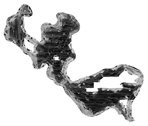
The winni_sonar.zip file contains the GeoTIFF image winni_sonar.tif and the associated TIFF world file winni_sonar.tfw. In addition to the image and world file, the zip file also contains the browse graphic (winni_sonarsm.jpg) and the FGDC CSDGM metadata in the following formats: XML, HTML, FAQ and text.
Distribution_Liability:
Neither the U.S. Government, the Department of the Interior, nor the USGS, nor any of their employees, contractors, or subcontractors, make any warranty, express or implied, nor assume any legal liability or responsibility for the accuracy, completeness, or usefulness of any information, apparatus, product, or process disclosed, nor represent that its use would not infringe on privately owned rights. The act of distribution shall not constitute any such warranty, and no responsibility is assumed by the U.S. Geological Survey in the use of these data or related materials. Any use of trade, product, or firm names is for descriptive purposes only and does not imply endorsement by the U.S. Government.
Standard_Order_Process:
Digital_Form:
Digital_Transfer_Information:
Format_Name: GeoTIFF
Format_Version_Number: 1.0
Format_Specification: GeoTIFF Format (Georeferenced TIFF Image)
Format_Information_Content:
This zip file contains a geographic GeoTIFF image of sidescan-sonar data from the Moultonborough Bay survey area. This also includes a TIFF World File (tfw) and associated metadata.
File_Decompression_Technique: Use WinZip, 7zip, Peazip or pkUnzip
Transfer_Size: 1.5
Digital_Transfer_Option:
Online_Option:
Computer_Contact_Information: Access_Instructions: Data can be downloaded via the Internet
Fees: none
Technical_Prerequisites:
This zip file contains a GeoTIFF image with an accompanying world file. To utilize these data, the user must have an image viewer, image processing or GIS software package capable of importing a GeoTIFF image. A free spatial data viewer, ArcGIS Explorer, capable of displaying the data is available from Esri at www.esri.com. The zip file also contains associated metadata.
Metadata_Reference_Information:
Metadata_Date: 20200908
Metadata_Contact:
Contact_Information:
Contact_Person_Primary:
Contact_Person: Jane F. Denny
Contact_Organization: U.S. Geological Survey
Contact_Position: Geologist
Contact_Address:
Address_Type: mailing and physical address
Address: 384 Woods Hole Road
City: Woods Hole
State_or_Province: Massachusetts
Postal_Code: 02543
Country: USA
Contact_Voice_Telephone: 508-548-8700 x2311
Contact_Facsimile_Telephone: 508-457-2310
Contact_Electronic_Mail_Address: jdenny@usgs.gov
Metadata_Standard_Name: FGDC Content Standards for Digital Geospatial Metadata
Metadata_Standard_Version: FGDC-STD-001-1998
Metadata_Time_Convention: local time

This page is <https://cmgds.marine.usgs.gov/catalog/whcmsc/field_activities/2005_004_fa/winni_sonarmeta.html>
Generated by mp version 2.9.50 on Tue Sep 21 18:20:14 2021