Citation:
Citation_Information:
Originator: U.S. Geological Survey
Publication_Date: 20220131
Title:
Bathymetric data during field activity 2021-014-FA offshore Head of the Meadow Beach, Truro MA on February 11, 2021
Edition: 1.0
Geospatial_Data_Presentation_Form: raster digital data
Series_Information:
Series_Name: data release
Issue_Identification: DOI:10.5066/P9D94NZ3
Publication_Information:
Publication_Place: Woods Hole Coastal and Marine Science Center, Woods Hole, MA
Publisher:
U.S. Geological Survey, Coastal and Marine Hazards and Resources Program
Online_Linkage: https://doi.org/10.5066/P9D94NZ3
Online_Linkage:
Larger_Work_Citation:
Citation_Information:
Originator: J. Over
Originator: C. Sherwood
Originator: P. Traykovski
Publication_Date: 2022
Title:
Topographic and bathymetric data, structure from motion imagery, and ground control data collected at Head of the Meadow, Truro in February 2021, U.S. Geological Survey Field Activity 2021-014-FA
Edition: 1.0
Geospatial_Data_Presentation_Form: tabular digital data
Series_Information:
Series_Name: data release
Issue_Identification: DOI:10.5066/P9D94NZ3
Publication_Information:
Publication_Place: Reston, VA
Publisher: U.S. Geological Survey
Other_Citation_Details:
Over, J.R., Sherwood, C.R., and Traykovski, P.A., 2022, Topographic and bathymetric data, structure from motion imagery, and ground control data collected at Head of the Meadow, Truro in February 2021, U.S. Geological Survey Field Activity 2021-014-FA: U.S. Geological Survey data release,
https://doi.org/10.5066/P9D94NZ3
Description:
Abstract:
These data map the beach and nearshore environment at Head of the Meadow Beach in Truro, MA, providing updated regional context for the 2019 CoastCam installation. CoastCam CACO-01 are two video cameras aimed at the beach that view the coast shared by beachgoers, shorebirds, seals, and sharks. These data were collected as part of field activity 2021-014-FA and a collaboration with the National Park Service at Cape Cod National Seashore to monitor the region. In February 2021, U.S. Geological Survey and Woods Hole Oceanographic Institute (WHOI) scientists conducted field surveys to re-map the field of view of the CoastCam. Aerial images of the beach for use in structure from motion were taken with a camera (Ricoh GRII) and a post-processed kinematic (PPK) system attached to a helium powered balloon-kite (Helikite). High-precision GPS targets (AeroPoints) were used as ground control points. Bathymetry was collected in the nearshore using a single-beam echosounder mounted on a surf capable self-righting electric autonomous Small Surf Vehicle (SSV). Agisoft Metashape (v. 1.7.2) was used to create a digital elevation model with the collected imagery and this was merged with the bathymetry in MATLAB (v. 2020) to create a continuous topobathy product.
Purpose:
These data may be used as a high-resolution bathymetry dataset of Head of the Meadow Beach by the public, researchers, and others to observe ground conditions and change over time.
Supplemental_Information:
This bathymetric grid, as constructed using the raw echosounder and GPS data available in the 2021014FA_Bathyemtry.zip file, represents the nearshore of Head of the Meadow Beach in view of CoastCam CACO-01 cameras on February 11, 2021. The grid has sections of interpolation and has not been cloud optimized. For more information about the WHCMSC Field Activity, see
https://cmgds.marine.usgs.gov/fan_info.php?fan=2021-014-FA.
Time_Period_of_Content:
Time_Period_Information:
Single_Date/Time:
Calendar_Date: 20210211
Currentness_Reference:
ground condition; bathymetry was collected on a single day: February 11, 2021
Status:
Progress: Complete
Maintenance_and_Update_Frequency: Not planned
Spatial_Domain:
Bounding_Coordinates:
West_Bounding_Coordinate: -70.07988662
East_Bounding_Coordinate: -70.07068035
North_Bounding_Coordinate: 42.05852660
South_Bounding_Coordinate: 42.05133652
Keywords:
Theme:
Theme_Keyword_Thesaurus: USGS Metadata Identifier
Theme_Keyword: USGS:9979189e-dda6-48ad-a4b8-6568cb6fb6b0
Theme:
Theme_Keyword_Thesaurus: None
Theme_Keyword: U.S. Geological Survey
Theme_Keyword: USGS
Theme_Keyword: Coastal and Marine Hazards and Resources Program
Theme_Keyword: CMHRP
Theme_Keyword: Woods Hole Coastal and Marine Science Center
Theme_Keyword: WHCMSC
Theme:
Theme_Keyword_Thesaurus: USGS Thesaurus
Theme_Keyword: remote sensing
Theme_Keyword: single-beam echo sounder
Theme_Keyword: bathymetry
Theme:
Theme_Keyword_Thesaurus: ISO 19115 Topic Category
Theme_Keyword: geoscientificInformation
Theme_Keyword: oceans
Theme_Keyword: elevation
Place:
Place_Keyword_Thesaurus: Common geographic areas
Place_Keyword: United States
Place_Keyword: Truro
Place_Keyword: Massachusetts
Place_Keyword: Cape Cod
Access_Constraints: None
Use_Constraints:
Public domain data from the U.S. Government are freely redistributable with proper metadata and source attribution. Although these data have been processed successfully on a computer system at the U.S. Geological Survey (USGS), no warranty expressed or implied is made regarding the display or utility of the data for other purposes, nor on all computer systems, nor shall the act of distribution constitute any such warranty. The USGS or the U.S. Government shall not be held liable for improper or incorrect use of the data described and/or contained herein. Not for navigational use. Please recognize the U.S. Geological Survey (USGS) as the source of this information.
Point_of_Contact:
Contact_Information:
Contact_Person_Primary:
Contact_Person: Jin-Si Over
Contact_Organization: U.S. Geological Survey
Contact_Address:
Address_Type: mailing and physical address
Address: U.S. Geological Survey 384 Woods Hole Rd
City: Woods Hole
State_or_Province: MA
Postal_Code: 02543-1598
Contact_Voice_Telephone: 508-548-8700 x2269
Contact_Electronic_Mail_Address: [email protected]
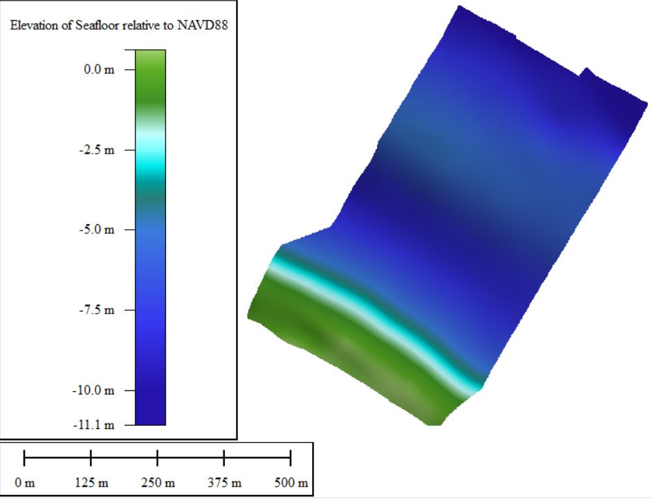
Browse_Graphic:
Browse_Graphic_File_Name:
Browse_Graphic_File_Description:
Height relative to NAVD88-colored image of bathymetry data collected offshore of Head of the Meadow Beach, MA
Browse_Graphic_File_Type: JPEG
Cross_Reference:
Citation_Information:
Originator: Jin-Si R. Over
Originator: Christopher R. Sherwood
Originator: Peter A. Traykovski
Originator: Sandra M. Brosnahan
Originator: Marinna A. Martini
Originator: Eric Marsjanik
Originator: Jonathan S. Borden
Publication_Date: 2021
Title:
Topographic and bathymetric data, sediment samples, and beach imagery collected at Head of the Meadow, Truro in March 2020
Series_Information:
Series_Name: data release
Issue_Identification: DOI:10.5066/P9KSG1RQ
Publication_Information:
Publication_Place: Woods Hole Coastal and Marine Science Center, Woods Hole, MA
Publisher:
U.S. Geological Survey, Coastal and Marine Hazards and Resources Program
Other_Citation_Details:
This publication is the prior years field data at Head of the Meadow Beach.
Online_Linkage: https://doi.org/10.5066/P9KSG1RQ