Citation:
Citation_Information:
Originator: U.S. Geological Survey
Publication_Date: 2021
Title:
Reference marks, ground control points, navigation, and elevation data from pole surveys at Marconi Beach, Wellfleet during field activity 2021-022-FA on January 14 and 15 & March 10 and 17, 2021
Edition: 1.0
Geospatial_Data_Presentation_Form: tabular digital data
Series_Information:
Series_Name: data release
Issue_Identification: DOI:10.5066/P9POZ9VH
Publication_Information:
Publication_Place: Woods Hole Coastal and Marine Science Center, Woods Hole, MA
Publisher:
U.S. Geological Survey, Coastal and Marine Hazards and Resources Program
Online_Linkage: https://doi.org/10.5066/P9POZ9VH
Online_Linkage:
Larger_Work_Citation:
Citation_Information:
Originator: J. Over
Originator: C. Sherwood
Originator: P. Traykovski
Originator: E. Marsjanik
Publication_Date: 2021
Title:
Topographic and bathymetric data, sediment samples, structure from motion imagery, and reference mark data collected at Marconi Beach, Wellfleet in winter 2021, U.S Geological Survey Field Activity 2021-022-FA
Edition: 1.0
Geospatial_Data_Presentation_Form: tabular digital data
Series_Information:
Series_Name: data release
Issue_Identification: DOI:10.5066/P9POZ9VH
Publication_Information:
Publication_Place: Reston, VA
Publisher: U.S. Geological Survey
Other_Citation_Details:
Over, J.R., Sherwood, C.R., Traykovski, P., and E. Marsjanik, 2021, Topographic and bathymetric data, sediment samples, structure from motion imagery, and reference mark data collected at Marconi Beach, Wellfleet in winter 2021, U.S Geological Survey Field Activity 2021-022-FA: U.S Geological Survey data release,
https://doi.org/10.5066/P9POZ9VH
Description:
Abstract:
The data in this publication map the beach and nearshore environment at Marconi Beach in Wellfleet, MA and provide regional context for the 2021 CoastCam installation that looks out at the coast shared by beachgoers, shorebirds, seals, and sharks. These data were collected as part of field activity 2021-022-FA and a collaboration with the National Park Service at Cape Cod National Seashore to monitor the region that falls within the field of view of CoastCam CACO-02, which are two video cameras aimed at the beach. Starting in February and ending in March 2021, U.S Geological Survey and Woods Hole Oceanographic Institute (WHOI) scientists conducted field surveys to collect position and orientation information for the CoastCam cameras and map the field of view. Two new reference marks were established in the Marconi Beach parking area to establish ground control for future surveys. Elevation data were collected using a real time kinematic – satellite navigation system (RTK-GNSS) receiver attached to a pole and walked on the beach. Point data of the beach face were collected along transects. Grain-size analysis was performed on sediment samples collected with a spade along multiple profiles from the bluff base to the intertidal zone. Aerial images of the beach for use in Structure-from-Motion were taken with a camera (Ricoh GRII) and a post-processed kinematic (PPK) system attached to a helium powered balloon-kite (Helikite) and high-precision GPS targets (AeroPoints) were used as ground control points. Bathymetry was collected in the nearshore using a single-beam echosounder mounted on a surf capable self-righting electric autonomous survey vehicle. Agisoft Metashape (v. 1.7.2) was used to create a digital elevation model with the collected imagery and this was merged with the bathymetry in MATLAB (v. 2020) to create a continuous topobathy product.
Purpose:
The reference marks can be used for QA/QC in future surveys and navigation and point data can be used to ground truth and georeference the digital elevation model in the larger work citation.
Supplemental_Information:
Time_Period_of_Content:
Time_Period_Information:
Multiple_Dates/Times:
Single_Date/Time:
Calendar_Date: 20210114
Single_Date/Time:
Calendar_Date: 20210115
Single_Date/Time:
Calendar_Date: 20210310
Single_Date/Time:
Calendar_Date: 20210317
Currentness_Reference:
ground condition; four survey days: reference mark data was collected on January 14 and 15, transect data on March 10, and ground control point data was collected on March 17, 2021.
Status:
Progress: Complete
Maintenance_and_Update_Frequency: Not planned
Spatial_Domain:
Bounding_Coordinates:
West_Bounding_Coordinate: -69.96438619
East_Bounding_Coordinate: -69.96223257
North_Bounding_Coordinate: 41.89469982
South_Bounding_Coordinate: 41.89117591
Keywords:
Theme:
Theme_Keyword_Thesaurus: USGS Metadata Identifier
Theme_Keyword: USGS:89e6cdf4-278e-43d6-aba0-f7182426fb93
Theme:
Theme_Keyword_Thesaurus: None
Theme_Keyword: U.S. Geological Survey
Theme_Keyword: USGS
Theme_Keyword: Coastal and Marine Hazards and Resources Program
Theme_Keyword: CMHRP
Theme_Keyword: Woods Hole Coastal and Marine Science Center
Theme_Keyword: WHCMSC
Theme_Keyword: GPS navigation
Theme:
Theme_Keyword_Thesaurus: USGS Thesaurus
Theme_Keyword: GPS measurement
Theme_Keyword: geolocation measurement
Theme_Keyword: datasets
Theme:
Theme_Keyword_Thesaurus: ISO 19115 Topic Category
Theme_Keyword: geoscientificInformation
Theme_Keyword: oceans
Theme_Keyword: location
Place:
Place_Keyword_Thesaurus: Common geographic areas
Place_Keyword: United States
Place_Keyword: Wellfleet
Place_Keyword: Massachusetts
Place_Keyword: Cape Cod
Access_Constraints: None
Use_Constraints:
Public domain data from the U.S. Government are freely redistributable with proper metadata and source attribution. Although these data have been processed successfully on a computer system at the U.S. Geological Survey (USGS), no warranty expressed or implied is made regarding the display or utility of the data for other purposes, nor on all computer systems, nor shall the act of distribution constitute any such warranty. The USGS or the U.S. Government shall not be held liable for improper or incorrect use of the data described and/or contained herein. Not for navigational use. Please recognize the U.S. Geological Survey (USGS) as the source of this information.
Point_of_Contact:
Contact_Information:
Contact_Person_Primary:
Contact_Person: Jin-Si Over
Contact_Organization: U.S. Geological Survey
Contact_Address:
Address_Type: mailing and physical address
Address: U.S. Geological Survey
City: Woods Hole
State_or_Province: MA
Postal_Code: 02543-1598
Contact_Voice_Telephone: 508-548-8700 x2269
Contact_Electronic_Mail_Address: [email protected]
Browse_Graphic:
Browse_Graphic_File_Name:
Browse_Graphic_File_Description:
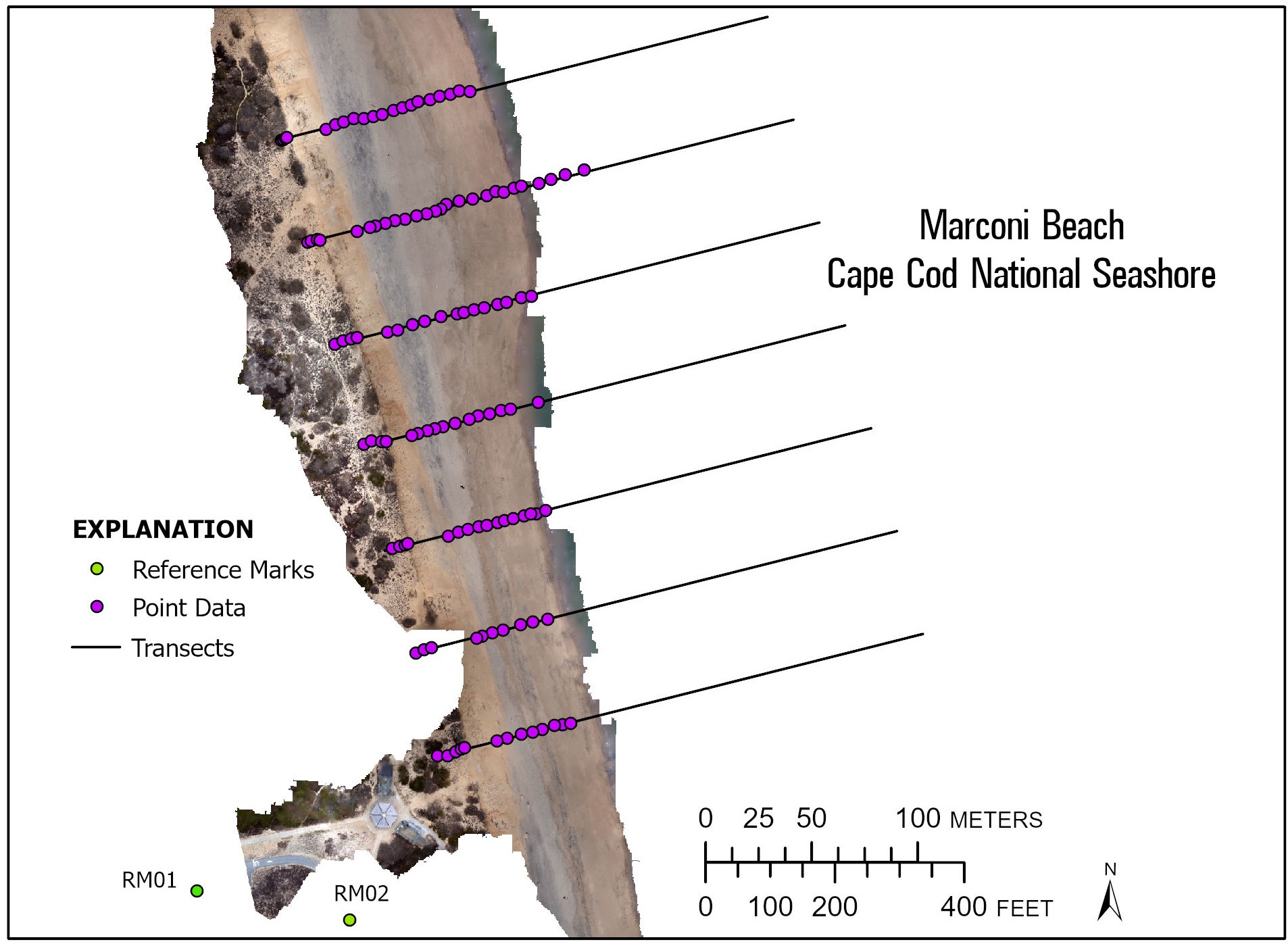
Browse graphic of the spatial distribution of the navigation/elevation points from surveys and ground control deployments at Marconi Beach, MA
Browse_Graphic_File_Type: JPEG
Browse_Graphic:
Browse_Graphic_File_Name:
Browse_Graphic_File_Description:
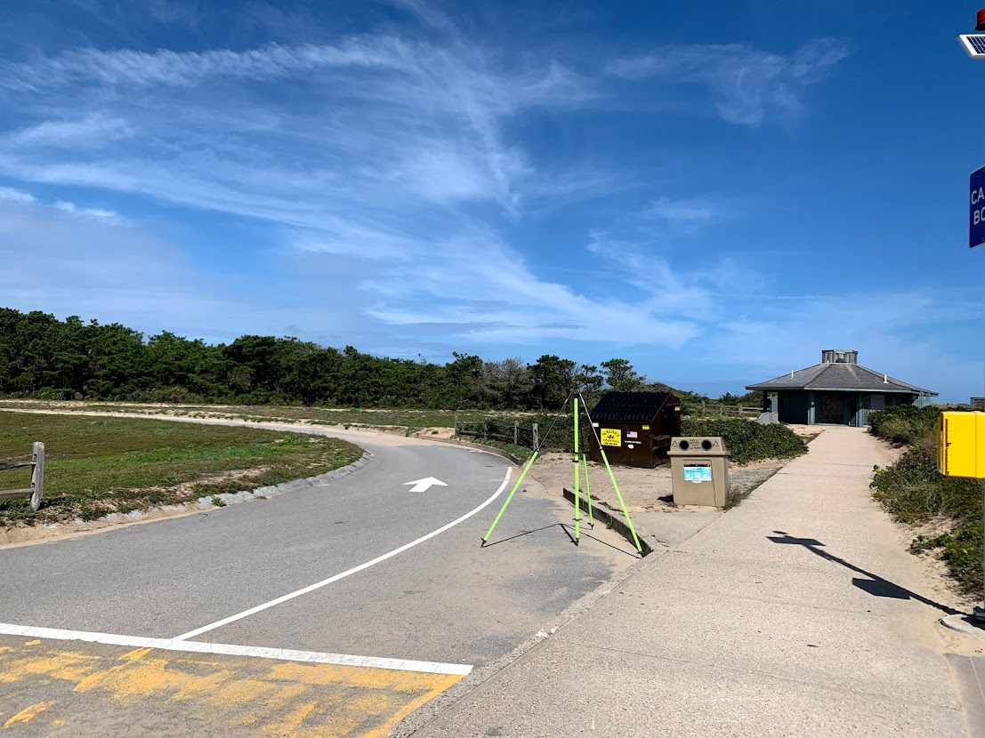
Browse graphic of the location of Reference Mark 01 established in the Marconi Beach parking lot, MA
Browse_Graphic_File_Type: JPEG
Browse_Graphic:
Browse_Graphic_File_Name:
Browse_Graphic_File_Description:
Browse graphic of the location of Reference Mark 02 established at Marconi Beach, MA
Browse_Graphic_File_Type: JPEG