Citation:
Citation_Information:
Originator: Page C. Valentine
Originator: Tammie J. Middleton
Originator: Sarah J. Fuller
Publication_Date: 2001
Title:
Sea floor maps showing topography, sun-illuminated topographic imagery, and backscatter intensity of the Stellwagen Bank National Marine Sanctuary Region off Boston, Massachusetts
Geospatial_Data_Presentation_Form: map
Series_Information:
Series_Name: U.S. Geological Survey Open-File Report
Issue_Identification: 2000-410
Publication_Information:
Publication_Place: Reston, VA
Publisher: U.S. Geological Survey
Online_Linkage: https://doi.org/10.3133/ofr00410
Online_Linkage: http://pubs.usgs.gov/of/2000/of00-410/
Description:
Abstract:
This data set contains the sea floor topographic contours, sun-illuminated topographic imagery, and backscatter intensity generated from a multibeam sonar survey of the Stellwagen Bank National Marine Sanctuary region off Boston, Massachusetts, an area of approximately 1100 square nautical miles. The Stellwagen Bank NMS Mapping Project is designed to provide detailed maps of the Stellwagen Bank region's environments and habitats and the first complete multibeam topographic and sea floor characterization maps of a significant region of the shallow EEZ. Data were collected on four cruises over a two year period from the fall of 1994 to the fall of 1996. The surveys were conducted aboard the Candian Hydrographic Service vessel Frederick G. Creed, a SWATH (Small Waterplane Twin Hull) ship that surveys at speeds of 16 knots. The multibeam data were collected utilizing a Simrad Subsea EM 1000 Multibeam Echo Sounder (95 kHz) that is permanently installed in the hull of the Creed.
Purpose:
Development of a GIS database of sea floor imagery that is accessible to scientists, policymakers, managers, and the general public.
Time_Period_of_Content:
Time_Period_Information:
Range_of_Dates/Times:
Beginning_Date: 19940815
Ending_Date: 19980922
Currentness_Reference:
Multibeam data were collected from the years of 1994 to 1996. Contours and imagery were generated and edited through 1998.
Status:
Progress: Complete
Maintenance_and_Update_Frequency: As needed
Spatial_Domain:
Bounding_Coordinates:
West_Bounding_Coordinate: -70.600
East_Bounding_Coordinate: -70.033
North_Bounding_Coordinate: 42.800
South_Bounding_Coordinate: 42.083
Keywords:
Theme:
Theme_Keyword_Thesaurus: USGS Metadata Identifier
Theme_Keyword: USGS:3238db9b-493b-4475-b258-e0ec0a494dd6
Theme:
Theme_Keyword_Thesaurus: USGS Thesaurus
Theme_Keyword: marine geology
Theme_Keyword: geospatial datasets
Theme_Keyword: bathymetry
Theme_Keyword: sea-floor characteristics
Theme_Keyword: multibeam sonar
Theme:
Theme_Keyword_Thesaurus: none
Theme_Keyword: Geographic Information Systems
Theme_Keyword: GIS
Theme_Keyword: Woods Hole Field Center
Theme_Keyword: WHFC
Theme_Keyword: United States Geological Survey
Theme_Keyword: USGS
Theme_Keyword: SIMRAD SUBSEA EM 1000
Theme_Keyword: Frederick G. CREED
Theme_Keyword: Swath Bathymetry
Theme_Keyword: Multibeam Echo Sounder
Theme_Keyword: Topographic data
Theme_Keyword: Sea floor topography
Theme_Keyword: Bathymetry
Theme_Keyword: Sun-illuminated imagery
Theme_Keyword: Shaded relief imagery
Theme:
Theme_Keyword_Thesaurus: ISO 19115 Topic Category
Theme_Keyword: geoscientificInformation
Place:
Place_Keyword_Thesaurus: none
Place_Keyword: Massachusetts
Place_Keyword: MA
Place_Keyword: Stellwagen Bank National Marine Sanctuary
Place_Keyword: SBNMS
Place_Keyword: Shallow EEZ
Place_Keyword: EEZ
Place_Keyword: Gulf of Maine
Place_Keyword: Atlantic Ocean
Place_Keyword: Ocean
Place:
Place_Keyword_Thesaurus: Augmented FIPS 10-4 and FIPS 6-4
Place_Keyword: OC13 = North Atlantic
Place_Keyword: f25001 = Barnstable
Place_Keyword: f25009 = Essex
Place_Keyword: f25021 = Norfolk
Place_Keyword: f25023 = Plymouth
Access_Constraints: None
Use_Constraints: None.
Point_of_Contact:
Contact_Information:
Contact_Person_Primary:
Contact_Person: Page C Valentine
Contact_Organization: U.S. Geological Survey, ER
Contact_Address:
Address_Type: mailing address
Address: 384 Woods Hole Road
City: Woods Hole
State_or_Province: MA
Postal_Code: 02543-1598
Country: USA
Contact_Voice_Telephone: 508-457-2239
Contact_Facsimile_Telephone: 508-457-2310
Contact_Electronic_Mail_Address: [email protected]
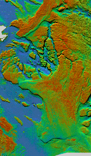
Browse_Graphic:
Browse_Graphic_File_Name: http://pubs.usgs.gov/of/2000/of00-410/images/pseudo2.gif
Browse_Graphic_File_Description:
Reduced-size copy of the backscatter image with topography (color indicates backscatter, shading indicates topography) 351x599 pixels, 32-bit RGB true color, 120 kbytes.
Browse_Graphic_File_Type: GIF
Data_Set_Credit:
U.S. Geological Survey, National Oceanic and Atmospheric Administration, Canadian Hydrographic Service, University of New Brunswick
Native_Data_Set_Environment: OSF1 UNIX, ARC/INFO version 7.0.4
Cross_Reference:
Citation_Information:
Originator: Page C. Valentine
Originator: Tanya S. Unger
Originator: Jessica L. Baker
Publication_Date: 1999
Title:
Backscatter Intensity and Sun-illuminated Sea Floor Topography of the Stellwagen Bank National Marine Sanctuary off Boston, Massachusetts
Edition: 1
Geospatial_Data_Presentation_Form: map
Series_Information:
Series_Name: U.S. Geologial Survey Geologic Investigations Series Map
Issue_Identification: I-2676C
Other_Citation_Details: scale 1:60,000, 1 sheet
Cross_Reference:
Citation_Information:
Originator: Page C. Valentine
Originator: Tanya S. Unger
Originator: Jessica L. Baker
Publication_Date: 1999
Title:
Sea Floor Topography of the Stellwagen Bank National Marine Sanctuary off Boston, Massachusetts
Edition: 1
Geospatial_Data_Presentation_Form: map
Series_Information:
Series_Name: U.S. Geologial Survey Geologic Investigations Series Map
Issue_Identification: I-2676A
Other_Citation_Details: scale 1:60,000, 1 sheet
Cross_Reference:
Citation_Information:
Originator: Page C. Valentine
Originator: Tanya S. Unger
Originator: Jessica L. Baker
Publication_Date: 1999
Title:
Sun-illuminated Sea Floor Topography of the Stellwagen Bank National Marine Sanctuary off Boston, Massachusetts
Edition: 1
Geospatial_Data_Presentation_Form: map
Series_Information:
Series_Name: U.S. Geologial Survey Geologic Investigations Series Map
Issue_Identification: I-2676B
Other_Citation_Details: scale 1:60,000, 1 sheet