USGS - science for a changing world

Pacific Coastal and Marine Science Center

Seafloor Mapping

Home - Images - Products - Data - Publications - Contact


Danger Bay and Phantom Ship, Crater Lake, Oregon

Back to Crater Lake Perspective Views

Download a 300dpi TIFF Image (no annotation) (18mb)

Phantom Ship Image

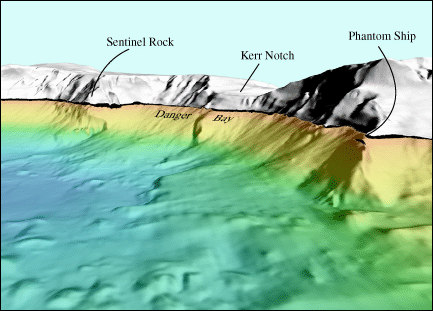
Oblique view of Crater Lake, OR looking east towards Phantom Ship and Danger Bay. The distance across the bottom of the image is approximately 1.2 kilometers (0.7 miles).
 

Accessibility FOIA Privacy Policies and Notices

U.S. Department of the Interior | U.S. Geological Survey
URL: pacmaps/cl-phant.html
Contact Peter Dartnell
Archived in 2018