Home - Images - Products - Data - Publications - Contact
| |
|
|
Shaded Relief - Backscatter - Perspective Views |
|
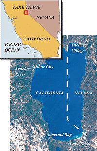
The major objective of this survey was to map the bathymetry of Lake Tahoe, California-Nevada to fulfill a commitment made during the Lake Tahoe Presidential Forum in 1997. The only existing bathymetry of Lake Tahoe, collected in 1923, was recently compiled by Rowe and Stone (1997), but the data density is inadequate for the level of scientific studies ongoing and anticipated in the near future for Lake Tahoe. Recent advances in marine multibeam-sonar capabilities now permit a cost-effective way, to precisely map the bathymetry of large areas of the ocean floor with 100% coverage. This survey applied this state-of-the-art ocean technology to Lake Tahoe. The newest of these high-resolution multibeam mapping systems also simultaneously collects backscatter (similar to sidescan sonar) imagery that results in a complimentary and co-registered data set that is related to the distribution of lake-floor materials and textures. The two types of maps that resulted from this cruise provide the multidisciplinary Lake Tahoe research community an unprecedented set of base maps upon which to build their studies.
In July 2000, the shallow regions of the lake not mapped by the multibeam sonar system were mapped by the US Army Corps of Engineers' SHOALS airborne lidar system. The two datasets have been merged together to show the complete bathymetry of Lake Tahoe, shoreline to the deepest depths.
For more information about Lake Tahoe, please visit The Lake Tahoe Data Clearinghouse.
PDF Format: James V. Gardner, Larry A. Mayer, and John E. Hughes Clarke. May 2000. Morphology and Processes in Lake Tahoe (California-Nevada). Geological Society of America Bulletin, v. 112; no. 5; p. 736-746. (390kb).
PDF Format: Cruise Report RV Inland Surveyer Cruise IS-98, The bathymetry of Lake Tahoe, California-Nevada, US Geological Survey Open-File Rept. 98-509, 28p. (2.0mb) Metadata
