Home - Images - Products - Data - Publications - Contact
Back to Maui Perspective Views
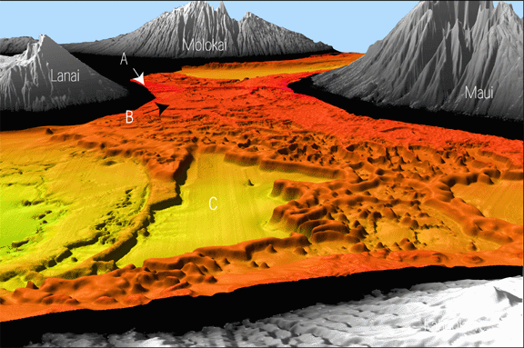
Oblique overview of the seafloor between Kahoolawe (foreground), Molokai (background), Lanai (left side), and Maui (right side). Distance between Lanai and Maui about 20 km. The sparse red regions between Lanai and Maui (A) are the present living reefs in water depths of less than 40 m, dark orange areas (B) are drown reef platforms and pinnacles in water depths between 50 and 85 m. Large basin in middle of view (C) is shown in more detail in Figs. 2 and 3. Maui is known to be subsiding about 2 mm/y under the load of the volcano, a rate that must have slowed with time. In addition, long-term sea level rises and falls at about 2 mm/y. The area between Lanai and Maui has filled with lava flows as the islands subsided and vertical growth of coral reefs kept pace with sea level fluctuations and island subsidence. Coral growth in the area between Lanai, Kahoolawe, and Maui has not kept pace with fluctuations in sea level, island subsidence, and lava-flow buildup, and is now drowned. The scale across the bottom of the image is10 km. The vertical exaggeration is 5x.
