USGS - science for a changing world

USGS Coastal and Marine Geology Program

Field Activity Details for field activity F486BS

View new CMGDS report form

AKA: none

Other ID: F-4-86-BS

Status: Completed

Organization(s): USGS, Pacific Coastal and Marine Science Center

Funding Program(s): Geological Long-Range Inclined Asdic (GLORIA) (MU116)

Principal Investigator(s): Alan Cooper, Andy Stevenson

Affiliate Investigator(s):

Information Specialist(s):

Data Type(s): Electro-Magnetic: Gravity, Electro-Magnetic: Magnetics, Environmental Data: Conductivity, Environmental Data: Temperature, Location-Elevation: Navigation, Seismics: Air Gun / Water Gun, Seismics: Multichannel, Seismics: Sub Bottom Profiler, Sonar: Sidescan, Sonar: Single Beam

Scientific Purpose/Goals:

Vehicle(s):

Start Port/Location:

End Port/Location: CRUISE and CRUISE

Start Date: 1986-09-03

End Date: 1986-09-30

Equipment Used: 3.5khz, 2channelairgun, Gloriasidescan, gravity, gradiometer, expendablebatthermograph, integratednavigation, 10khz, airgun

Information to be Derived:

Summary of Activity and Data Gathered:

Staff: Guy Cochrane

Affiliate Staff:

Notes: Geological LOng-Range Inclined Asdic (GLORIA) Umnak Plateau area Associated cruises in Alaska F-1-87-BS F-2-86-BS F-3-86-BS F-4-86-BS

Staff information imported from InfoBank
Alan Cooper (USGS Western Region) - Chief Scientist
Andy Stevenson (USGS Western Region) - Chief Scientist

Location:

Alaska

Boundaries
North: 55.98151441 South: 51.8436 West: -176.1365 East: -165.71449

Platform(s):

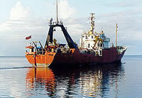
photo of Farnella
Farnella

Publications

Carlson, P.R., Karl, H.A., Edwards, B.D., Gardner, J.V., and Hall, R., 1993, Mass movement related to large submarine canyons along the Beringian margin, Alaska, in Schwab, W.C., Lee, H.J., Twichell, D.C., eds., Submarine landslides; selected studies in the U.S. Exclusive Economic Zone: U. S. Geological Survey Bulletin 2002, pp. 104–116.

Carlson, P.R., Cooper, A.K., Gardner, J.V., Hunter, R.E., Karl, H.A., Marlow, M.S., Stevenson, A.J., Huggett, Q., Kenyon, N.H., Parson, L.M., Bohannon, R.G., Edwards, B.D., Vallier, T.L., Dobson, M.F., and Masson, D.G., 1988, GLORIA sonographic mosaics of the Bering Sea and the western Aleutian Arc and adjacent North Pacific, in Carter, Lorna M., ed., USGS research on energy resources, 1988; program and abstracts: U. S. Geological Survey Circular 1025, pp. 14–15, https://pubs.er.usgs.gov/publication/cir1025.

Carlson, P.R., Cooper, A.K., Gardner, J.V., Karl, H.A., Marlow, M.S., Stevenson, A.J., Huggett, Q., Kenyon, N.H., and Parson, L., 1987, GLORIA side-scan imagery of Aleutian Basin, Bering Sea slope and abyssal plain: American Association of Petroleum Geologists Bulletin, v. 71 no. 5, pp. 536–536.

Carlson, P.R., Cooper, A.K., Gardner, J.V., Karl, H.A., Marlow, M.S., Stevenson, A.J., Huggett, Q., Kenyon, N.H., and Parson, L.M., 1987, Long-range side scan sonar and geophysical survey of the Aleutian Basin: American Geophysical Union Eos, Transactions, v. 68 no. 9, pp. 122–123.

Carlson, P.R., Marlow, M.S., Cooper, A.K., Stevenson, A.J., and Parson, L.M., 1986, First GLORIA images of giant Bering canyons: , Society For Sedimentary Geology Midyear Meeting Abstracts. , pp. 18–18.

Carlson, P.R., Karl, Herman A., and Edwards, Brian D., 1991, Mass sediment failure and transport features revealed by acoustic techniques, Beringian margin, Bering Sea, Alaska: Marine Geotechnology, v. 10 no. 1-2, pp. 33–51.

Carlson, P.R., Karl, Herman A., Edwards, Brian D., Gardner, James V., and Hall, Robert K., 1990, Submarine slumps, slides, and flows dominate sculpting of Beringian margin, Alaska: American Association of Petroleum Geologists Bulletin, v. 74 no. 6, pp. 963–963.

Cooper, A.K., Stevenson, A.J., Kenyon, N.H., and Bishop, D., 1986, GLORIA study of the Exclusive Economic Zone off Alaska, southern Bering Sea; initial report for cruise F4-86-BS, 3 September to 30 September 1986: U.S. Geological Survey Open-File Report 86-0596, 19 p., https://pubs.er.usgs.gov/publication/ofr86596.

Hall, R.K., Karl, H.A., Carlson, P.R., Cooper, A.K., Gardner, J.V., Hunter, R.E., Marlow, M.S., and Stevenson, A.J., 1988, Bathymetric map of the Bowers Basin and Aleutian Basin east of the U.S.-U.S.S.R. 1867 Convention Line, Bering Sea: U.S. Geological Survey Open-File Report 89-0548, 8 p., https://pubs.er.usgs.gov/publication/ofr89548.

Marlow, M.S., Cooper, A.K., Dadisman, S.V., Geist, E.L., and Carlson, P.R., 1990, Bowers swell â Evidence for a zone of compressive deformation concentric with Bowers Ridge, Bering Sea: Marine and Petroleum Geology, v. 7 no. 4, pp. 398–409.

Paskevich, V.F., Wong, F.L., O'Malley, J.J., Stevenson, A.J., and Gutmacher, C.E., 2011, GLORIA sidescan-sonar imagery for parts of the U.S. Exclusive Economic Zone and adjacent areas: U.S. Geological Survey Open-File Report 2010-1332, http://pubs.usgs.gov/of/2010/1332/.

Stevenson, A.J., Karl, H.A., Gardner, J.V., Cooper, A.K., Carlson, P.R., and Edwards, B.D., 1988, Slope failure and sediment mass movement on the margins of the Aleutian Basin, styles and causes: , Geological Society of America Abstracts with Programs. , pp. 129–129.

Portals/Viewers

FAN F486BS has data viewable in the GeoMappApp/Virtual Ocean applications. To view this data in these applications go to http://www.geomapapp.org/ and http://www.virtualocean.org/. See the instructions for locating USGS data in these applications. You can also view the imagery created from the SEGY data at https://cmgds.marine.usgs.gov/images.php?cruise=F486BS.

Data Acquired

Survey EquipmentSurvey InfoData Type(s)Data Collected
3.5khz --- Sub Bottom Profiler
Survey information
2channelairgun --- Multichannel
156764 260 13 52 LINE 143 - 261 07 05 LINE 144
156763 255 04 01 LINE 128 - 255 22 14 LINE 130
156764 246 21 36 LINE TR - 247 22 15 LINE 110
156763 259 15 28 LINE 140 - 260 15 28 LINE 142
156763 261 21 40 LINE 148 - 262 14 42 LINE 150
156763 261 07 06 LINE 145 - 261 21 38 LINE 147
156763 263 00 10 LINE 154 - 263 11 35 LINE 156
156763 266 13 03 LINE 162 - 267 06 03 LINE 163
156763 265 18 42 LINE 161 - 266 13 02 LINE 161
156763 271 05 39 LINE 176 - 271 15 28 LINE 177
156763 269 21 30 LINE 172 - 270 17 45 LINE 173
156764 246 23 50 LINE TR - 247 22 15 LINE 110
156764 250 04 20 LINE 115 - 251 13 44 LINE 116
156764 250 04 17 LINE 115 - 252 00 00 LINE 117
156764 254 07 25 LINE 126 - 255 04 00 LINE 127
156764 253 12 24 LINE 124 - 254 07 24 LINE 125
156764 258 06 00 LINE 136 - 258 22 54 LINE 137
156764 262 14 44 LINE 151 - 263 00 40 LINE 153
156764 261 21 45 LINE 148 - 262 14 42 LINE 150
156764 267 06 06 LINE 164 - 268 00 11 LINE 165
156764 266 13 04 LINE 162 - 267 06 03 LINE 163
156764 268 15 48 LINE 168 - 269 08 20 LINE 169
156764 271 05 33 LINE 176 - 271 15 28 LINE 177
156764 247 22 15 LINE 111 - 248 16 10 LINE 112 PART 2
Survey information
156763 270 17 46 LINR 174 - 271 05 30 LINE 175
seismic (data on FAD)
156764 248 16 10 LINE 113 - 250 04 10 LINE 114
156764 252 03 39 LINE 118 - 252 16 46 LINE 121
156764 252 16 51 LINE 122 - 252 04 40 LINE 123
156764 253 04 50 LINE 123 - 253 12 17 LINE 123
156764 253 12 21 LINE 124 - 254 07 24 LINE 125
156764 255 22 16 LINE 130 - 256 17 54 LINE 131
Multichannel data (srt data) (Download SEG-Y files from National Archive of Marine Seismic Surveys (NAMSS))
156764 256 17 56 LINE 132 - 256 20 13 LINE 132
156763 256 18 45 LINE 132 - 256 20 13 LINE 133
156763 256 20 15 LINE 133 - 257 14 15 LINE 135
156763 263 11 41 LINE 157 - 264 14 30 LINE 158
156763 271 15 29 LINE 178 - 271 21 15 LINE 179
156764 264 14 32 LINE 159 - 265 18 29 LINE 160
156764 269 08 22 LINE 170 - 269 21 27 LINE 171
Edited seismic shot point data f-4-86-bs.422_070 (Provisional best file)
156764 257 14 21 LINE 135 - 258 05 58 LINE 135
156763 258 06 32 LINE 136 - 258 22 54 LINE 137
156763 258 22 55 LINE 138 - 259 15 27 LINE 139
156763 260 13 51 LINE 143 - 261 07 05 LINE 144
156764 263 11 38 LINE 157 - 264 14 30 LINE 158
156763 268 00 12 LINE 166 - 268 15 42 LINE 167
156764 270 17 52 LINE 174 - 271 05 30 LINE 175
156763 268 15 48 LINE 168 - 269 08 20 LINE 169
156763 246 22 27 LINE 110 - 271 21 15 LINE 179
156764 251 14 39 LINE 117 - 252 16 46 LINE 121
156764 254 07 30 LINE 126 - 255 04 00 LINE 127
156764 256 20 28 LINE 133 - 257 14 18 LINE 134
156764 258 23 02 LINE 138 - 259 15 27 LINE 139
156764 261 07 13 LINE 145 - 261 21 38 LINE 147
156763 264 14 31 LINE 159 - 265 18 28 LINE 160
156764 268 00 13 LINE 166 - 268 15 47 LINE 167
156764 269 21 27 LINE 172 - 270 17 45 LINE 173
Edited seismic shot point data f-4-86-bs.422
156764 247 22 15 LINE 111 - 248 16 10 LINE 112 PART 1
156764 252 00 12 LINE 117 - 252 03 24 LINE 117
156764 252 16 50 LINE 122 - 253 12 17 LINE 123
156764 255 04 05 LINE 128 - 255 24 14 LINE 130
156763 255 12 15 LINE 130 - 256 17 54 LINE 131
156763 257 14 22 LINE 135 - 258 05 58 LINE 135
156764 259 15 31 LINE 140 - 259 13 50 LINE 142
156763 262 14 43 LINE 151 - 262 23 21 LINE 153
NAMSS Air gun data
156764 248 16 19 LINE 113 - 250 04 10 LINE 114
156764 263 00 43 LINE 154 - 263 11 37 LINE 156
156764 265 18 38 LINE 161 - 266 13 02 LINE 161
156763 267 06 07 LINE 164 - 268 00 11 LINE 165
156763 269 08 57 LINE 170 - 269 21 30 LINE 171
156764 271 15 29 LINE 178 - 271 21 15 LINE 179
Seismic FFID/Shot/CDP data f-4-86-bs.410_070
Edited seismic shot point data f-4-86-bs.420
Gloriasidescan --- Sidescan
Survey information
Gloria (data on FAD)
File list
Sidescan mosaic
gravity --- Gravity
Raw gravity data from digital meter f-4-86-bs.101
Gravity land tie data f-4-86-bs.140
Free Air Anomaly data f-4-86-bs.162
Survey information
NGDC MGD77 data - gravity
Raw gravity data from digital meter f-4-86-bs.102
Gravity lines start/end control data f-4-86-bs.131
Free Air Anomaly data f-4-86-bs.160
SKIPNSAVED Free Air Anomaly data f-4-86-bs.150
Free Air Anomaly data f-4-86-bs.161
SKIPNSAVED Free Air Anomaly data f-4-86-bs.151
SKIPNSAVED Free Air Anomaly data f-4-86-bs.151_070 (Provisional best file)
Gravity lines start/end control data f-4-86-bs.130
gradiometer --- Magnetics
Raw gradiometer data f-4-86-bs.242_070
Cooper-format gradiometer data f-4-86-bs.270
Raw gradiometer data f-4-86-bs.242
Edited gradiometer data f-4-86-bs.261_070 (Provisional best file)
NGDC MGD77 data - Magnetics
Survey information
Raw gradiometer data f-4-86-bs.240
Raw gradiometer data f-4-86-bs.241
expendablebatthermograph --- Temperature
Station Information
integratednavigation --- Navigation
Eotvos/course/speed/distance data f-4-86-bs.072
Eotvos/course/speed/distance data f-4-86-bs.070_degree
Integrated navigation (SINS) data f-4-86-bs.050
Lines
Best file with nav in ArcInfo E00 format
Tape list
Eotvos/course/speed/distance data f-4-86-bs.070 (Provisional best file)
10khz --- Single Beam
NGDC MGD77 data - bathy
Edited bathymetry data f-4-86-bs.332
Survey information
Raw depth (bathymetry) data f-4-86-bs.300
Edited bathymetry data f-4-86-bs.332_070 (Provisional best file)
airgun --- Air Gun / Water Gun
Survey information

Accessibility FOIA Privacy Policies and Notices

U.S. Department of the Interior | U.S. Geological Survey
Questions or Comments? Contact CMGDS Team
https://cmgds.marine.usgs.gov