AKA: none
Other ID: S-1-97-SC
Status: Completed
Organization(s):
Funding Program(s):
Principal Investigator(s): Kim Klitgord
Affiliate Investigator(s):
Information Specialist(s): Kaye Kinoshita
Data Type(s): Location-Elevation: Navigation, Sampling: Geology, Seismics: Air Gun / Water Gun, Seismics: Multichannel, Seismics: Sub Bottom Profiler
Scientific Purpose/Goals:
Vehicle(s):
Start Port/Location:
End Port/Location:
Start Date: 1997-05-26
End Date: 1997-06-01
Equipment Used: 3.5khz, gravitycore, pipedredge, 24channel, navigation, airgun
Information to be Derived:
Summary of Activity and Data Gathered:
Staff: Brian Edwards, Patrick Hart, Homa Lee, Walt Olson, Fred Payne, Jane Reid, Bill Robinson, Ray Sliter, Hal Williams
Affiliate Staff:
Notes:
Staff information imported from InfoBank
Kim Klitgord (USGS Western Region) - Chief Scientist
Kaye Kinoshita (USGS Western Region) - Information Specialist
Pat Hart (USGS Western Region) - Geophysicist
Ray Sliter (USGS Western Region) - Geophysicist
Walter Barnhardt (USGS Western Region) - Geophysicist
Brian Edwards (USGS Western Region) - Geologist
Homa Lee (USGS Western Region) - Geologist
Jane Reid (USGS Western Region) - Watchstander
Bill Robinson (USGS Western Region) - Electronics Technician
Walt Olson (USGS Western Region) - Mechanical Technician
Hal Williams (USGS Western Region) - Mechanical Technician
Fred Payne (USGS Western Region) - Electronics Technician
Location:
California
| Boundaries | |||
|---|---|---|---|
| North: 34.02234 | South: 32.63382 | West: -118.887 | East: -117.23621 |
Platform(s):
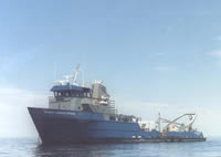
 Robert Gordon Sproul |
Ryan, H.F., Conrad, J.E., Paull, C.K., McGann, M., 2012, Slip Rate on the San Diego Trough Fault Zone, Inner California Borderland, and the 1986 Oceanside Earthquake Swarm Revisited: Bulletin of the Seismological Society of America, v. 102 no. 6, pp. 2300–2312, doi: 10.1785/0120110317.
Sliter, R.W., Normark, William R., and Gutmacher, Christina E., 2005, Multichannel seismic-reflection data acquired off the coast of southern California-Part A 1997, 1998, 1999, and 2000: U.S. Geological Survey Open-File Report 2005-1084, http://pubs.usgs.gov/of/2005/1084/.
FAN S197SC has data viewable in the GeoMappApp/Virtual Ocean applications. To view this data in these applications go to http://www.geomapapp.org/ and http://www.virtualocean.org/. See the instructions for locating USGS data in these applications. You can also view the imagery created from the SEGY data at https://cmgds.marine.usgs.gov/images.php?cruise=S197SC.
| Survey Equipment | Survey Info | Data Type(s) | Data Collected |
|---|---|---|---|
| 3.5khz | --- | Sub Bottom Profiler | |
| gravitycore | --- | Geology | |
| pipedredge | --- | Geology | |
| 24channel | --- | Multichannel | mcs (data on FAD) migrated (data on FAD) Multichannel data (stack data) Seismic FFID/Shot/CDP data s-1-97-sc.410_mcs |
| navigation | --- | Navigation | Best file with nav in ArcInfo E00 format Global positioning system (GPS) data s-1-97-sc.062 (Provisional best file) |
| airgun | --- | Air Gun / Water Gun |