|
|
Instrument Deployments
During the USGS study, instrumented tripods were deployed and recovered at LT-A three times each year, typically in February, May or June, and September. This report presents photographs obtained during 18 deployments that took place during the period December 1989 to October 1996. The deployments are identified by a three-digit USGS mooring number that is assigned sequentially to all instrument deployments (table 2). Cameras on Tripod 396 (February to June 1992) and Tripod 465 (February to June 1996) failed to operate and left gaps in the time-series data. Each tripod was located near the USCG Boston Approach B Buoy (National Ocean Service, 1997) on the southern flank of a ridge in water about 32 m deep (fig. 7). This location was selected for long-term observations because the USCG buoy marked the site and provided some protection from other marine activities.
Table 2. USGS mooring number, date, location, and water depth of time-series photographs contained in this Data Series report.
Mooring
number |
Start/Stop date
|
Latitude (N) |
Longitude (W) |
Water depth
(m) |
| 338 |
December 5, 1989 to
March 28, 1990 |
42° 23.65' |
70° 47.27' |
29 |
| 347 |
July 10, 1990 to
October 23, 1990 |
42° 22.66' |
70° 46.97' |
34 |
| 358 |
October 24, 1990 to
February 12, 1991 |
42° 22.62' |
70° 47.10' |
30 |
| 374 |
February 12, 1991 to
June 11, 1991 |
42° 22.62' |
70° 47.12' |
30 |
| 383 |
June 11, 1991 to
October 15, 1991 |
42° 22.63' |
70° 47.07' |
30 |
| 389 |
October 16, 1991 to
October 30 1991 |
42° 22.63' |
70° 47.11' |
30 |
| 400 |
June 2, 1992 to
October 20, 1992 |
42° 22.63' |
70° 47.07' |
30 |
| 407 |
October 20, 1992 to
February 18, 1993 |
42° 22.62' |
70° 47.07' |
30 |
| 413 |
February 25, 1993 to
June 15, 1993 |
42° 22.47' |
70° 47.12' |
32 |
| 420 | June 15, 1993 to
October 6, 1993 | 42° 22.55' | 70° 47.23' | 32 |
| 428 | October 5, 1993 to
February 13, 1994 | 42° 22.53' | 70° 47.12' | 32
|
| 430 | February 15, 1994 to
June 6, 1995 | 42° 22.54' | 70° 47.22' | 31
|
| 440 | June 7, 1994 to
October 4, 1994 | 42° 22.44' | 70° 46.96' | 33
|
| 445 | October 4, 1994 to
February 11, 1995 | 42° 22.43' | 70° 46.98' | 33
|
| 450 | February 15, 1995 to
June 13, 1995 | 42° 22.47' | 70° 46.86' | 33
|
| 460 | June 13, 1995 to
September 26, 1995 | 42° 22.62' | 70° 47.07' | 31
|
| 462 | September 26, 1995 to
February 3, 1996 | 42° 22.62' | 70° 47.07' | 32
|
| 470 | June 11, 1996 to
October 1, 1996 | 42° 22.63' | 70° 47.07' | 31 |
|
Click on thumbnail below for figure in PDF format.
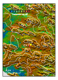 Figure 7.
Location of tripod moorings (over-lapping red triangles) at LT-A in western Massachusetts Bay deployed from 1989-2005.
|