|
U.S. Geological Survey Open-File Report 02-002
Geological Framework Data from Long Island Sound, 1981-1990:
A Digital Data Release
Navigation and Positions of the 1988 MMS Cores
|
|
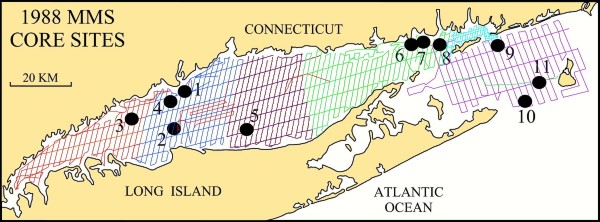
Navigation for 1988 MMS coresThe map below shows the locations of 11 vibracores collected in Long Island and Block Island Sounds during 1988 aboard the Atlantic Twin as part of a cooperative between the State of Connecticut, the Minerals Management Service, and the Association of American State Geologists. Navigation is provided for three other cores (not shown on the map) collected on this cruise in Rhode Island Sound. Locations of these 3 cores from Rhode Island Sound are shown in the summary report. Colored lines on map show locations of the tracklines along which the high-resolution seismic-reflection data provided on this DVD were collected. The cores were used to verify interpretations of these seismic data (Lewis and Stone, 1991; Lewis and DiGiacomo-Cohen, 2000).
Map illustration: Location of MMS 88 cores collected during the Atlantic Twin 88-1 (AT88-1) cruise. The navigation files, which are located in the data/cores/mms88 directory at the top level of this report, are provided in two formats and are listed below. Select the ArcView shapefile name to view the data layer's metadata.
These files are a compilation of the core-site locations and have the following data fields: cruise id, date, core number, and latitude and longitude in decimal degrees. To download the navigation data from the DVD the user has a couple of options. One option is available while viewing any of the data files through the links above. The user may select the Save As option from the pulldown menu from the File option located on the menu bar. When prompted, the user may then enter the directory and filename of where the data file will be stored on disk. A second option is to access the DVD outside of a WWW browser and copy the file from the data/cores directory on the DVD to a desired location. |

|