Woods Hole Science Center
|
|
Section 1 - Introduction
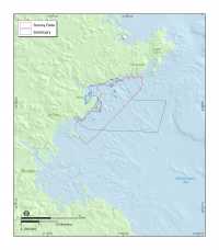
This report presents high-resolution maps of the seafloor offshore of Massachusetts, from Nahant to Gloucester. Approximately 134 km² of the inner shelf were mapped with a focus on the nearshore region in water depths less than 40 m (fig. 1.1). The maps were prepared as part of a cooperative mapping program between the U.S. Geological Survey (USGS) and the Massachusetts Office of Coastal Zone Management (CZM). They are based on marine geophysical data, sediment sampling, and bottom photography obtained on two research cruises carried out in 2003 and 2004. The primary objective of this program is to develop a suite of seafloor maps that provide geologic information for management of coastal and marine resources. Accurate maps of seafloor geology are important first steps toward protecting fish habitat, delineating marine reserves, and assessing environmental changes due to natural or human impacts. The maps also provide a geologic framework for scientific research, industry and the public. The organization of this report is outlined in the navigation bar along the left-hand margin of the page. This is section 1, the introduction. Section 2 briefly describes the mapping products contained in this report and has links to large-format map sheets, that can be viewed on line or downloaded. Section 3 is a description of the data collection, processing, and analysis procedures used to create the map products. Section 4 examines the geologic framework and late Quaternary evolution of the region, and presents two different strategies for mapping the complex seafloor. This report also contains four appendices that include GIS layers of all data collected in this study, and copies of the sample and photographic data used to validate the interpretations. |
 Back to List of Figures
 ![]() To Top of Page
To Top of Page  Forward to Next Section