
Woods Hole Science Center
Surficial Geology in Central Narragansett Bay, Rhode Island: Interpretations of Sidescan Sonar and Multibeam Bathymetry
![]() Title |
Introduction |
Geologic Setting |
Data Acquisition/Processing |
Multibeam Bathymetry |
Sidescan Sonar |
Sediment Distribution |
Environments |
Summary |
GIS Data Catalog |
Acknowledgments |
References |
Figures |
Contacts
Title |
Introduction |
Geologic Setting |
Data Acquisition/Processing |
Multibeam Bathymetry |
Sidescan Sonar |
Sediment Distribution |
Environments |
Summary |
GIS Data Catalog |
Acknowledgments |
References |
Figures |
Contacts
 |
||
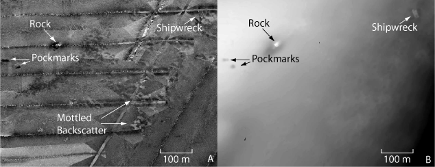
Figure 4. A. Sidescan sonar image of mottled backscatter, pockmarks, and a rock. B. Bathymetry image of the same area showing irregular bottom corresponding to mottled backscatter and scour to the southwest of the rock. Location of area shown in figure 1. | ||

