Woods Hole Science Center
Sidescan-Sonar Imagery, Multibeam Bathymetry, and Surficial Geologic Interpretations of the Sea Floor in Rhode Island Sound, off Sakonnet Point, Rhode Island
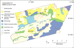
An analysis of sidescan-sonar data together with bathymetric and seismic-reflection data indicate six backscatter features in the study area including: rocky and bouldery areas, sand-wave fields, hummocky areas, tabular erosional outliers, small hills and scarps, and trawl marks. The bathymetry in the study area is composed of basins in the central and southwestern areas that have a relatively smooth sea floor aside from boulders, which are ubiquitous. Ridges around the basins are composed of glacial drift and have surfaces characterized by sand waves, a hummocky morphology, and erosional outliers (fig. 8). Sand wave fields are mostly located on the northern ridges and wave crests are roughly perpendicular to the slope. The moraine and areas of exposed till have a hummocky erosional surface. Tabular erosional outliers probably consist of cohesive glaciolacustrine sediment deposited in situ. Erosional scarps and small elongate hills, which parallel bathymetric contours and occur at depths similar to paleoshorelines in the region, were probably formed from outcropping strata that are resistant to erosion. Trawl marks are also evident. Sedimentary environments characterized by erosion or nondeposition are located on the moraine and the flanks of the ridges. Processes associated with coarse-grained bedload transport are prevalent along the northern regions; environments characterized by processes associated with sorting and reworking occur variously throughout the region where there are no sand waves or rocky areas. |