Woods Hole Science Center
Sidescan-Sonar Imagery, Multibeam Bathymetry, and Surficial Geologic Interpretations of the Sea Floor in Rhode Island Sound, off Sakonnet Point, Rhode Island
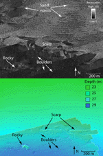
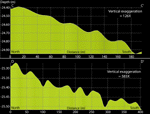
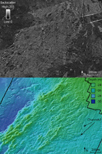
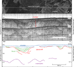
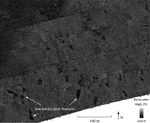
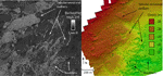
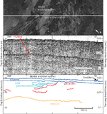
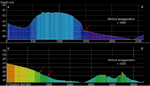
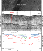
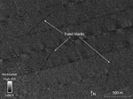
Bathymetric, seismic-reflection, and sediment data were used to help interpret the sidescan-sonar imagery (fig. 7). Six distinctive acoustic backscatter patterns are evident in the sidescan-sonar imagery (fig. 8). These patterns delineate rocky and bouldery areas, sand-wave fields, hummocky areas, tabular erosional outliers, small hills and scarps, and trawl marks. Rocky and Bouldery Areas Clustered, individual, high-backscatter targets with low-backscatter shadows are widespread throughout the region and are interpreted to be rocky and/or bouldery areas (fig. 9). Some boulders in the study area exceed 10 m in width. The largest areas of rocks and boulders are located in the southeastern, central, and northeastern parts of the study area, and are present both on ridges and in basins. Sand-wave Fields Areas of tiger-striped backscatter occur across much of the northern half of the study area and an area near the center of the survey. These areas tend to occur on bathymetric highs in areas of relatively high backscatter and are interpreted to be fields of sand waves (fig. 9). Most of the sand-wave fields are about 1-2 km² in area, though one field is over 6 km². A sand-wave field with straight to curved, north-south oriented crests is located in the northeastern corner of the survey. The wavelengths are 10-30 m and are nearly symmetrical. The sand waves in the north-central field have mostly curved and some straight crests that are east-west oriented and have wavelengths of 40 m to over 100 m. Between these two sand-wave fields are sand waves with curved, east-west oriented crests with wavelengths of about 50 m (fig. 9). The slip faces of these waves are oriented toward the north, suggesting a northward sediment transport direction (fig. 10). Another field of sand waves with curved, east-west oriented crests (though some are north-south oriented) is located in the northwest. The bathymetry shows the waves in the northwestern corner have slip faces oriented toward the north (fig. 10). In the north-central part of the study area there are two small sand-wave fields, each less than 0.1 km² in area, of sinuous crested waves oriented to the northeast with wavelengths of several meters. The sand waves in the center of the study area have curved crests oriented to the east-northeast. Hummocky Areas In the south, north-central, and northeastern corner of the study area, a mottled backscatter pattern appears in the sidescan-sonar imagery (fig. 11). The mottled areas in the south-central part of the study area appear in the bathymetry as mounds up to about 1 m in height and generally less than 100 m in width. The mottling covers areas as large as 7 km² and tends to coincide with exposures of a glacial moraine in the south and till deposits in the north (fig. 12). Mottled areas around the moraine in the southeast correspond to bathymetry that is cut by channels up to 1 m deep (fig. 11). The most prominent channels are oriented to the west, south, and south-southwest. The northeastern corner of the sidescan-sonar imagery shows mottled backscatter corresponding to variable bathymetry. The mottling is interpreted to indicate a hummocky, erosional surface. Within an area of mottled backscatter along the southern edge of the study area near the southwestern basin is an area with oblong to round, low-backscatter targets (fig. 13). The low-backscatter targets have sharp boundaries and look like acoustic shadows; however, there are no high-backscatter objects to create acoustic shadows. The low-backscatter targets are generally less than 10 m in width and around 10-40 m in length. If these features have relief, it is below the resolution of the multibeam bathymetry and the seismic-reflection data. Rocks and boulders are generally not located within the area of these features, but they exist to the north and east of the area. These features are seen to cross multiple tracking lines. They are inferred to be caused by patches of fine-grained sediment located within areas of coarser grained sediment. Tabular Erosional Outliers The sidescan-sonar imagery shows two areas, in the western and eastern parts of the study area, with varied high and low backscatter, while the corresponding bathymetry consists of small plateaus up to several hundred meters across and about 0.5 m high (fig. 14). The western area covers almost 4 km² and the eastern area covers about 0.5 km². The plateaus in the eastern part of the study area are eroded by a southerly oriented channel complex. sidescan-sonar data show that in the western area, the tops of the plateaus have lower backscatter and finer grained sediment, whereas the sea floor between the plateaus has higher backscatter and coarser grained, gravelly and bouldery sediment. Seismic data show horizontally stratified sediments that underlie the plateaus and areas to the northwest, which influence the bathymetry of the estuarine surface sediments (fig. 15). The plateaus differ from hummocky areas in that the individual plateaus are larger in area, they have flatter tops, a more drastic change in slope on their sides, and the plateaus are fine-grained with coarse-grained sediment between them. The plateaus are interpreted to be tabular erosional outliers composed of stratified glacial drift that is inferred to be cohesive glaciolacustrine sediment. The glaciolacustrine sediment onlaps till that is exposed to the southeast of the erosional outliers. Till, containing boulders up to 16 m in width, is also exposed between the erosional outliers where the thin lake sediments have been eroded away. Small Hills and Scarps Discontinuous, curvilinear features of high and low backscatter with sharp boundaries are evident in the sidescan-sonar imagery around the edges of the bathymetric lows (fig. 9). The patterns are oriented mostly east-west, perpendicular to the slope and askew to the ship track. Bathymetry in these areas show small hills, up to 0.5 m in height and, in the southwest, a change in slope from less than 0.5 degree to 3 degrees where the features are present (fig. 16). These features are up to 2.5 km long and occur in water depths of 24-27 m in the northeast and 30-35 m in the southwest. The low-backscatter curvilinear features appear to be produced by small, erosional scarps and small, elongate hills on the sloped sea floor. Scarps cause a sharp change in backscatter where the slope changes. The elongate hills run perpendicular to the general slope and create low-backscatter acoustic shadows where they are roughly parallel to the ship track, accounting for the sharp contrasts in backscatter. Because the hills and scarps in the sidescan-sonar imagery tend to coincide with fluvial deposits and drift deposits that have reflectors terminating near the surface (fig. 17) we infer that these paired features were formed by outcropping strata, which are more resistant to erosion than the surrounding sediments. Since these features tend to parallel the bathymetry and are located at depths similar to those of paleoshorelines described in nearby areas, they may mark paleoshorelines. Trawl Marks Anthropogenic features are also visible in the sidescan-sonar imagery. The central, northeastern, and southwestern areas of the study area contain several long, thin, straight lines of low backscatter, which are interpreted to be trawl marks from fishing boats (fig. 18). They range in length from about 100 m to 1 km. |