
Woods Hole Science Center
Sidescan-Sonar Imagery, Multibeam Bathymetry, and Surficial Geologic Interpretations of the Sea Floor in Rhode Island Sound, off Sakonnet Point, Rhode Island
![]() Title |
Introduction |
Geologic Setting |
Data Acquisition/Processing |
Bathymetry |
Sidescan-Sonar Imagery |
Environments |
Discussion |
Summary |
GIS Data Catalog |
Acknowledgments |
References |
Figures |
Contacts
Title |
Introduction |
Geologic Setting |
Data Acquisition/Processing |
Bathymetry |
Sidescan-Sonar Imagery |
Environments |
Discussion |
Summary |
GIS Data Catalog |
Acknowledgments |
References |
Figures |
Contacts
 |
||
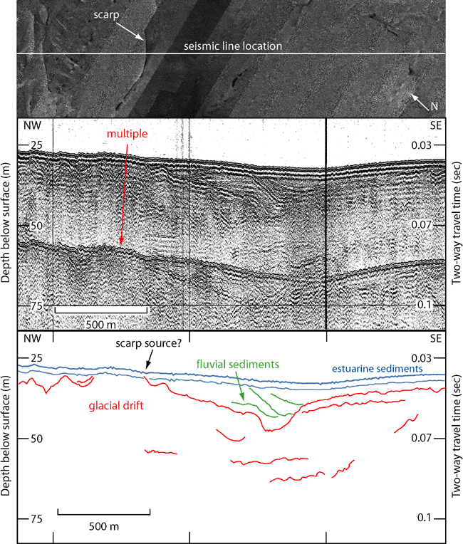
Figure 17. Sidescan-sonar imagery, Boomer seismic-reflection profile (O'Hara and Oldale, 1980), and interpretation of an area with small scarps of outcropping strata. Top image shows scarp and location of seismic line on sidescan-sonar mosaic. Bottom images of seismic line and interpretation show Pleistocene glacial drift overlain by Holocene fluvial and estuarine sediments. The small scarp displayed within the sidescan-sonar mosaic is presumed to correspond to the prominent reflector between the fluvial sediments and glacial drift as it nears the surface. Vertical exaggeration: 15X. Depths are based on the assumed compressional wave velocity of 1500 m/s. Location of seismic line shown in figure 2. | ||

