Woods Hole Science Center
Sidescan-Sonar Imagery, Multibeam Bathymetry, and Surficial Geologic Interpretations of the Sea Floor in Rhode Island Sound, off Sakonnet Point, Rhode Island
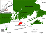
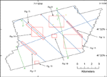
The U.S. Geological Survey (USGS) is working with the National Oceanic and Atmospheric Administration (NOAA) to interpret the surficial geology in estuaries and sounds along the northeastern coast of the United States. This report interprets the area covered by NOAA Survey H11320, about 72 km² of sea floor in eastern Rhode Island Sound (RIS), located about 8 km south of Sakonnet Point, Rhode Island (fig. 1). Previous work in RIS includes studies of both sea-floor processes and subsurface geologic framework. McMaster (1960) mapped surficial sediment samples in Narragansett Bay and RIS and McMaster and others (1968) conducted a seismic-reflection survey in Block Island Sound and RIS. O'Hara and Oldale (1980) collected seismic-reflection profiles, sidescan-sonar data, and vibracores in eastern RIS (fig. 2). They interpreted the geologic history, assessed sand and gravel resources, and evaluated the mining impact of these resources. McMaster's (1960) interpretation of the surficial sediment within this study area consisted of sand with several isolated areas of gravel. Several other sediment samples were previously obtained within the study area: three National Oceanographic Data Center (NODC) dredge samples from 1942 consisted of sand and one National Ocean Service (NOS) sample from 1939 was rocky (fig. 2; Poppe and others, 2003). The purpose of this report is to define the sea-floor morphology and sedimentary environments and interpret processes occurring on the sea floor using sidescan-sonar imagery, multibeam bathymetry, and historic seismic-reflection profiles. |