
Woods Hole Science Center
Sidescan-Sonar Imagery, Multibeam Bathymetry, and Surficial Geologic Interpretations of the Sea Floor in Rhode Island Sound, off Sakonnet Point, Rhode Island
![]() Title |
Introduction |
Geologic Setting |
Data Acquisition/Processing |
Bathymetry |
Sidescan-Sonar Imagery |
Environments |
Discussion |
Summary |
GIS Data Catalog |
Acknowledgments |
References |
Figures |
Contacts
Title |
Introduction |
Geologic Setting |
Data Acquisition/Processing |
Bathymetry |
Sidescan-Sonar Imagery |
Environments |
Discussion |
Summary |
GIS Data Catalog |
Acknowledgments |
References |
Figures |
Contacts
 |
||
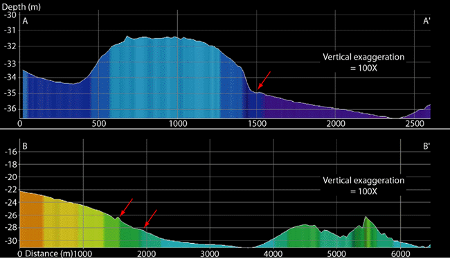
Figure 16. Bathymetric profiles across study area from north to south. Location of profiles shown in figure 2. Profile A-A', located in the southwestern part of the study area, crosses a bathymetric high with deeper basins to the north and south. Profile B-B', located in the eastern part of the study area, crosses a bathymetric high in the north, central basin, and moraine in the south. Arrows point to changes in slope interpreted to represent paleoshorelines. | ||

